
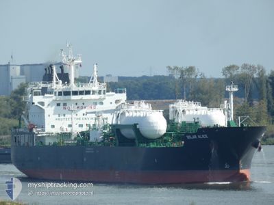
SOLAR ALICE
Tanker
Current Trip
| Time Travelled | 20 h, 8 mins |
|---|---|
| Remaining Time | 9 h, 54 mins |
| Distance Travelled | 263.70 nm |
| Remaining Distance | 138.70 nm |
| AVG Speed | 13.3 Knots |
| MAX Speed | 14.2 Knots |
| AVG Wind | 15.7 knots |
| MAX Wind | 24 knots |
| MIN Temp | 13.3°C / 55.94°F |
| MAX Temp | 16°C / 60.8°F |
| Draught | 7 m |
| Position Received | 1 m ago |
Current Position
| Longitude | 6.20380° |
|---|---|
| Latitude | 55.36324° |
| Status | Under way using engine |
| Speed | 13.5 Knots |
| Course | 179.7° |
| Area | North Sea |
| Station | T-AIS |
| Position Received | 1 m ago |
Info
Information
The current position of SOLAR ALICE is in North Sea with coordinates 55.36324° / 6.20380° as reported on 2024-06-01 19:41 by AIS to our vessel tracker app. The vessel's current speed is 13.5 Knots and is heading at the port of WILHELMSHAVEN. The estimated time of arrival as calculated by vessel tracking app is 2024-06-02 05:36 LT
The vessel SOLAR ALICE (IMO: 9887384, MMSI: 636020365) is a Tanker It's sailing under the flag of [LR] Liberia.
In this page you can find informations about the vessels current position, last detected port calls, and current voyage information. If the vessels is not in coverage by AIS you will find the latest position.
The current position of SOLAR ALICE is detected by our AIS receivers and we are not responsible for the reliability of the data. The last position was recorded while the vessel was in Coverage by the Ais receivers of our vessel tracking app.
The current draught of SOLAR ALICE as reported by AIS is 7 meters
Weather
| Temperature | 13.3°C / 55.94°F |
|---|---|
| Wind Speed | 23 knots |
| Direction | 344° NNW |
| Pressure | 1019.9 hPa |
| Humidity | 85.7 % |
| Cloud Coverage | 11 % |
Featured Company
Last Port Calls
| Port | Arrival | Departure | Time In Port |
|---|---|---|---|
| 2024-05-30 09:51 | 2024-05-31 23:34 | 1 d | |
| 2024-05-26 23:13 | 2024-05-28 14:50 | 1 d | |
| 2024-05-25 04:17 | 2024-05-26 09:22 | 1 d | |
| 2024-05-21 14:52 | 2024-05-22 17:13 | 1 d | |
| 2024-05-20 05:20 | 2024-05-21 12:35 | 1 d | |
| 2024-05-16 17:11 | 2024-05-18 01:42 | 1 d | |
| 2024-05-13 13:13 | 2024-05-14 03:39 | 14 h | |
| 2024-05-05 20:29 | 2024-05-11 03:39 | 5 d | |
| 2024-04-28 19:54 | 2024-05-01 14:51 | 2 d | |
| 2024-04-25 11:09 | 2024-04-25 23:18 | 12 h |
Last Trips
| Origin | Departure | Destination | Arrival | Distance | |
|---|---|---|---|---|---|
| 2024-05-28 16:50 | 2024-05-30 11:51 | 522.39 nm | |||
| 2024-05-26 10:22 | 2024-05-27 01:13 | 162.11 nm | |||
| 2024-05-22 19:13 | 2024-05-25 05:17 | 163.94 nm | |||
| 2024-05-21 14:35 | 2024-05-21 16:52 | 18.97 nm | |||
| 2024-05-18 02:42 | 2024-05-20 07:20 | 673.61 nm | |||
| 2024-05-14 04:39 | 2024-05-16 18:11 | 11.43 nm | |||
| 2024-05-11 05:39 | 2024-05-13 14:13 | 690.06 nm | |||
| 2024-05-01 15:51 | 2024-05-05 22:29 | 1206.15 nm | |||
| 2024-04-26 00:18 | 2024-04-28 20:54 | 24.41 nm | |||
| 2024-04-19 02:28 | 2024-04-25 12:09 | 1243.10 nm |
Events
| Time | Event | Details | Position / Dest | Info |
|---|---|---|---|---|
| 2024-06-01 19:32 | Change Sea Area | German part of the North Sea Danish part of the North Sea |
55.39778 / 6.20391
North Sea
WILHELMSHAVEN
|
Speed: 13.6 kn Course: 179.8° |
| 2024-06-01 19:30 | Status Changed | Under way using engine Default |
55.40284 / 6.20395
WILHELMSHAVEN
|
Speed: 13.5 kn Course: 179° |
| 2024-06-01 19:21 | Status Changed | Default Under way using engine |
55.43816 / 6.20384
WILHELMSHAVEN
|
Speed: 13.5 kn Course: 179.2° |
| 2024-06-01 09:11 | Change Sea Area | Danish part of the North Sea Danish part of the Skaggerak |
57.32890 / 8.22189
North Sea
WILHELMSHAVEN
|
Speed: 13.6 kn Course: 229.3° |
| 2024-06-01 02:17 | Change Sea Area | Danish part of the Skaggerak Swedish part of the Skaggerak |
58.08215 / 10.60584
Skaggerak
WILHELMSHAVEN
|
Speed: 12.6 kn Course: 255.7° |
| 2024-06-01 00:17 | ETA Changed | 2024/06/02 03:30 2024/06/02 08:00 |
58.28571 / 11.29107
WILHELMSHAVEN
|
Speed: 10.9 kn Course: 229.9° |
| 2024-05-31 23:34 | PORT DEPARTURE |
|
58.35774 / 11.43372
WILHELMSHAVEN
|
Speed: 3.7 kn Course: 297° |
| 2024-05-31 23:33 | START Moving |
58.35661 / 11.43611
[SE] BROFJORDEN
|
Speed: 3.4 kn Course: 318° |
|
| 2024-05-31 23:26 | Draught Changed | 7 9.4 |
58.35437 / 11.43615
[SE] BROFJORDEN
|
Speed: Course: 30° |
| 2024-05-31 23:26 | Destination Changed | WILHELMSHAVEN BROFJORDEN |
58.35437 / 11.43615
[SE] BROFJORDEN
|
Speed: Course: 30° |