
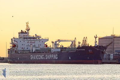
SOLAR SUSIE
Tanker B
Current Trip
| Time Travelled | 8 days |
|---|---|
| Remaining Time | 5 days |
| Distance Travelled | 1168.12 nm |
| Remaining Distance | 1682.90 nm |
| AVG Speed | 9 Knots |
| MAX Speed | 13.9 Knots |
| AVG Wind | 20.1 knots |
| MAX Wind | 30.9 knots |
| MIN Temp | 12.9°C / 55.22°F |
| MAX Temp | 25.1°C / 77.18°F |
| Draught | 12 m |
| Position Received | 10 h, 0 m ago |
Current Position
| Longitude | 117.64481° |
|---|---|
| Latitude | 23.33336° |
| Status | Under way using engine |
| Speed | 13.1 Knots |
| Course | 226.9° |
| Area | South China Sea |
| Station | T-AIS |
| Position Received | 10 h, 0 m ago |
Info
Information
The current position of SOLAR SUSIE is in South China Sea with coordinates 23.33336° / 117.64481° as reported on 2024-05-16 15:46 by AIS to our vessel tracker app. The vessel's current speed is 13.1 Knots and is heading at the port of PORT KLANG. The estimated time of arrival as calculated by vessel tracking app is 2024-05-22 14:09 LT
The vessel SOLAR SUSIE (IMO: 9898515, MMSI: 636019989) is a Tanker B It's sailing under the flag of [LR] Liberia.
In this page you can find informations about the vessels current position, last detected port calls, and current voyage information. If the vessels is not in coverage by AIS you will find the latest position.
The current position of SOLAR SUSIE is detected by our AIS receivers and we are not responsible for the reliability of the data. The last position was recorded while the vessel was in Coverage by the Ais receivers of our vessel tracking app.
The current draught of SOLAR SUSIE as reported by AIS is 12 meters
Weather
| Temperature | 24.3°C / 75.74°F |
|---|---|
| Wind Speed | 15 knots |
| Direction | 56° NE |
| Pressure | 1013.8 hPa |
| Humidity | 81.7 % |
| Cloud Coverage | 100 % |
Featured Company
Most Visited Ports (Last year)
| Port | Arrivals | |
|---|---|---|
| 3 | ||
| 3 | ||
| 3 | ||
| 2 | ||
| 2 | ||
| 2 |
Events
| Time | Event | Details | Position / Dest | Info |
|---|---|---|---|---|
| 2024-05-16 15:53 | Status Changed | Default Under way using engine |
23.31615 / 117.62821
PORT KLANG
|
Speed: 13.1 kn Course: 226.9° |
| 2024-05-16 15:46 | OUT of Coverage |
23.33336 / 117.64481
South China Sea
PORT KLANG
|
Speed: 13.1 kn Course: 226.9° |
|
| 2024-05-16 12:25 | Status Changed | Under way using engine Default |
23.84299 / 118.25461
PORT KLANG
|
Speed: 13.6 kn Course: 228° |
| 2024-05-16 12:20 | Status Changed | Default Under way using engine |
23.85626 / 118.27029
PORT KLANG
|
Speed: 13.7 kn Course: 226.2° |
| 2024-05-16 11:51 | Status Changed | Under way using engine Default |
23.93199 / 118.35803
PORT KLANG
|
Speed: 13.8 kn Course: 226° |
| 2024-05-16 11:48 | Status Changed | Default Under way using engine |
23.93877 / 118.36609
PORT KLANG
|
Speed: 13.9 kn Course: 216.8° |
| 2024-05-16 11:40 | Status Changed | Under way using engine Default |
23.96215 / 118.39010
PORT KLANG
|
Speed: 13.7 kn Course: 211° |
| 2024-05-16 11:33 | Status Changed | Default Under way using engine |
23.98708 / 118.40534
PORT KLANG
|
Speed: 13.8 kn Course: 206° |
| 2024-05-16 09:44 | ETA Changed | 2024/05/22 12:00 2024/05/16 06:08 |
24.29372 / 118.21185
PORT KLANG
|
Speed: 11.9 kn Course: 137° |
| 2024-05-16 08:11 | START Moving | 4.15 nm, North West of ZHANGZHOU |
24.44857 / 117.98762
PORT KLANG
|
Speed: 3.1 kn Course: 130° |