
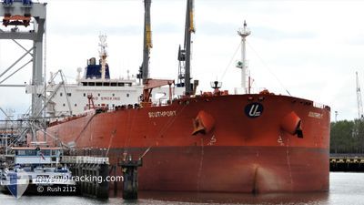
SOUTHPORT
Oil Products Tanker
Current Trip
MY MKZ
| Time Travelled | 1 day |
|---|---|
| Remaining Time | --- |
| Distance Travelled | 184.48 nm |
| Remaining Distance | --- |
| AVG Speed | 14.3 Knots |
| MAX Speed | 15.9 Knots |
| AVG Wind | 15 knots |
| MAX Wind | 21.8 knots |
| MIN Temp | 26.6°C / 79.88°F |
| MAX Temp | 29.7°C / 85.46°F |
| Draught | 11.3 m |
| Position Received | 4 d ago |
Current Position
| Longitude | 103.39828° |
|---|---|
| Latitude | 1.24000° |
| Status | Under way using engine |
| Speed | 9.7 Knots |
| Course | 296° |
| Area | Malacca Strait |
| Station | T-AIS |
| Position Received | 4 d ago |
Info
Information
The current position of SOUTHPORT is in Malacca Strait with coordinates 1.24000° / 103.39828° as reported on 2024-05-29 11:08 by AIS to our vessel tracker app. The vessel's current speed is 9.7 Knots
The vessel SOUTHPORT (IMO: 9408530, MMSI: 538003268) is a Oil Products Tanker that was built in 2008 ( 16 years old ). It's sailing under the flag of [MH] Marshall Is.
In this page you can find informations about the vessels current position, last detected port calls, and current voyage information. If the vessels is not in coverage by AIS you will find the latest position.
The current position of SOUTHPORT is detected by our AIS receivers and we are not responsible for the reliability of the data. The last position was recorded while the vessel was in Coverage by the Ais receivers of our vessel tracking app.
The current draught of SOUTHPORT as reported by AIS is 11.3 meters
Weather
| Temperature | 29.6°C / 85.28°F |
|---|---|
| Wind Speed | 9 knots |
| Direction | 238° WSW |
| Pressure | 1010.2 hPa |
| Humidity | 75.8 % |
| Cloud Coverage | 100 % |
Featured Company
Last Port Calls
| Port | Arrival | Departure | Time In Port |
|---|---|---|---|
| 2024-05-30 03:14 | 2024-06-01 07:02 | 2 d |
Most Visited Ports (Last year)
| Port | Arrivals | |
|---|---|---|
| 5 | ||
| 2 | ||
| 2 | ||
| 1 | ||
| 1 | ||
| 1 |
Last Trips
| Origin | Departure | Destination | Arrival | Distance |
|---|
Events
| Time | Event | Details | Position / Dest | Info |
|---|---|---|---|---|
| 2024-06-01 07:06 | START Moving | 1.43 nm, South West of SUNGAI UDANG |
2.23490 / 102.10712
MY MKZ
|
Speed: 4.7 kn Course: 187° |
| 2024-06-01 07:02 | PORT DEPARTURE |
|
2.23813 / 102.10962
MY MKZ
|
Speed: 2.9 kn Course: 261° |
| 2024-05-30 03:30 | STOP Moving |
2.24335 / 102.12130
[MY] SUNGAI UDANG
|
Speed: 0.3 kn Course: 333° |
|
| 2024-05-30 03:14 | PORT ARRIVAL |
|
2.23857 / 102.12350
[MY] SUNGAI UDANG
|
Speed: 5.5 kn Course: 46° |
| 2024-05-30 02:34 | START Moving | 3.24 nm, South West of SUNGAI UDANG |
2.20550 / 102.09185
MY MKZ
|
Speed: 3.6 kn Course: 100° |
| 2024-05-29 20:25 | STOP Moving | 3.28 nm, South West of SUNGAI UDANG |
2.20855 / 102.08797
MY MKZ
|
Speed: 0.2 kn Course: 141° |
| 2024-05-29 11:14 | Status Changed | Default Under way using engine |
1.24722 / 103.38496
MY MKZ
|
Speed: 9.7 kn Course: 296° |
| 2024-05-29 11:08 | Change Sea Area | Indonesian part of the Malacca Strait Malaysian part of the Malacca Strait |
1.24000 / 103.39828
Malacca Strait
MY MKZ
|
Speed: 9.7 kn Course: 296° |
| 2024-05-29 11:08 | Status Changed | Under way using engine Default |
1.24000 / 103.39828
MY MKZ
|
Speed: 9.8 kn Course: 295° |
| 2024-05-29 11:08 | OUT of Coverage |
1.24000 / 103.39828
Malacca Strait
MY MKZ
|
Speed: 9.7 kn Course: 296° |