
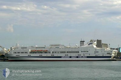
SPLENDID
Ro-Ro/Passenger Ship
Current Trip
| Time Travelled | 10 h, 24 mins |
|---|---|
| Remaining Time | 2 h, 58 mins |
| Distance Travelled | 166.41 nm |
| Remaining Distance | 48.28 nm |
| AVG Speed | 16.3 Knots |
| MAX Speed | 17.4 Knots |
| AVG Wind | 5.6 knots |
| MAX Wind | 10 knots |
| MIN Temp | 20.7°C / 69.26°F |
| MAX Temp | 22.2°C / 71.96°F |
| Draught | 6.5 m |
| Position Received | Now |
Current Position
| Longitude | 8.76926° |
|---|---|
| Latitude | 43.64359° |
| Status | Under way using engine |
| Speed | 15.6 Knots |
| Course | 13.2° |
| Area | Ligurian Sea |
| Station | T-AIS |
| Position Received | Now |
Info
Information
The current position of SPLENDID is in Ligurian Sea with coordinates 43.64359° / 8.76926° as reported on 2024-06-27 03:16 by AIS to our vessel tracker app. The vessel's current speed is 15.6 Knots and is heading at the port of GENOVA. The estimated time of arrival as calculated by vessel tracking app is 2024-06-27 06:15 LT
The vessel SPLENDID (IMO: 9015747, MMSI: 247136000) is a Ro-Ro/Passenger Ship that was built in 1994 ( 30 years old ). It's sailing under the flag of [IT] Italy.
In this page you can find informations about the vessels current position, last detected port calls, and current voyage information. If the vessels is not in coverage by AIS you will find the latest position.
The current position of SPLENDID is detected by our AIS receivers and we are not responsible for the reliability of the data. The last position was recorded while the vessel was in Coverage by the Ais receivers of our vessel tracking app.
The current draught of SPLENDID as reported by AIS is 6.5 meters
Weather
| Temperature | 20.6°C / 69.08°F |
|---|---|
| Wind Speed | 4 knots |
| Direction | 204° SSW |
| Pressure | 1011.6 hPa |
| Humidity | 85.2 % |
| Cloud Coverage | 8 % |
Featured Company
Last Port Calls
| Port | Arrival | Departure | Time In Port |
|---|---|---|---|
| 2024-06-26 06:16 | 2024-06-26 16:53 | 10 h | |
| 2024-06-25 09:48 | 2024-06-25 17:09 | 7 h | |
| 2024-06-24 15:24 | 2024-06-24 19:49 | 4 h | |
| 2024-06-23 23:10 | 2024-06-24 01:54 | 2 h | |
| 2024-06-22 04:12 | 2024-06-22 15:49 | 11 h | |
| 2024-06-19 17:33 | 2024-06-20 12:20 | 18 h | |
| 2024-04-14 07:15 | 2024-06-19 06:58 | ||
| 2024-04-06 05:47 | 2024-04-12 16:52 | 6 d | |
| 2024-04-05 00:31 | 2024-04-05 04:35 | 4 h | |
| 2024-04-03 07:47 | 2024-04-04 00:15 | 16 h |
Most Visited Ports (Last year)
| Port | Arrivals | |
|---|---|---|
| 62 | ||
| 54 | ||
| 51 | ||
| 42 | ||
| 28 | ||
| 25 |
Last Trips
| Origin | Departure | Destination | Arrival | Distance | |
|---|---|---|---|---|---|
| 2024-06-25 19:09 | 2024-06-26 08:16 | 214.56 nm | |||
| 2024-06-24 21:49 | 2024-06-25 11:48 | 218.06 nm | |||
| 2024-06-24 03:54 | 2024-06-24 17:24 | 217.44 nm | |||
| 2024-06-22 17:49 | 2024-06-24 01:10 | 362.49 nm | |||
| 2024-06-20 14:20 | 2024-06-22 06:12 | 593.87 nm | |||
| 2024-06-19 08:58 | 2024-06-19 19:33 | 105.31 nm | |||
| 2024-04-12 18:52 | 2024-04-14 09:15 | 594.76 nm | |||
| 2024-04-05 05:35 | 2024-04-06 07:47 | 467.40 nm | |||
| 2024-04-04 02:15 | 2024-04-05 01:31 | 466.31 nm | |||
| 2024-04-02 03:13 | 2024-04-03 09:47 | 447.96 nm |
Events
| Time | Event | Details | Position / Dest | Info |
|---|---|---|---|---|
| 2024-06-27 02:31 | Change Sea Area | Italian part of the Ligurian Sea French part of the Ligurian Sea |
43.45421 / 8.71769
Ligurian Sea
ITGOA
|
Speed: 15.1 kn Course: 10.1° |
| 2024-06-27 01:59 | Change Sea Area | French part of the Ligurian Sea French part of the Mediterranean Sea - Western Basin |
43.31691 / 8.68400
Ligurian Sea
ITGOA
|
Speed: 15.6 kn Course: 9.6° |
| 2024-06-26 18:53 | Change Sea Area | French part of the Mediterranean Sea - Western Basin Italian part of the Mediterranean Sea - Western Basin |
41.41646 / 8.41700
Mediterranean Sea - Western Basin
ITGOA
|
Speed: 17 kn Course: 358.7° |
| 2024-06-26 17:08 | Destination Changed | ITGOA ITPTO |
40.91474 / 8.41315
ITGOA
|
Speed: 17.3 kn Course: 4.9° |
| 2024-06-26 17:08 | ETA Changed | 2024/06/27 06:15 2024/06/26 06:15 |
40.91474 / 8.41315
ITGOA
|
Speed: 17.3 kn Course: 4.9° |
| 2024-06-26 17:03 | Status Changed | Under way using engine Moored |
40.89314 / 8.41042
ITPTO
|
Speed: 4.3 kn Course: 44° |
| 2024-06-26 16:53 | PORT DEPARTURE |
|
40.89314 / 8.41042
ITPTO
|
Speed: 4.3 kn Course: 44° |
| 2024-06-26 16:45 | Status Changed | Moored Default |
40.84425 / 8.39648
[IT] PORTO TORRES
|
Speed: Course: 11° |
| 2024-06-26 16:45 | START Moving |
40.84425 / 8.39648
[IT] PORTO TORRES
|
Speed: 4.3 kn Course: 44° |
|
| 2024-06-26 16:31 | Status Changed | Default Moored |
40.84296 / 8.39303
[IT] PORTO TORRES
|
Speed: Course: 11° |