
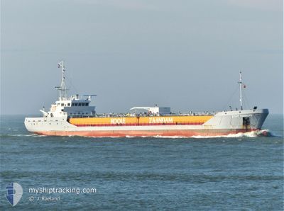
STAR BONAIRE
Edible Oil Tanker
Current Trip
| Time Travelled | 1 day |
|---|---|
| Remaining Time | --- |
| Distance Travelled | 223.19 nm |
| Remaining Distance | --- |
| AVG Speed | 8.8 Knots |
| MAX Speed | 11.7 Knots |
| AVG Wind | 18.1 knots |
| MAX Wind | 27.7 knots |
| MIN Temp | 8.9°C / 48.02°F |
| MAX Temp | 14.9°C / 58.82°F |
| Draught | 4.9 m |
| Position Received | 2 m ago |
Current Position
| Longitude | 0.09572° |
|---|---|
| Latitude | 53.54320° |
| Status | At anchor |
| Speed | 0.2 Knots |
| Course | 323° |
| Area | North Sea |
| Station | T-AIS |
| Position Received | 2 m ago |
Info
Information
The current position of STAR BONAIRE is in North Sea with coordinates 53.54320° / 0.09572° as reported on 2024-06-01 04:00 by AIS to our vessel tracker app. The vessel's current speed is 0.2 Knots
The vessel STAR BONAIRE (IMO: 9148453, MMSI: 246359000) is a Edible Oil Tanker that was built in 1997 ( 27 years old ). It's sailing under the flag of [NL] Netherlands.
In this page you can find informations about the vessels current position, last detected port calls, and current voyage information. If the vessels is not in coverage by AIS you will find the latest position.
The current position of STAR BONAIRE is detected by our AIS receivers and we are not responsible for the reliability of the data. The last position was recorded while the vessel was in Coverage by the Ais receivers of our vessel tracking app.
The current draught of STAR BONAIRE as reported by AIS is 4.9 meters
Weather
| Temperature | 9.5°C / 49.1°F |
|---|---|
| Wind Speed | 13 knots |
| Direction | 343° NNW |
| Pressure | 1023.8 hPa |
| Humidity | 95.8 % |
| Cloud Coverage | 21 % |
Featured Company
Last Port Calls
| Port | Arrival | Departure | Time In Port |
|---|---|---|---|
| 2024-05-29 21:22 | 2024-05-30 11:36 | 14 h | |
| 2024-05-27 11:13 | 2024-05-29 20:58 | 2 d | |
| 2024-05-26 10:15 | 2024-05-26 18:08 | 7 h | |
| 2024-05-25 14:56 | 2024-05-26 09:55 | 18 h | |
| 2024-05-25 03:04 | 2024-05-25 14:06 | 11 h | |
| 2024-05-23 07:48 | 2024-05-24 10:44 | 1 d | |
| 2024-05-21 22:36 | 2024-05-22 14:40 | 16 h | |
| 2024-05-20 11:46 | 2024-05-21 21:26 | 1 d | |
| 2024-05-16 21:54 | 2024-05-17 21:02 | 23 h | |
| 2024-05-13 17:38 | 2024-05-14 02:31 | 8 h |
Most Visited Ports (Last year)
| Port | Arrivals | |
|---|---|---|
| 24 | ||
| 22 | ||
| 20 | ||
| 19 | ||
| 18 | ||
| 11 |
Last Trips
| Origin | Departure | Destination | Arrival | Distance | |
|---|---|---|---|---|---|
| 2024-05-29 21:58 | 2024-05-29 22:22 | 2.19 nm | |||
| 2024-05-26 20:08 | 2024-05-27 12:13 | 169.92 nm | |||
| 2024-05-26 11:55 | 2024-05-26 12:15 | 0.49 nm | |||
| 2024-05-25 16:06 | 2024-05-25 16:56 | 10.10 nm | |||
| 2024-05-24 11:44 | 2024-05-25 05:04 | 158.79 nm | |||
| 2024-05-22 16:40 | 2024-05-23 08:48 | 171.20 nm | |||
| 2024-05-21 23:26 | 2024-05-22 00:36 | 9.89 nm | |||
| 2024-05-17 22:02 | 2024-05-20 13:46 | 756.35 nm | |||
| 2024-05-14 04:31 | 2024-05-16 22:54 | 745.11 nm | |||
| 2024-05-13 18:22 | 2024-05-13 19:38 | 10.24 nm |
Events
| Time | Event | Details | Position / Dest | Info |
|---|---|---|---|---|
| 2024-06-01 00:02 | ETA Changed | 2025/05/31 12:00 2024/05/31 12:00 |
53.54388 / .09213
GOOLE
|
Speed: 0.1 kn Course: 52° |
| 2024-05-31 13:45 | Status Changed | At anchor Under way using engine |
53.54255 / .09592
GOOLE
|
Speed: 0.4 kn Course: 316° |
| 2024-05-31 13:38 | STOP Moving | 6.24 nm, East of GRIMSBY |
53.54277 / .09530
GOOLE
|
Speed: 0.3 kn Course: 311° |
| 2024-05-31 13:12 | Status Changed | Under way using engine Default |
53.55290 / .16112
GOOLE
|
Speed: 8.6 kn Course: 282° |
| 2024-05-31 13:12 | IN Coverage |
53.55290 / .16112
North Sea
GOOLE
|
Speed: 8.6 kn Course: 310.5° |
|
| 2024-05-31 08:19 | Status Changed | Default Under way using engine |
53.13167 / .92833
GOOLE
|
Speed: 8.7 kn Course: 314.2° |
| 2024-05-31 08:10 | OUT of Coverage |
53.11725 / .95323
North Sea
GOOLE
|
Speed: 8.7 kn Course: 314.2° |
|
| 2024-05-31 04:08 | Status Changed | Under way using engine Default |
52.82068 / 1.73502
GOOLE
|
Speed: 6.4 kn Course: 301° |
| 2024-05-31 03:58 | IN Coverage |
52.82068 / 1.73502
North Sea
GOOLE
|
Speed: 6.6 kn Course: 305.3° |
|
| 2024-05-31 03:03 | OUT of Coverage |
52.75433 / 1.87195
North Sea
GOOLE
|
Speed: 5.3 kn Course: 307.9° |