
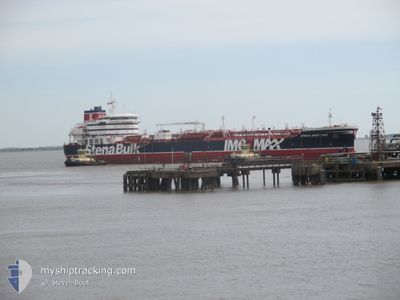
STENA IMPRIMIS
Tanker
Current Trip
WEST THURROCK JETTY1
| Time Travelled | 10 days |
|---|---|
| Remaining Time | --- |
| Distance Travelled | 2181.94 nm |
| Remaining Distance | --- |
| AVG Speed | 11 Knots |
| MAX Speed | 16.5 Knots |
| AVG Wind | 15.6 knots |
| MAX Wind | 27.8 knots |
| MIN Temp | 10.5°C / 50.9°F |
| MAX Temp | 21.6°C / 70.88°F |
| Draught | 11.2 m |
| Position Received | Now |
Current Position
| Longitude | 0.55104° |
|---|---|
| Latitude | 51.50334° |
| Status | Constrained by her draught |
| Speed | 12.7 Knots |
| Course | 273.3° |
| Area | North Sea |
| Station | T-AIS |
| Position Received | Now |
Info
Information
The current position of STENA IMPRIMIS is in North Sea with coordinates 51.50334° / 0.55104° as reported on 2024-06-01 19:06 by AIS to our vessel tracker app. The vessel's current speed is 12.7 Knots
The vessel STENA IMPRIMIS (IMO: 9797395, MMSI: 232010295) is a Tanker It's sailing under the flag of [GB] United Kingdom.
In this page you can find informations about the vessels current position, last detected port calls, and current voyage information. If the vessels is not in coverage by AIS you will find the latest position.
The current position of STENA IMPRIMIS is detected by our AIS receivers and we are not responsible for the reliability of the data. The last position was recorded while the vessel was in Coverage by the Ais receivers of our vessel tracking app.
The current draught of STENA IMPRIMIS as reported by AIS is 11.2 meters
Weather
| Temperature | 13.1°C / 55.58°F |
|---|---|
| Wind Speed | 12 knots |
| Direction | 357° N |
| Pressure | 1026.1 hPa |
| Humidity | 83.1 % |
| Cloud Coverage | 17 % |
Featured Company
Last Port Calls
| Port | Arrival | Departure | Time In Port |
|---|---|---|---|
| 2024-05-21 08:12 | 2024-05-22 16:45 | 1 d | |
| 2024-05-20 20:38 | 2024-05-21 07:19 | 10 h | |
| 2024-05-11 02:18 | 2024-05-11 18:26 | 16 h | |
| 2024-05-07 18:30 | 2024-05-08 23:08 | 1 d | |
| 2024-04-28 08:38 | 2024-04-29 09:05 | 1 d | |
| 2024-04-18 09:07 | 2024-04-19 09:07 | 1 d | |
| 2024-04-15 12:45 | 2024-04-18 06:38 | 2 d | |
| 2024-04-12 03:58 | 2024-04-14 02:34 | 1 d |
Most Visited Ports (Last year)
| Port | Arrivals | |
|---|---|---|
| 3 | ||
| 3 | ||
| 2 | ||
| 2 | ||
| 2 | ||
| 2 |
Last Trips
| Origin | Departure | Destination | Arrival | Distance | |
|---|---|---|---|---|---|
| 2024-05-21 09:19 | 2024-05-21 10:12 | 2.00 nm | |||
| 2024-05-11 20:26 | 2024-05-20 22:38 | 901.86 nm | |||
| 2024-05-09 01:08 | 2024-05-11 04:18 | 629.86 nm | |||
| 2024-04-29 11:05 | 2024-05-07 20:30 | 2005.81 nm | |||
| 2024-04-19 11:07 | 2024-04-28 10:38 | 122.35 nm | |||
| 2024-04-18 08:38 | 2024-04-18 11:07 | 19.47 nm | |||
| 2024-04-14 03:34 | 2024-04-15 14:45 | 174.48 nm | |||
| 2024-03-24 09:39 | 2024-04-12 04:58 | 5007.83 nm |
Events
| Time | Event | Details | Position / Dest | Info |
|---|---|---|---|---|
| 2024-06-01 18:05 | ETA Changed | 2024/06/01 21:30 2024/06/01 15:00 |
51.48626 / .90013
WEST THURROCK JETTY1
|
Speed: 12.9 kn Course: 288.3° |
| 2024-06-01 17:59 | Destination Changed | WEST THURROCK JETTY1 SUNK PILOT STATION |
51.48092 / .93589
WEST THURROCK JETTY1
|
Speed: 13.4 kn Course: 269.7° |
| 2024-06-01 17:35 | Status Changed | Constrained by her draught Under way using engine |
51.51605 / 1.06554
SUNK PILOT STATION
|
Speed: 13.7 kn Course: 240.6° |
| 2024-06-01 14:31 | START Moving | 15.94 nm, East of FELIXSTOWE |
51.89344 / 1.71551
SUNK PILOT STATION
|
Speed: 3.1 kn Course: 107° |
| 2024-06-01 14:04 | STOP Moving | 15.72 nm, East of FELIXSTOWE |
51.89122 / 1.70850
SUNK PILOT STATION
|
Speed: 0.3 kn Course: 20° |
| 2024-06-01 13:49 | ETA Changed | 2024/06/01 15:00 2024/06/01 14:30 |
51.89478 / 1.70957
SUNK PILOT STATION
|
Speed: 1.3 kn Course: 38° |
| 2024-06-01 13:31 | START Moving | 15.33 nm, East of FELIXSTOWE |
51.91031 / 1.70470
SUNK PILOT STATION
|
Speed: 3.1 kn Course: 130° |
| 2024-06-01 13:20 | Status Changed | Under way using engine At anchor |
51.91141 / 1.70251
SUNK PILOT STATION
|
Speed: 0.3 kn Course: 17° |
| 2024-06-01 12:57 | Destination Changed | SUNK PILOT STATION DW SUNK ANCHORAGE |
51.90978 / 1.70172
SUNK PILOT STATION
|
Speed: 0.1 kn Course: 18° |
| 2024-06-01 12:57 | ETA Changed | 2024/06/01 14:30 2025/05/31 23:30 |
51.90978 / 1.70172
SUNK PILOT STATION
|
Speed: 0.1 kn Course: 18° |