
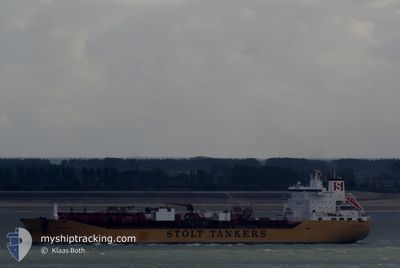
STOLT CAPABILITY
Oil/Chemical Tanker
Current Trip
| Time Travelled | 18 days |
|---|---|
| Remaining Time | --- |
| Distance Travelled | 5465.35 nm |
| Remaining Distance | --- |
| AVG Speed | 13.5 Knots |
| MAX Speed | 18 Knots |
| AVG Wind | 12.7 knots |
| MAX Wind | 28.4 knots |
| MIN Temp | 18.4°C / 65.12°F |
| MAX Temp | 31°C / 87.8°F |
| Draught | 11.3 m |
| Position Received | 5 d ago |
Current Position
| Longitude | 54.53927° |
|---|---|
| Latitude | -21.17154° |
| Status | Under way using engine |
| Speed | 14.2 Knots |
| Course | 236.4° |
| Area | Indian Ocean |
| Station | T-AIS |
| Position Received | 5 d ago |
Info
Information
The current position of STOLT CAPABILITY is in Indian Ocean with coordinates -21.17154° / 54.53927° as reported on 2024-06-06 02:12 by AIS to our vessel tracker app. The vessel's current speed is 14.2 Knots and is heading at the port of SAVANNAH. The estimated time of arrival as calculated by vessel tracking app is 2024-07-02 12:00 LT
The vessel STOLT CAPABILITY (IMO: 9102124, MMSI: 636010380) is a Oil/Chemical Tanker that was built in 1998 ( 26 years old ). It's sailing under the flag of [LR] Liberia.
In this page you can find informations about the vessels current position, last detected port calls, and current voyage information. If the vessels is not in coverage by AIS you will find the latest position.
The current position of STOLT CAPABILITY is detected by our AIS receivers and we are not responsible for the reliability of the data. The last position was recorded while the vessel was in Coverage by the Ais receivers of our vessel tracking app.
The current draught of STOLT CAPABILITY as reported by AIS is 11.3 meters
Weather
| Temperature | 19.6°C / 67.28°F |
|---|---|
| Wind Speed | 12 knots |
| Direction | 339° NNW |
| Pressure | 1012.5 hPa |
| Humidity | 63.2 % |
| Cloud Coverage | 100 % |
Featured Company
Last Port Calls
| Port | Arrival | Departure | Time In Port |
|---|---|---|---|
| 2024-05-23 06:24 | 2024-05-24 05:56 | 23 h | |
| 2024-05-19 10:52 | 2024-05-20 07:28 | 20 h | |
| 2024-05-14 00:07 | 2024-05-14 22:01 | 21 h | |
| 2024-05-07 01:47 | 2024-05-08 01:30 | 23 h | |
| 2024-05-02 06:47 | 2024-05-03 21:20 | 1 d | |
| 2024-05-02 05:22 | |||
| 2024-04-30 23:21 | |||
| 2024-04-30 23:21 | |||
| 2024-04-30 01:29 | |||
| 2024-04-20 04:28 |
Last Trips
| Origin | Departure | Destination | Arrival | Distance | |
|---|---|---|---|---|---|
| 2024-05-20 14:28 | 2024-05-23 14:24 | 758.07 nm | |||
| 2024-05-15 06:01 | 2024-05-19 17:52 | 976.38 nm | |||
| 2024-05-08 09:30 | 2024-05-14 08:07 | 1343.07 nm | |||
| 2024-05-04 06:20 | 2024-05-07 09:47 | 959.67 nm | |||
| 2024-05-02 14:22 | 2024-05-02 15:47 | 9.13 nm | |||
| 2024-04-20 13:28 | 2024-05-01 08:21 | 1406.05 nm | |||
| 2024-04-20 13:28 | 2024-04-30 10:29 | 1403.61 nm | |||
| 2024-04-18 15:42 | 2024-04-18 16:59 | 8.07 nm | |||
| 2024-04-18 07:35 | 2024-04-18 08:39 | 7.97 nm | |||
| 2024-04-17 08:38 | 2024-04-17 09:09 | 2.25 nm |
Events
| Time | Event | Details | Position / Dest | Info |
|---|---|---|---|---|
| 2024-06-06 02:39 | Status Changed | Default Under way using engine |
-21.23213 / 54.44419
US SAV
|
Speed: 14.2 kn Course: 236.4° |
| 2024-06-06 02:12 | OUT of Coverage |
-21.17154 / 54.53927
Indian Ocean
US SAV
|
Speed: 14.2 kn Course: 236.4° |
|
| 2024-06-05 21:23 | ETA Changed | 2024/07/02 12:00 2024/05/24 09:30 |
-20.57109 / 55.59582
US SAV
|
Speed: 14.3 kn Course: 242.7° |
| 2024-06-05 21:08 | Change Sea Area | R�union part of the Indian Ocean Indonesian part of the Singapore Strait |
-20.54291 / 55.65120
Indian Ocean
|
Speed: 14.4 kn Course: 241.9° |
| 2024-06-05 21:06 | Status Changed | Under way using engine Default |
-20.53979 / 55.65716
US SAV
|
Speed: 14 kn Course: 246° |
| 2024-06-05 21:06 | IN Coverage |
-20.54291 / 55.65120
Indian Ocean
|
Speed: 14.4 kn Course: 241.9° |