
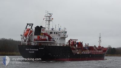
STOLT GREENSHANK
Oil/Chemical Tanker
Current Trip
| Time Travelled | 1 day |
|---|---|
| Remaining Time | 1 day |
| Distance Travelled | 291.29 nm |
| Remaining Distance | 419.22 nm |
| AVG Speed | 7.6 Knots |
| MAX Speed | 13.8 Knots |
| AVG Wind | 17.2 knots |
| MAX Wind | 19.6 knots |
| MIN Temp | 12.2°C / 53.96°F |
| MAX Temp | 15.1°C / 59.18°F |
| Draught | 5.4 m |
| Position Received | 1 m ago |
Current Position
| Longitude | 16.33402° |
|---|---|
| Latitude | 55.72046° |
| Status | Under way using engine |
| Speed | 12 Knots |
| Course | 77.1° |
| Area | Baltic Sea |
| Station | T-AIS |
| Position Received | 1 m ago |
Info
Information
The current position of STOLT GREENSHANK is in Baltic Sea with coordinates 55.72046° / 16.33402° as reported on 2024-06-06 23:05 by AIS to our vessel tracker app. The vessel's current speed is 12 Knots and is heading at the port of PORVOO. The estimated time of arrival as calculated by vessel tracking app is 2024-06-08 10:08 LT
The vessel STOLT GREENSHANK (IMO: 9518799, MMSI: 235096859) is a Oil/Chemical Tanker that was built in 2011 ( 13 years old ). It's sailing under the flag of [GB] United Kingdom.
In this page you can find informations about the vessels current position, last detected port calls, and current voyage information. If the vessels is not in coverage by AIS you will find the latest position.
The current position of STOLT GREENSHANK is detected by our AIS receivers and we are not responsible for the reliability of the data. The last position was recorded while the vessel was in Coverage by the Ais receivers of our vessel tracking app.
The current draught of STOLT GREENSHANK as reported by AIS is 5.4 meters
Weather
| Temperature | 12.8°C / 55.04°F |
|---|---|
| Wind Speed | 12 knots |
| Direction | 236° SW |
| Pressure | 1016.2 hPa |
| Humidity | 79.4 % |
| Cloud Coverage | 78 % |
Featured Company
Last Port Calls
| Port | Arrival | Departure | Time In Port |
|---|---|---|---|
| 2024-06-04 12:41 | 2024-06-05 10:11 | 21 h | |
| 2024-06-02 14:57 | 2024-06-02 15:54 | 57 m | |
| 2024-06-01 05:11 | 2024-06-01 05:36 | 24 m | |
| 2024-05-29 01:41 | 2024-05-29 01:44 | 3 m | |
| 2024-05-26 15:13 | 2024-05-27 13:25 | 22 h | |
| 2024-05-24 07:55 | 2024-05-25 08:37 | 1 d | |
| 2024-05-20 15:57 | 2024-05-22 00:19 | 1 d | |
| 2024-05-18 03:31 | 2024-05-19 00:10 | 20 h | |
| 2024-05-16 06:46 | 2024-05-17 05:03 | 22 h | |
| 2024-05-15 07:46 | 2024-05-15 08:55 | 1 h |
Last Trips
| Origin | Departure | Destination | Arrival | Distance | |
|---|---|---|---|---|---|
| 2024-06-02 17:54 | 2024-06-04 14:41 | 448.88 nm | |||
| 2024-06-01 07:36 | 2024-06-02 16:57 | 131.45 nm | |||
| 2024-05-29 03:44 | 2024-06-01 07:11 | 471.43 nm | |||
| 2024-05-27 15:25 | 2024-05-29 03:41 | 328.67 nm | |||
| 2024-05-25 09:37 | 2024-05-26 17:13 | 274.97 nm | |||
| 2024-05-22 02:19 | 2024-05-24 08:55 | 409.24 nm | |||
| 2024-05-19 01:10 | 2024-05-20 17:57 | 403.84 nm | |||
| 2024-05-17 06:03 | 2024-05-18 04:31 | 130.24 nm | |||
| 2024-05-15 10:55 | 2024-05-16 07:46 | 216.41 nm | |||
| 2024-05-15 09:02 | 2024-05-15 09:46 | 2.37 nm |
Events
| Time | Event | Details | Position / Dest | Info |
|---|---|---|---|---|
| 2024-06-06 20:34 | Change Sea Area | Swedish part of the Baltic Sea Danish part of the Kattegat |
55.59953 / 15.46937
Baltic Sea
FI PRV
|
Speed: 11.8 kn Course: 76.3° |
| 2024-06-06 16:22 | Change Sea Area | Danish part of the Kattegat Swedish part of the Baltic Sea |
55.15604 / 14.25849
Kattegat
FI PRV
|
Speed: 12.3 kn Course: 73.1° |
| 2024-06-06 11:47 | Change Sea Area | Swedish part of the Baltic Sea Danish part of the Baltic Sea |
55.29516 / 12.65696
Baltic Sea
FI PRV
|
Speed: 11.9 kn Course: 112.2° |
| 2024-06-06 11:35 | Change Sea Area | Danish part of the Baltic Sea Danish part of the Kattegat |
55.32332 / 12.62660
Baltic Sea
FI PRV
|
Speed: 11.8 kn Course: 189.8° |
| 2024-06-06 11:28 | Change Sea Area | Danish part of the Kattegat Swedish part of the Kattegat |
55.34602 / 12.63421
Kattegat
FI PRV
|
Speed: 11.8 kn Course: 191° |
| 2024-06-06 10:47 | Change Sea Area | Swedish part of the Kattegat Danish part of the Kattegat |
55.47266 / 12.69282
Kattegat
FI PRV
|
Speed: 11.7 kn Course: 200.9° |
| 2024-06-06 10:32 | Change Sea Area | Danish part of the Kattegat Swedish part of the Kattegat |
55.50626 / 12.70482
Kattegat
FI PRV
|
Speed: 8.3 kn Course: 237.2° |
| 2024-06-06 07:35 | Change Sea Area | Swedish part of the Kattegat Danish part of the Kattegat |
56.01456 / 12.66255
Kattegat
FI PRV
|
Speed: 13.4 kn Course: 162.1° |
| 2024-06-06 06:34 | ETA Changed | 2024/06/08 17:00 2024/06/08 04:00 |
56.15763 / 12.43144
FI PRV
|
Speed: 9.9 kn Course: 133.7° |
| 2024-06-06 06:14 | Change Sea Area | Danish part of the Kattegat Swedish part of the Kattegat |
56.19932 / 12.38594
Kattegat
FI PRV
|
Speed: 8.6 kn Course: 160° |