
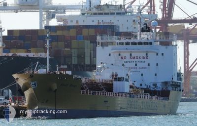
STOLT RENGE
Tanker C
Current Trip
TANJUNG BAKAU ID
| Time Travelled | 20 days |
|---|---|
| Remaining Time | --- |
| Distance Travelled | 3743.61 nm |
| Remaining Distance | --- |
| AVG Speed | 11.8 Knots |
| MAX Speed | 15 Knots |
| AVG Wind | 8.5 knots |
| MAX Wind | 23.8 knots |
| MIN Temp | 15.7°C / 60.26°F |
| MAX Temp | 31°C / 87.8°F |
| Draught | 5.9 m |
| Position Received | 9 d ago |
Current Position
| Longitude | 104.20590° |
|---|---|
| Latitude | 1.26497° |
| Status | Under way using engine |
| Speed | 13.5 Knots |
| Course | 81.8° |
| Area | Singapore Strait |
| Station | T-AIS |
| Position Received | 9 d ago |
Info
Information
The current position of STOLT RENGE is in Singapore Strait with coordinates 1.26497° / 104.20590° as reported on 2024-05-14 10:22 by AIS to our vessel tracker app. The vessel's current speed is 13.5 Knots
The vessel STOLT RENGE (IMO: 9781126, MMSI: 563206400) is a Tanker C It's sailing under the flag of [SG] Singapore.
In this page you can find informations about the vessels current position, last detected port calls, and current voyage information. If the vessels is not in coverage by AIS you will find the latest position.
The current position of STOLT RENGE is detected by our AIS receivers and we are not responsible for the reliability of the data. The last position was recorded while the vessel was in Coverage by the Ais receivers of our vessel tracking app.
The current draught of STOLT RENGE as reported by AIS is 5.9 meters
Weather
| Temperature | 24.2°C / 75.56°F |
|---|---|
| Wind Speed | 2 knots |
| Direction | 112° ESE |
| Pressure | 1009 hPa |
| Humidity | 98.8 % |
| Cloud Coverage | 100 % |
Featured Company
Last Port Calls
| Port | Arrival | Departure | Time In Port |
|---|---|---|---|
| 2024-04-30 11:00 | 2024-05-03 01:28 | 2 d | |
| 2024-04-11 07:49 | 2024-04-11 22:04 | 14 h | |
| 2024-04-05 08:28 | 2024-04-06 10:01 | 1 d | |
| 2024-04-02 10:25 | 2024-04-04 03:49 | 1 d | |
| 2024-03-26 22:46 | 2024-03-27 20:14 | 21 h | |
| 2024-03-24 18:13 | 2024-03-26 06:31 | 1 d | |
| 2024-03-18 02:37 | 2024-03-19 04:35 | 1 d | |
| 2024-03-14 11:25 | 2024-03-15 05:10 | 17 h |
Most Visited Ports (Last year)
| Port | Arrivals | |
|---|---|---|
| 6 | ||
| 3 | ||
| 2 | ||
| 2 | ||
| 1 | ||
| 1 |
Last Trips
| Origin | Departure | Destination | Arrival | Distance | |
|---|---|---|---|---|---|
| 2024-04-12 06:04 | 2024-04-30 19:00 | 3505.14 nm | |||
| 2024-04-06 18:01 | 2024-04-11 15:49 | 1497.70 nm | |||
| 2024-04-04 10:49 | 2024-04-05 16:28 | 208.51 nm | |||
| 2024-03-28 04:14 | 2024-04-02 17:25 | 742.55 nm | |||
| 2024-03-26 14:31 | 2024-03-27 06:46 | 15.16 nm | |||
| 2024-03-19 12:35 | 2024-03-25 02:13 | 1698.43 nm | |||
| 2024-03-15 14:10 | 2024-03-18 10:37 | 862.28 nm | |||
| 2024-02-28 16:03 | 2024-03-14 20:25 | 3865.31 nm |
Events
| Time | Event | Details | Position / Dest | Info |
|---|---|---|---|---|
| 2024-05-21 08:08 | STOP Moving |
-1.13333 / 119.38834
TANJUNG BAKAU ID
|
Speed: Course: -1° |
|
| 2024-05-21 07:51 | START Moving |
-1.12514 / 119.39066
TANJUNG BAKAU ID
|
Speed: 3.2 kn Course: 203° |
|
| 2024-05-19 07:19 | START Moving |
-1.14286 / 119.32894
TANJUNG BAKAU ID
|
Speed: 6.3 kn Course: 62° |
|
| 2024-05-18 22:35 | STOP Moving |
-1.13333 / 119.31667
TANJUNG BAKAU ID
|
Speed: Course: -1° |
|
| 2024-05-14 10:28 | Status Changed | Default Under way using engine |
1.26747 / 104.22691
TANJUNG BAKAU ID
|
Speed: 13.5 kn Course: 81.8° |
| 2024-05-14 10:22 | OUT of Coverage |
1.26497 / 104.20590
Singapore Strait
TANJUNG BAKAU ID
|
Speed: 13.5 kn Course: 81.8° |
|
| 2024-05-14 10:13 | Change Sea Area | Malaysian part of the Singapore Strait Indonesian part of the Singapore Strait |
1.26042 / 104.17393
Singapore Strait
TANJUNG BAKAU ID
|
Speed: 13.9 kn Course: 82.3° |
| 2024-05-14 10:13 | Status Changed | Under way using engine Default |
1.25998 / 104.17070
TANJUNG BAKAU ID
|
Speed: 13.8 kn Course: 82° |
| 2024-05-14 10:01 | Status Changed | Default Under way using engine |
1.25369 / 104.12524
TANJUNG BAKAU ID
|
Speed: 13.3 kn Course: 82.7° |
| 2024-05-14 08:29 | Change Sea Area | Indonesian part of the Singapore Strait Singaporean part of the Singapore Strait |
1.17327 / 103.81293
Singapore Strait
TANJUNG BAKAU ID
|
Speed: 11.2 kn Course: 76.3° |