
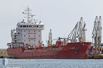
SUDE-S
Oil/Chemical Tanker
Current Trip
| Time Travelled | 5 days |
|---|---|
| Remaining Time | --- |
| Distance Travelled | 212.39 nm |
| Remaining Distance | --- |
| AVG Speed | 9.9 Knots |
| MAX Speed | 14.3 Knots |
| AVG Wind | 12.5 knots |
| MAX Wind | 23.9 knots |
| MIN Temp | 11.8°C / 53.24°F |
| MAX Temp | 16°C / 60.8°F |
| Draught | 5 m |
| Position Received | 1 m ago |
Current Position
| Longitude | 2.52857° |
|---|---|
| Latitude | 51.33687° |
| Status | Under way using engine |
| Speed | |
| Course | 248° |
| Area | North Sea |
| Station | T-AIS |
| Position Received | 1 m ago |
Info
Information
The current position of SUDE-S is in North Sea with coordinates 51.33687° / 2.52857° as reported on 2024-06-06 15:08 by AIS to our vessel tracker app. The vessel's current speed is 0 Knots
The vessel SUDE-S (IMO: 9508378, MMSI: 215516000) is a Oil/Chemical Tanker that was built in 2009 ( 15 years old ). It's sailing under the flag of [MT] Malta.
In this page you can find informations about the vessels current position, last detected port calls, and current voyage information. If the vessels is not in coverage by AIS you will find the latest position.
The current position of SUDE-S is detected by our AIS receivers and we are not responsible for the reliability of the data. The last position was recorded while the vessel was in Coverage by the Ais receivers of our vessel tracking app.
The current draught of SUDE-S as reported by AIS is 5 meters
Weather
| Temperature | 14.2°C / 57.56°F |
|---|---|
| Wind Speed | 11 knots |
| Direction | 258° WSW |
| Pressure | 1017.8 hPa |
| Humidity | 66.6 % |
| Cloud Coverage | 33 % |
Featured Company
Last Port Calls
| Port | Arrival | Departure | Time In Port |
|---|---|---|---|
| 2024-05-31 18:13 | 2024-06-01 11:35 | 17 h | |
| 2024-05-28 03:09 | 2024-05-28 21:55 | 18 h | |
| 2024-05-25 00:57 | 2024-05-26 08:34 | 1 d | |
| 2024-05-19 02:50 | 2024-05-19 13:03 | 10 h | |
| 2024-05-16 21:05 | 2024-05-18 09:04 | 1 d | |
| 2024-05-13 00:57 | 2024-05-15 17:51 | 2 d | |
| 2024-05-10 13:11 | 2024-05-11 08:54 | 19 h | |
| 2024-05-08 02:03 | 2024-05-09 08:58 | 1 d | |
| 2024-05-07 14:54 | 2024-05-08 00:44 | 9 h | |
| 2024-05-03 12:22 | 2024-05-04 00:15 | 11 h |
Most Visited Ports (Last year)
| Port | Arrivals | |
|---|---|---|
| 10 | ||
| 5 | ||
| 4 | ||
| 4 | ||
| 3 | ||
| 3 |
Last Trips
| Origin | Departure | Destination | Arrival | Distance | |
|---|---|---|---|---|---|
| 2024-05-28 23:55 | 2024-05-31 20:13 | 54.36 nm | |||
| 2024-05-26 10:34 | 2024-05-28 05:09 | 293.23 nm | |||
| 2024-05-19 15:03 | 2024-05-25 02:57 | 524.88 nm | |||
| 2024-05-18 10:04 | 2024-05-19 04:50 | 202.10 nm | |||
| 2024-05-15 19:51 | 2024-05-16 22:05 | 247.07 nm | |||
| 2024-05-11 10:54 | 2024-05-13 02:57 | 425.19 nm | |||
| 2024-05-09 10:58 | 2024-05-10 15:11 | 309.36 nm | |||
| 2024-05-08 02:44 | 2024-05-08 04:03 | 11.65 nm | |||
| 2024-05-04 02:15 | 2024-05-07 16:54 | 1002.87 nm | |||
| 2024-04-28 13:12 | 2024-05-03 14:22 | 1091.48 nm |
Events
| Time | Event | Details | Position / Dest | Info |
|---|---|---|---|---|
| 2024-06-02 08:16 | STOP Moving | 14.76 nm, North West of NIEUWPOORT |
51.33543 / 2.52677
BEANR
|
Speed: 0.3 kn Course: 303° |
| 2024-06-02 07:19 | Change Sea Area | Belgian part of the North Sea French part of the North Sea |
51.32954 / 2.36805
North Sea
|
Speed: 11.7 kn Course: 63.8° |
| 2024-06-02 03:47 | Detected in Sea | French part of the North Sea |
51.01758 / 1.60446
North Sea
|
Speed: 8.7 kn Course: 42.2° |
| 2024-06-01 22:42 | Detected in Sea | French part of the English Channel |
50.49056 / .91624
English Channel
|
Speed: 9.7 kn Course: 70.8° |
| 2024-06-01 22:42 | Status Changed | Under way using engine Default |
50.49056 / .91624
BEANR
|
Speed: 9.8 kn Course: 70° |
| 2024-06-01 22:38 | Status Changed | Default Under way using engine |
50.48747 / .90226
BEANR
|
Speed: 9.7 kn Course: 70.9° |
| 2024-06-01 22:28 | Status Changed | Under way using engine Default |
50.47861 / .86236
BEANR
|
Speed: 9.7 kn Course: 71° |
| 2024-06-01 22:18 | Status Changed | Default Under way using engine |
50.46972 / .82241
BEANR
|
Speed: 9.7 kn Course: 70.1° |
| 2024-06-01 22:12 | Status Changed | Under way using engine Default |
50.46462 / .79980
BEANR
|
Speed: 9.7 kn Course: 71° |
| 2024-06-01 22:06 | Status Changed | Default Under way using engine |
50.45902 / .77443
BEANR
|
Speed: 9.8 kn Course: 71.1° |