
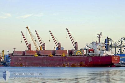
SWEET LADY III
Bulk Carrier
Current Trip
KEMAMAN
| Time Travelled | 2 days |
|---|---|
| Remaining Time | --- |
| Distance Travelled | 478.58 nm |
| Remaining Distance | --- |
| AVG Speed | 11.8 Knots |
| MAX Speed | 16.4 Knots |
| AVG Wind | 10 knots |
| MAX Wind | 15.9 knots |
| MIN Temp | 26.1°C / 78.98°F |
| MAX Temp | 31.1°C / 87.98°F |
| Draught | 12.6 m |
| Position Received | 14 d ago |
Current Position
| Longitude | 119.82878° |
|---|---|
| Latitude | 23.55074° |
| Status | Under way using engine |
| Speed | 10.6 Knots |
| Course | 177.5° |
| Area | South China Sea |
| Station | T-AIS |
| Position Received | 14 d ago |
Info
Information
The current position of SWEET LADY III is in South China Sea with coordinates 23.55074° / 119.82878° as reported on 2024-05-18 17:43 by AIS to our vessel tracker app. The vessel's current speed is 10.6 Knots
The vessel SWEET LADY III (IMO: 9316804, MMSI: 248256000) is a Bulk Carrier that was built in 2006 ( 18 years old ). It's sailing under the flag of [MT] Malta.
In this page you can find informations about the vessels current position, last detected port calls, and current voyage information. If the vessels is not in coverage by AIS you will find the latest position.
The current position of SWEET LADY III is detected by our AIS receivers and we are not responsible for the reliability of the data. The last position was recorded while the vessel was in Coverage by the Ais receivers of our vessel tracking app.
The current draught of SWEET LADY III as reported by AIS is 12.6 meters
Weather
| Temperature | 28.5°C / 83.3°F |
|---|---|
| Wind Speed | 8 knots |
| Direction | 135° SE |
| Pressure | 1011.4 hPa |
| Humidity | 79 % |
| Cloud Coverage | 100 % |
Featured Company
Last Port Calls
| Port | Arrival | Departure | Time In Port |
|---|---|---|---|
| 2024-05-26 04:32 | 2024-05-30 05:06 | 4 d | |
| 2024-05-12 06:49 | 2024-05-13 14:19 | 1 d | |
| 2024-05-06 03:24 |
Most Visited Ports (Last year)
| Port | Arrivals | |
|---|---|---|
| 4 | ||
| 3 | ||
| 2 | ||
| 1 | ||
| 1 | ||
| 1 |
Last Trips
| Origin | Departure | Destination | Arrival | Distance | |
|---|---|---|---|---|---|
| 2024-05-14 00:19 | 2024-05-26 12:32 | 2892.93 nm | |||
| 2024-05-06 11:24 | 2024-05-12 16:49 | 1255.59 nm |
Events
| Time | Event | Details | Position / Dest | Info |
|---|---|---|---|---|
| 2024-05-31 09:26 | START Moving | 5.99 nm, East of KEMAMAN |
4.21838 / 103.56126
KEMAMAN
|
Speed: 3.3 kn Course: 202° |
| 2024-05-30 05:54 | STOP Moving | 6.05 nm, East of KEMAMAN |
4.21962 / 103.56278
KEMAMAN
|
Speed: 0.2 kn Course: 108° |
| 2024-05-30 05:06 | PORT DEPARTURE |
|
4.24199 / 103.47186
KEMAMAN
|
Speed: 5.3 kn Course: 149° |
| 2024-05-30 05:02 | START Moving |
4.24759 / 103.46853
[MY] KEMAMAN
|
Speed: 5.3 kn Course: 149° |
|
| 2024-05-26 05:11 | STOP Moving |
4.25090 / 103.46873
[MY] KEMAMAN
|
Speed: 0.2 kn Course: 14° |
|
| 2024-05-26 04:32 | PORT ARRIVAL |
|
4.25091 / 103.46825
[MY] KEMAMAN
|
Speed: 5.6 kn Course: 312° |
| 2024-05-26 03:08 | START Moving | 6 nm, East of KEMAMAN |
4.22917 / 103.56425
KEMAMAN
|
Speed: 3.5 kn Course: 170° |
| 2024-05-24 03:21 | STOP Moving | 5.75 nm, East of KEMAMAN |
4.23048 / 103.56017
KEMAMAN
|
Speed: 0.2 kn Course: 11° |