
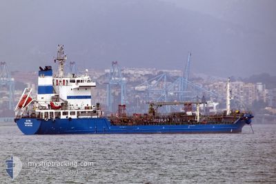
SYMI
Tanker
Current Trip
| Time Travelled | 20 h, 8 mins |
|---|---|
| Remaining Time | --- |
| Distance Travelled | 31.80 nm |
| Remaining Distance | --- |
| AVG Speed | 7.3 Knots |
| MAX Speed | 10 Knots |
| AVG Wind | 10 knots |
| MAX Wind | 18.8 knots |
| MIN Temp | 14.8°C / 58.64°F |
| MAX Temp | 23.4°C / 74.12°F |
| Draught | 6.4 m |
| Position Received | 1 h, 1 m ago |
Current Position
| Longitude | -5.54235° |
|---|---|
| Latitude | 35.86074° |
| Status | Moored |
| Speed | |
| Course | 219° |
| Area | Strait of Gibraltar |
| Station | T-AIS |
| Position Received | 1 h, 1 m ago |
Info
Information
The current position of SYMI is in Strait of Gibraltar with coordinates 35.86074° / -5.54235° as reported on 2024-06-17 18:46 by AIS to our vessel tracker app. The vessel's current speed is 0 Knots
The vessel SYMI (IMO: 9418016, MMSI: 236717000) is a Tanker It's sailing under the flag of [GI] Gibraltar.
In this page you can find informations about the vessels current position, last detected port calls, and current voyage information. If the vessels is not in coverage by AIS you will find the latest position.
The current position of SYMI is detected by our AIS receivers and we are not responsible for the reliability of the data. The last position was recorded while the vessel was in Coverage by the Ais receivers of our vessel tracking app.
The current draught of SYMI as reported by AIS is 6.4 meters
Weather
| Temperature | 21.4°C / 70.52°F |
|---|---|
| Wind Speed | 5 knots |
| Direction | 279° W |
| Pressure | 1012.6 hPa |
| Humidity | 56.8 % |
| Cloud Coverage | --- |
Featured Company
Last Port Calls
| Port | Arrival | Departure | Time In Port |
|---|---|---|---|
| 2024-06-16 21:57 | 2024-06-16 23:39 | 1 h | |
| 2024-06-16 05:38 | 2024-06-16 16:48 | 11 h | |
| 2024-06-15 22:36 | 2024-06-16 01:19 | 2 h | |
| 2024-06-14 20:28 | 2024-06-15 03:45 | 7 h | |
| 2024-06-14 06:34 | 2024-06-14 11:36 | 5 h | |
| 2024-06-12 23:16 | 2024-06-13 07:58 | 8 h | |
| 2024-06-11 09:12 | 2024-06-12 09:52 | 1 d | |
| 2024-06-10 09:59 | 2024-06-10 23:42 | 13 h | |
| 2024-06-09 01:00 | 2024-06-09 12:45 | 11 h | |
| 2024-06-08 12:27 | 2024-06-08 15:55 | 3 h |
Most Visited Ports (Last year)
| Port | Arrivals | |
|---|---|---|
| 171 | ||
| 109 | ||
| 10 | ||
| 6 |
Last Trips
| Origin | Departure | Destination | Arrival | Distance | |
|---|---|---|---|---|---|
| 2024-06-16 18:48 | 2024-06-16 23:57 | 3.14 nm | |||
| 2024-06-16 03:19 | 2024-06-16 07:38 | 5.52 nm | |||
| 2024-06-15 04:45 | 2024-06-16 00:36 | 24.04 nm | |||
| 2024-06-14 12:36 | 2024-06-14 21:28 | 10.89 nm | |||
| 2024-06-13 08:58 | 2024-06-14 07:34 | 52.03 nm | |||
| 2024-06-12 11:52 | 2024-06-13 00:16 | 24.23 nm | |||
| 2024-06-11 00:42 | 2024-06-11 11:12 | 25.78 nm | |||
| 2024-06-09 14:45 | 2024-06-10 10:59 | 24.60 nm | |||
| 2024-06-08 17:55 | 2024-06-09 03:00 | 3.77 nm | |||
| 2024-06-08 13:56 | 2024-06-08 14:27 | 1.76 nm |
Events
| Time | Event | Details | Position / Dest | Info |
|---|---|---|---|---|
| 2024-06-17 18:49 | Status Changed | Default Moored |
35.86073 / -5.54245
TANGER MED
|
Speed: Course: 219° |
| 2024-06-17 18:46 | Status Changed | Moored Default |
35.86074 / -5.54235
TANGER MED
|
Speed: Course: 219° |
| 2024-06-17 18:25 | Status Changed | Default Moored |
35.86076 / -5.54243
TANGER MED
|
Speed: 0.1 kn Course: 218° |
| 2024-06-17 18:19 | Status Changed | Moored Under way using engine |
35.86081 / -5.54242
TANGER MED
|
Speed: 0.1 kn Course: 216° |
| 2024-06-17 18:08 | STOP Moving | 1.64 nm, South West of TANGER MED |
35.86090 / -5.54262
TANGER MED
|
Speed: 0.3 kn Course: 213° |
| 2024-06-17 17:07 | Change Sea Area | Moroccan part of the Strait of Gibraltar Spanish part of the Strait of Gibraltar |
35.96898 / -5.49045
Strait of Gibraltar
TANGER MED
|
Speed: 7.8 kn Course: 240.9° |
| 2024-06-17 16:02 | Change Sea Area | Spanish part of the Strait of Gibraltar Gibraltarian part of the Strait of Gibraltar |
36.05183 / -5.36033
Strait of Gibraltar
TANGER MED
|
Speed: 7.2 kn Course: 225.5° |
| 2024-06-17 15:50 | Change Sea Area | Gibraltarian part of the Strait of Gibraltar Gibraltarian part of the Alboran Sea |
36.07008 / -5.33350
Strait of Gibraltar
TANGER MED
|
Speed: 8 kn Course: 229.5° |
| 2024-06-17 15:11 | START Moving | 2.82 nm, East of GIBRALTAR |
36.13096 / -5.30826
TANGER MED
|
Speed: 3.9 kn Course: 206° |
| 2024-06-17 14:48 | Status Changed | Under way using engine At anchor |
36.13464 / -5.30529
TANGER MED
|
Speed: Course: 228° |