
SZARE SZEREGI
Cargo
Current Trip
| Time Travelled | 10 days |
|---|---|
| Remaining Time | --- |
| Distance Travelled | 3086.15 nm |
| Remaining Distance | --- |
| AVG Speed | 11.7 Knots |
| MAX Speed | 14.7 Knots |
| AVG Wind | 11.9 knots |
| MAX Wind | 30 knots |
| MIN Temp | 11.3°C / 52.34°F |
| MAX Temp | 22.4°C / 72.32°F |
| Draught | 9.6 m |
| Position Received | 5 d ago |
Current Position
| Longitude | -4.82108° |
|---|---|
| Latitude | 49.27183° |
| Status | Under way using engine |
| Speed | 13.3 Knots |
| Course | 238.4° |
| Area | English Channel |
| Station | T-AIS |
| Position Received | 5 d ago |
Info
Information
The current position of SZARE SZEREGI is in English Channel with coordinates 49.27183° / -4.82108° as reported on 2024-05-31 18:28 by AIS to our vessel tracker app. The vessel's current speed is 13.3 Knots and is heading at the port of RIO GRANDE. The estimated time of arrival as calculated by vessel tracking app is 2024-06-21 09:00 LT
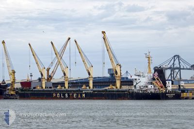
The vessel SZARE SZEREGI (IMO: 9708057, MMSI: 636017072) is a Cargo It's sailing under the flag of [LR] Liberia.
In this page you can find informations about the vessels current position, last detected port calls, and current voyage information. If the vessels is not in coverage by AIS you will find the latest position.
The current position of SZARE SZEREGI is detected by our AIS receivers and we are not responsible for the reliability of the data. The last position was recorded while the vessel was in Coverage by the Ais receivers of our vessel tracking app.
The current draught of SZARE SZEREGI as reported by AIS is 9.6 meters
Weather
| Temperature | 22.4°C / 72.32°F |
|---|---|
| Wind Speed | 8 knots |
| Direction | --- N |
| Pressure | 1019.6 hPa |
| Humidity | 72.9 % |
| Cloud Coverage | 61 % |
Featured Company
Last Port Calls
| Port | Arrival | Departure | Time In Port |
|---|---|---|---|
| 2024-05-22 05:09 | 2024-05-26 21:59 | 4 d | |
| 2024-05-12 20:27 | 2024-05-16 23:41 | 4 d | |
| 2024-04-25 09:11 | 2024-04-27 16:59 | 2 d | |
| 2024-04-11 08:19 | 2024-04-13 21:55 | 2 d | |
| 2024-04-08 11:44 | 2024-04-09 17:28 | 1 d | |
| 2024-04-05 10:11 | 2024-04-05 22:07 | 11 h |
Most Visited Ports (Last year)
| Port | Arrivals | |
|---|---|---|
| 3 | ||
| 2 | ||
| 2 | ||
| 2 | ||
| 2 | ||
| 2 |
Last Trips
| Origin | Departure | Destination | Arrival | Distance | |
|---|---|---|---|---|---|
| 2024-05-17 00:41 | 2024-05-22 08:09 | 1093.60 nm | |||
| 2024-04-27 12:59 | 2024-05-12 21:27 | 4112.50 nm | |||
| 2024-04-13 17:55 | 2024-04-25 05:11 | 598.11 nm | |||
| 2024-04-09 13:28 | 2024-04-11 04:19 | 402.69 nm | |||
| 2024-04-05 18:07 | 2024-04-08 07:44 | 719.72 nm | |||
| 2024-03-21 09:32 | 2024-04-05 06:11 | 3803.18 nm |
Events
| Time | Event | Details | Position / Dest | Info |
|---|---|---|---|---|
| 2024-05-31 18:34 | Status Changed | Default Under way using engine |
49.26143 / -4.84567
BRRIG
|
Speed: 13.3 kn Course: 238.4° |
| 2024-05-31 18:28 | OUT of Coverage |
49.27183 / -4.82108
English Channel
BRRIG
|
Speed: 13.3 kn Course: 238.4° |
|
| 2024-05-31 17:27 | Change Sea Area | French part of the English Channel United Kingdom part of the English Channel |
49.38892 / -4.51718
English Channel
BRRIG
|
Speed: 13.5 kn Course: 239.5° |
| 2024-05-31 17:27 | Status Changed | Under way using engine Default |
49.38952 / -4.51560
BRRIG
|
Speed: 13.4 kn Course: 240° |
| 2024-05-31 17:21 | IN Coverage |
49.38892 / -4.51718
English Channel
BRRIG
|
Speed: 13.5 kn Course: 239.5° |
|
| 2024-05-31 16:12 | Status Changed | Default Under way using engine |
49.52939 / -4.14959
BRRIG
|
Speed: 12.7 kn Course: 251.6° |
| 2024-05-31 16:05 | OUT of Coverage |
49.54193 / -4.11420
English Channel
BRRIG
|
Speed: 12.7 kn Course: 251.6° |
|
| 2024-05-31 14:59 | ETA Changed | 2024/06/21 09:00 2024/06/21 18:00 |
49.65102 / -3.79818
BRRIG
|
Speed: 12.5 kn Course: 239.1° |
| 2024-05-31 14:53 | Status Changed | Under way using engine Default |
49.66152 / -3.77079
BRRIG
|
Speed: 12.3 kn Course: 239° |
| 2024-05-31 14:47 | IN Coverage |
49.65689 / -3.78285
English Channel
BRRIG
|
Speed: 12.4 kn Course: 239.4° |