
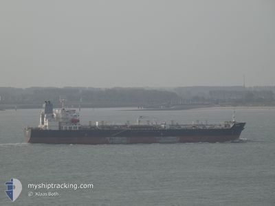
TAURUS
Oil/Chemical Tanker
Current Trip
TRMER
| Time Travelled | 24 days |
|---|---|
| Remaining Time | --- |
| Distance Travelled | 5027.56 nm |
| Remaining Distance | --- |
| AVG Speed | 11.4 Knots |
| MAX Speed | 11.4 Knots |
| AVG Wind | 12.4 knots |
| MAX Wind | 26.8 knots |
| MIN Temp | -0.1°C / 31.82°F |
| MAX Temp | 26°C / 78.8°F |
| Draught | 11.9 m |
| Position Received | 1 m ago |
Current Position
| Longitude | 35.49081° |
|---|---|
| Latitude | 33.81826° |
| Status | Moored |
| Speed | |
| Course | 201° |
| Area | Mediterranean Sea - Eastern Basin |
| Station | T-AIS |
| Position Received | 1 m ago |
Info
Information
The current position of TAURUS is in Mediterranean Sea - Eastern Basin with coordinates 33.81826° / 35.49081° as reported on 2024-06-01 22:15 by AIS to our vessel tracker app. The vessel's current speed is 0 Knots
The vessel TAURUS (IMO: 9417206, MMSI: 636014088) is a Oil/Chemical Tanker that was built in 2009 ( 15 years old ). It's sailing under the flag of [LR] Liberia.
In this page you can find informations about the vessels current position, last detected port calls, and current voyage information. If the vessels is not in coverage by AIS you will find the latest position.
The current position of TAURUS is detected by our AIS receivers and we are not responsible for the reliability of the data. The last position was recorded while the vessel was in Coverage by the Ais receivers of our vessel tracking app.
The current draught of TAURUS as reported by AIS is 11.9 meters
Weather
| Temperature | 21.8°C / 71.24°F |
|---|---|
| Wind Speed | 6 knots |
| Direction | 18° NNE |
| Pressure | 1015.9 hPa |
| Humidity | 66.9 % |
| Cloud Coverage | --- |
Featured Company
Last Trips
| Origin | Departure | Destination | Arrival | Distance | |
|---|---|---|---|---|---|
| 2024-04-26 16:30 | 2024-05-06 23:27 | 1519.55 nm | |||
| 2024-04-20 02:10 | 2024-04-24 01:58 | 809.39 nm | |||
| 2024-04-07 07:07 | 2024-04-17 21:51 | 2337.46 nm | |||
| 2024-04-04 11:23 | 2024-04-05 23:49 | 273.87 nm | |||
| 2024-03-29 18:58 | 2024-04-02 10:39 | 230.53 nm |
Events
| Time | Event | Details | Position / Dest | Info |
|---|---|---|---|---|
| 2024-06-01 22:13 | STOP Moving | 6.14 nm, South of BEIRUT |
33.81826 / 35.49082
TRMER
|
Speed: Course: 201° |
| 2024-06-01 22:12 | IN Coverage |
33.81826 / 35.49082
Mediterranean Sea - Eastern Basin
|
Speed: Course: 238.4° |
|
| 2024-06-01 20:23 | OUT of Coverage |
33.81824 / 35.49082
Mediterranean Sea - Eastern Basin
|
Speed: Course: 257.9° |
|
| 2024-06-01 20:10 | IN Coverage |
33.81826 / 35.49081
Mediterranean Sea - Eastern Basin
|
Speed: Course: 328° |
|
| 2024-06-01 18:48 | OUT of Coverage |
33.81827 / 35.49081
Mediterranean Sea - Eastern Basin
|
Speed: Course: 201° |
|
| 2024-06-01 18:44 | IN Coverage |
33.81827 / 35.49081
Mediterranean Sea - Eastern Basin
|
Speed: Course: 72.8° |
|
| 2024-06-01 16:41 | OUT of Coverage |
33.81824 / 35.49080
Mediterranean Sea - Eastern Basin
|
Speed: Course: 187.2° |
|
| 2024-06-01 16:31 | IN Coverage |
33.81826 / 35.49080
Mediterranean Sea - Eastern Basin
|
Speed: Course: 180.5° |
|
| 2024-06-01 15:44 | ETA Changed | 2025/05/25 18:00 2024/05/25 18:00 |
36.70443 / 34.72254
TRMER
|
Speed: 13.7 kn Course: 66° |
| 2024-05-31 12:34 | OUT of Coverage |
36.70434 / 34.72262
Mediterranean Sea - Eastern Basin
|
Speed: Course: 147.7° |