
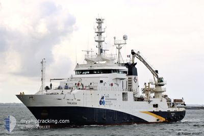
THALASSA
Fishery Research Vessel
Current Trip
Current Position
| Longitude | -4.47961° |
|---|---|
| Latitude | 48.38288° |
| Status | Moored |
| Speed | |
| Course | 256° |
| Area | Celtic Sea |
| Station | T-AIS |
| Position Received | 3 m ago |
Info
Information
The current position of THALASSA is in Celtic Sea with coordinates 48.38288° / -4.47961° as reported on 2024-06-01 04:58 by AIS to our vessel tracker app. The vessel's current speed is 0 Knots and is currently inside the port of BREST.
The vessel THALASSA (IMO: 9070307, MMSI: 227297000) is a Fishery Research Vessel that was built in 1995 ( 29 years old ). It's sailing under the flag of [FR] France.
In this page you can find informations about the vessels current position, last detected port calls, and current voyage information. If the vessels is not in coverage by AIS you will find the latest position.
The current position of THALASSA is detected by our AIS receivers and we are not responsible for the reliability of the data. The last position was recorded while the vessel was in Coverage by the Ais receivers of our vessel tracking app.
The current draught of THALASSA as reported by AIS is 5.8 meters
Weather
| Temperature | 10.9°C / 51.62°F |
|---|---|
| Wind Speed | 6 knots |
| Direction | 39° NE |
| Pressure | 1024.1 hPa |
| Humidity | 94.1 % |
| Cloud Coverage | 2 % |
Featured Company
Most Visited Ports (Last year)
| Port | Arrivals | |
|---|---|---|
| 13 | ||
| 3 | ||
| 3 | ||
| 1 | ||
| 1 | ||
| 1 |
Last Trips
| Origin | Departure | Destination | Arrival | Distance | |
|---|---|---|---|---|---|
| 2024-05-20 13:24 | 2024-05-27 13:08 | 629.84 nm | |||
| 2024-05-12 08:26 | 2024-05-20 12:35 | 965.09 nm | |||
| 2024-04-28 08:18 | 2024-05-11 07:21 | 1425.78 nm | |||
| 2024-04-20 09:16 | 2024-04-24 15:08 | 249.43 nm | |||
| 2024-02-17 09:27 | 2024-04-16 14:45 | 1294.59 nm |
Events
| Time | Event | Details | Position / Dest | Info |
|---|---|---|---|---|
| 2024-06-01 00:01 | ETA Changed | 2025/05/27 14:00 2024/05/27 14:00 |
48.38289 / -4.47961
[FR] BREST
|
Speed: Course: 257° |
| 2024-05-30 06:20 | Status Changed | Moored Under way using engine |
48.38289 / -4.47954
[FR] BREST
|
Speed: Course: 256° |
| 2024-05-30 05:35 | Status Changed | Under way using engine Moored |
48.38293 / -4.47942
[FR] BREST
|
Speed: Course: 75° |
| 2024-05-27 11:46 | Status Changed | Moored Under way using engine |
48.38293 / -4.47933
[FR] BREST
|
Speed: Course: 76° |
| 2024-05-27 11:30 | STOP Moving |
48.38276 / -4.47921
[FR] BREST
|
Speed: 0.3 kn Course: 75° |
|
| 2024-05-27 11:08 | PORT ARRIVAL |
|
48.36812 / -4.48890
[FR] BREST
|
Speed: 6.6 kn Course: 350.3° |
| 2024-05-27 08:36 | Status Changed | Under way using engine Engaged in Fishing |
48.18010 / -4.77527
FR BES
|
Speed: 6.2 kn Course: 39.3° |
| 2024-05-27 08:27 | START Moving | 8.28 nm, North of SEIN |
48.16847 / -4.78947
FR BES
|
Speed: 4.8 kn Course: 31° |
| 2024-05-27 08:23 | STOP Moving | 8.16 nm, North of SEIN |
48.16656 / -4.79029
FR BES
|
Speed: 0.2 kn Course: 308° |
| 2024-05-27 07:34 | Status Changed | Engaged in Fishing Under way using engine |
48.16641 / -4.80630
FR BES
|
Speed: 2.4 kn Course: 248° |