
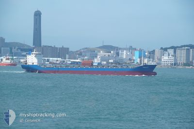
TIAN FU 2
Cargo
Current Trip
| Time Travelled | 4 days |
|---|---|
| Remaining Time | 2 h, 0 mins |
| Distance Travelled | 985.14 nm |
| Remaining Distance | 25.94 nm |
| AVG Speed | 10.1 Knots |
| MAX Speed | 12 Knots |
| AVG Wind | 9.5 knots |
| MAX Wind | 19.8 knots |
| MIN Temp | 13.2°C / 55.76°F |
| MAX Temp | 22.6°C / 72.68°F |
| Draught | 4.7 m |
| Position Received | 1 d ago |
Current Position
| Longitude | 125.73743° |
|---|---|
| Latitude | 33.83099° |
| Status | Under way using engine |
| Speed | 11.2 Knots |
| Course | 278.6° |
| Area | Yellow Sea |
| Station | T-AIS |
| Position Received | 1 d ago |
Info
Information
The current position of TIAN FU 2 is in Yellow Sea with coordinates 33.83099° / 125.73743° as reported on 2024-06-12 02:31 by AIS to our vessel tracker app. The vessel's current speed is 11.2 Knots and is heading at the port of QINGDAO. The estimated time of arrival as calculated by vessel tracking app is 2024-06-13 13:31 LT
The vessel TIAN FU 2 (IMO: 8671116, MMSI: 352002008) is a Cargo It's sailing under the flag of [PA] Panama.
In this page you can find informations about the vessels current position, last detected port calls, and current voyage information. If the vessels is not in coverage by AIS you will find the latest position.
The current position of TIAN FU 2 is detected by our AIS receivers and we are not responsible for the reliability of the data. The last position was recorded while the vessel was in Coverage by the Ais receivers of our vessel tracking app.
The current draught of TIAN FU 2 as reported by AIS is 4.7 meters
Weather
| Temperature | 20.8°C / 69.44°F |
|---|---|
| Wind Speed | 12 knots |
| Direction | 170° S |
| Pressure | 1002.2 hPa |
| Humidity | 90.8 % |
| Cloud Coverage | 1 % |
Featured Company
Last Port Calls
| Port | Arrival | Departure | Time In Port |
|---|---|---|---|
| 2024-06-07 04:59 | 2024-06-09 05:41 | 2 d | |
| 2024-05-29 10:17 | 2024-05-30 03:29 | 17 h | |
| 2024-05-20 22:29 | 2024-05-22 18:38 | 1 d | |
| 2024-05-13 06:16 | 2024-05-14 05:08 | 22 h | |
| 2024-05-07 02:03 | 2024-05-09 02:15 | 2 d | |
| 2024-04-27 09:48 | 2024-04-28 18:16 | 1 d | |
| 2024-04-22 08:11 | 2024-04-23 06:22 | 22 h | |
| 2024-04-11 00:50 | 2024-04-13 19:38 | 2 d | |
| 2024-04-02 10:19 | 2024-04-07 04:25 | 4 d |
Most Visited Ports (Last year)
| Port | Arrivals | |
|---|---|---|
| 5 | ||
| 4 | ||
| 4 |
Last Trips
| Origin | Departure | Destination | Arrival | Distance | |
|---|---|---|---|---|---|
| 2024-05-30 11:29 | 2024-06-07 14:59 | 1513.07 nm | |||
| 2024-05-23 04:38 | 2024-05-29 18:17 | 1046.97 nm | |||
| 2024-05-14 13:08 | 2024-05-21 08:29 | 1518.97 nm | |||
| 2024-05-09 12:15 | 2024-05-13 14:16 | 1002.40 nm | |||
| 2024-04-29 02:16 | 2024-05-07 12:03 | 1538.01 nm | |||
| 2024-04-23 16:22 | 2024-04-27 17:48 | 1022.88 nm | |||
| 2024-04-14 03:38 | 2024-04-22 18:11 | 1604.22 nm | |||
| 2024-04-07 14:25 | 2024-04-11 08:50 | 1012.24 nm | |||
| 2024-03-29 17:21 | 2024-04-02 20:19 | 1010.25 nm |
Events
| Time | Event | Details | Position / Dest | Info |
|---|---|---|---|---|
| 2024-06-13 10:09 | START Moving |
35.75361 / 120.98350
CN QDG
|
Speed: 6.5 kn Course: 270° |
|
| 2024-06-13 02:27 | STOP Moving |
35.75236 / 120.98930
CN QDG
|
Speed: Course: 68° |
|
| 2024-06-12 02:36 | Status Changed | Default Under way using engine |
33.83333 / 125.71833
CN QDG
|
Speed: 11.2 kn Course: 278.6° |
| 2024-06-12 02:31 | OUT of Coverage |
33.83099 / 125.73743
Yellow Sea
CN QDG
|
Speed: 11.2 kn Course: 278.6° |
|
| 2024-06-12 02:29 | Status Changed | Under way using engine Default |
33.82984 / 125.74541
CN QDG
|
Speed: 11 kn Course: 280° |
| 2024-06-12 02:03 | Status Changed | Default Under way using engine |
33.81333 / 125.83833
CN QDG
|
Speed: 11 kn Course: 280.1° |
| 2024-06-12 01:49 | Change Sea Area | South Korean part of the Yellow Sea South Korean part of the Japan Sea |
33.80718 / 125.88925
Yellow Sea
CN QDG
|
Speed: 10.8 kn Course: 280.5° |
| 2024-06-12 01:48 | Status Changed | Under way using engine Default |
33.80665 / 125.89282
CN QDG
|
Speed: 10 kn Course: 281° |
| 2024-06-12 01:33 | IN Coverage |
33.80718 / 125.88925
Yellow Sea
CN QDG
|
Speed: 10.8 kn Course: 280.5° |
|
| 2024-06-11 14:41 | OUT of Coverage |
34.07741 / 128.19141
Japan Sea
CN QDG
|
Speed: 10.5 kn Course: 242.9° |