
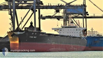
TING MAY
Cargo
Current Trip
| Time Travelled | 18 days |
|---|---|
| Remaining Time | --- |
| Distance Travelled | 4892.69 nm |
| Remaining Distance | --- |
| AVG Speed | 12.6 Knots |
| MAX Speed | 15 Knots |
| AVG Wind | 11.7 knots |
| MAX Wind | 23.4 knots |
| MIN Temp | 14.5°C / 58.1°F |
| MAX Temp | 30.6°C / 87.08°F |
| Draught | 8 m |
| Position Received | 15 h, 12 m ago |
Current Position
| Longitude | -44.23161° |
|---|---|
| Latitude | -2.40362° |
| Status | At anchor |
| Speed | |
| Course | 39° |
| Area | South Atlantic Ocean |
| Station | T-AIS |
| Position Received | 15 h, 12 m ago |
Info
Information
The current position of TING MAY is in South Atlantic Ocean with coordinates -2.40362° / -44.23161° as reported on 2024-05-18 06:23 by AIS to our vessel tracker app. The vessel's current speed is 0 Knots and is heading at the port of ITAQUI. The estimated time of arrival as calculated by vessel tracking app is 2024-05-16 14:00 LT
The vessel TING MAY (IMO: 9853113, MMSI: 636018657) is a Cargo It's sailing under the flag of [LR] Liberia.
In this page you can find informations about the vessels current position, last detected port calls, and current voyage information. If the vessels is not in coverage by AIS you will find the latest position.
The current position of TING MAY is detected by our AIS receivers and we are not responsible for the reliability of the data. The last position was recorded while the vessel was in Coverage by the Ais receivers of our vessel tracking app.
The current draught of TING MAY as reported by AIS is 8 meters
Weather
| Temperature | 27.4°C / 81.32°F |
|---|---|
| Wind Speed | 11 knots |
| Direction | 68° ENE |
| Pressure | 1011.3 hPa |
| Humidity | 81.6 % |
| Cloud Coverage | 20 % |
Featured Company
Last Port Calls
| Port | Arrival | Departure | Time In Port |
|---|---|---|---|
| 2024-04-22 05:01 | 2024-04-30 11:52 | 8 d | |
| 2024-03-26 03:00 | 2024-03-29 03:26 | 3 d |
Most Visited Ports (Last year)
| Port | Arrivals | |
|---|---|---|
| 3 | ||
| 1 | ||
| 1 | ||
| 1 | ||
| 1 | ||
| 1 |
Last Trips
| Origin | Departure | Destination | Arrival | Distance | |
|---|---|---|---|---|---|
| 2024-03-29 00:26 | 2024-04-22 07:01 | 5340.28 nm | |||
| 2024-02-14 21:14 | 2024-03-26 00:00 | 6529.45 nm |
Events
| Time | Event | Details | Position / Dest | Info |
|---|---|---|---|---|
| 2024-05-18 06:29 | Status Changed | Default At anchor |
-2.40361 / -44.23152
BRITQ
|
Speed: Course: 39° |
| 2024-05-18 06:23 | OUT of Coverage |
-2.40362 / -44.23161
South Atlantic Ocean
|
Speed: Course: 112.2° |
|
| 2024-05-18 04:44 | Status Changed | At anchor Default |
-2.40361 / -44.23166
BRITQ
|
Speed: 0.1 kn Course: 44° |
| 2024-05-18 04:44 | IN Coverage |
-2.40366 / -44.23165
South Atlantic Ocean
|
Speed: 0.1 kn Course: 191.4° |
|
| 2024-05-17 17:53 | Status Changed | Default At anchor |
-2.40304 / -44.23213
BRITQ
|
Speed: 0.5 kn Course: 48° |
| 2024-05-17 17:50 | OUT of Coverage |
-2.40333 / -44.23193
South Atlantic Ocean
|
Speed: 0.5 kn Course: 322.1° |
|
| 2024-05-17 17:02 | Status Changed | At anchor Default |
-2.40321 / -44.23193
BRITQ
|
Speed: 0.2 kn Course: 62° |
| 2024-05-17 16:50 | IN Coverage |
-2.40321 / -44.23193
South Atlantic Ocean
|
Speed: Course: 84.8° |
|
| 2024-05-16 17:23 | Status Changed | Default At anchor |
-2.40382 / -44.23156
BRITQ
|
Speed: Course: 37° |
| 2024-05-16 17:20 | OUT of Coverage |
-2.40381 / -44.23158
South Atlantic Ocean
BRITQ
|
Speed: Course: 147.2° |