
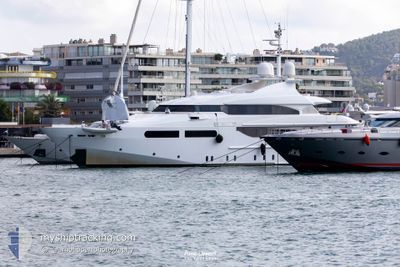
TITIAN PEARL
Pleasure Craft
Current Trip
| Trip Time | 23 h, 42 mins |
|---|---|
| Trip Distance | 31.75 nm |
| AVG Speed | 10.1 Knots |
| MAX Speed | 12.3 Knots |
| Draught | 0 m |
| AVG Wind | 5.8 knots |
| MAX Wind | 14.3 knots |
| MIN Temp | 20.9°C / 69.62°F |
| MAX Temp | 24.7°C / 76.46°F |
| Position Received | 4 m ago |
Current Position
| Longitude | 2.62906° |
|---|---|
| Latitude | 39.56124° |
| Status | Moored |
| Speed | |
| Course | 213° |
| Area | Balearic Sea |
| Station | T-AIS |
| Position Received | 4 m ago |
Info
Information
The current position of TITIAN PEARL is in Balearic Sea with coordinates 39.56124° / 2.62906° as reported on 2024-06-27 21:19 by AIS to our vessel tracker app. The vessel's current speed is 0 Knots and is currently inside the port of PALMA DE MALLORCA.
The vessel TITIAN PEARL (IMO: 9095735, MMSI: 229072000) is a Pleasure Craft It's sailing under the flag of [MT] Malta.
In this page you can find informations about the vessels current position, last detected port calls, and current voyage information. If the vessels is not in coverage by AIS you will find the latest position.
The current position of TITIAN PEARL is detected by our AIS receivers and we are not responsible for the reliability of the data. The last position was recorded while the vessel was in Coverage by the Ais receivers of our vessel tracking app.
Weather
| Temperature | 22.6°C / 72.68°F |
|---|---|
| Wind Speed | 10 knots |
| Direction | 49° NE |
| Pressure | 1012.6 hPa |
| Humidity | 65.4 % |
| Cloud Coverage | 41 % |
Featured Company
Last Port Calls
| Port | Arrival | Departure | Time In Port |
|---|---|---|---|
| 2024-06-20 05:36 | |||
| 2024-06-18 17:34 | 2024-06-19 05:54 | 12 h | |
| 2024-06-16 16:43 | 2024-06-18 08:22 | 1 d | |
| 2024-06-11 16:43 | 2024-06-16 06:15 | 4 d | |
| 2024-06-06 08:21 | 2024-06-11 05:51 | 4 d | |
| 2024-05-30 17:58 | 2024-06-06 06:20 | 6 d | |
| 2024-05-30 12:33 |
Most Visited Ports (Last year)
| Port | Arrivals | |
|---|---|---|
| 3 | ||
| 2 | ||
| 1 |
Last Trips
| Origin | Departure | Destination | Arrival | Distance | |
|---|---|---|---|---|---|
| 2024-06-19 07:54 | 2024-06-20 07:36 | 31.75 nm | |||
| 2024-06-18 10:22 | 2024-06-18 19:34 | 47.34 nm | |||
| 2024-06-16 08:15 | 2024-06-16 18:43 | 12.01 nm | |||
| 2024-06-11 07:51 | 2024-06-11 18:43 | 126.06 nm | |||
| 2024-06-06 08:20 | 2024-06-06 10:21 | 9.08 nm | |||
| 2024-05-30 14:33 | 2024-05-30 19:58 | 35.87 nm |
Events
| Time | Event | Details | Position / Dest | Info |
|---|---|---|---|---|
| 2024-06-20 06:06 | Status Changed | Moored Under way using engine |
39.56121 / 2.62906
[ES] PALMA DE MALLORCA
|
Speed: Course: 270° |
| 2024-06-20 05:45 | STOP Moving |
39.56090 / 2.63002
[ES] PALMA DE MALLORCA
|
Speed: 0.3 kn Course: 330° |
|
| 2024-06-20 05:36 | PORT ARRIVAL |
|
39.55322 / 2.64089
[ES] PALMA DE MALLORCA
|
Speed: 5.8 kn Course: 319.9° |
| 2024-06-20 03:57 | START Moving | 2.88 nm, North West of SANTA PONSA |
39.53269 / 2.40893
PALMA
|
Speed: 7.2 kn Course: 169.9° |
| 2024-06-20 03:53 | Destination Changed | PALMA CAMP DE MAR |
39.53461 / 2.40832
PALMA
|
Speed: 0.2 kn Course: 95° |
| 2024-06-20 03:47 | Status Changed | Under way using engine At anchor |
39.53480 / 2.40827
CAMP DE MAR
|
Speed: Course: 210° |
| 2024-06-20 01:37 | IN Coverage |
39.53492 / 2.40849
Balearic Sea
|
Speed: 0.2 kn Course: 315.7° |
|
| 2024-06-20 00:22 | OUT of Coverage |
39.53491 / 2.40864
Balearic Sea
|
Speed: Course: 230.1° |
|
| 2024-06-19 17:55 | STOP Moving | 2.96 nm, North West of SANTA PONSA |
39.53508 / 2.40871
CAMP DE MAR
|
Speed: 0.2 kn Course: 250° |
| 2024-06-19 17:52 | START Moving | 2.9 nm, North West of SANTA PONSA |
39.53434 / 2.40964
CAMP DE MAR
|
Speed: 4.3 kn Course: 320° |