
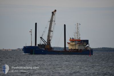
TJALFE R
Motor Hopper
Current Trip
| Time Travelled | 10 h, 35 mins |
|---|---|
| Remaining Time | --- |
| Distance Travelled | 2.43 nm |
| Remaining Distance | --- |
| AVG Speed | 6.6 Knots |
| MAX Speed | 6.6 Knots |
| AVG Wind | 19 knots |
| MAX Wind | 19.9 knots |
| MIN Temp | 14.8°C / 58.64°F |
| MAX Temp | 15.3°C / 59.54°F |
| Draught | 3.5 m |
| Position Received | 6 h, 36 m ago |
Current Position
| Longitude | 13.64452° |
|---|---|
| Latitude | 54.49535° |
| Status | Restricted manoeuverability |
| Speed | 0.8 Knots |
| Course | 75° |
| Area | Baltic Sea |
| Station | T-AIS |
| Position Received | 6 h, 36 m ago |
Info
Information
The current position of TJALFE R is in Baltic Sea with coordinates 54.49535° / 13.64452° as reported on 2024-06-05 11:19 by AIS to our vessel tracker app. The vessel's current speed is 0.8 Knots
The vessel TJALFE R (IMO: 9281889, MMSI: 244641000) is a Motor Hopper that was built in 2002 ( 22 years old ). It's sailing under the flag of [NL] Netherlands.
In this page you can find informations about the vessels current position, last detected port calls, and current voyage information. If the vessels is not in coverage by AIS you will find the latest position.
The current position of TJALFE R is detected by our AIS receivers and we are not responsible for the reliability of the data. The last position was recorded while the vessel was in Coverage by the Ais receivers of our vessel tracking app.
The current draught of TJALFE R as reported by AIS is 3.5 meters
Weather
| Temperature | 15.3°C / 59.54°F |
|---|---|
| Wind Speed | 18 knots |
| Direction | 279° W |
| Pressure | 1009.1 hPa |
| Humidity | 74.8 % |
| Cloud Coverage | 99 % |
Featured Company
Most Visited Ports (Last year)
| Port | Arrivals | |
|---|---|---|
| 84 | ||
| 28 | ||
| 5 | ||
| 3 | ||
| 3 | ||
| 2 |
Last Trips
| Origin | Departure | Destination | Arrival | Distance | |
|---|---|---|---|---|---|
| 2024-05-29 10:49 | 2024-06-05 06:52 | 403.01 nm | |||
| 2024-05-27 20:29 | 2024-05-29 06:07 | 68.22 nm | |||
| 2024-05-25 10:28 | 2024-05-26 13:35 | 193.51 nm | |||
| 2024-04-05 13:12 | 2024-05-21 15:33 | 2335.47 nm | |||
| 2024-03-27 16:20 | 2024-04-05 10:51 | 534.99 nm |
Events
| Time | Event | Details | Position / Dest | Info |
|---|---|---|---|---|
| 2024-06-05 11:19 | OUT of Coverage |
54.49535 / 13.64452
Baltic Sea
|
Speed: 0.8 kn Course: 264.4° |
|
| 2024-06-05 11:19 | IN Coverage |
54.49535 / 13.64452
Baltic Sea
|
Speed: 0.8 kn Course: 264.4° |
|
| 2024-06-05 10:08 | OUT of Coverage |
54.45509 / 13.64990
Baltic Sea
|
Speed: 6.6 kn Course: 340.9° |
|
| 2024-06-05 10:08 | IN Coverage |
54.45509 / 13.64990
Baltic Sea
|
Speed: 6.6 kn Course: 340.9° |
|
| 2024-06-05 07:21 | PORT DEPARTURE |
|
54.45509 / 13.64990
LUBMIN
|
Speed: 0.3 kn Course: 147° |
| 2024-06-05 05:00 | OUT of Coverage |
54.15060 / 13.65233
Baltic Sea
[DE] LUBMIN
|
Speed: 0.3 kn Course: 32.1° |
|
| 2024-06-05 05:00 | STOP Moving |
54.15060 / 13.65233
[DE] LUBMIN
|
Speed: 0.3 kn Course: 147° |
|
| 2024-06-05 04:52 | PORT ARRIVAL |
|
54.15510 / 13.64480
[DE] LUBMIN
|
Speed: 6.5 kn Course: 139.5° |
| 2024-06-05 04:47 | Status Changed | Under way using engine Restricted manoeuverability |
54.16244 / 13.63342
LUBMIN
|
Speed: 6.6 kn Course: 138° |
| 2024-06-05 04:19 | START Moving | 4.1 nm, North of LUBMIN |
54.20884 / 13.62949
LUBMIN
|
Speed: 5.7 kn Course: 188.6° |