
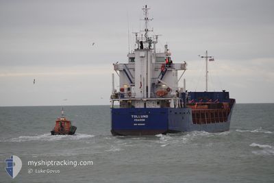
TOLLUND
General Cargo
Current Trip
| Time Travelled | 4 days |
|---|---|
| Remaining Time | 5 h, 34 mins |
| Distance Travelled | 407.20 nm |
| Remaining Distance | 60.71 nm |
| AVG Speed | 8.1 Knots |
| MAX Speed | 11.6 Knots |
| AVG Wind | 24 knots |
| MAX Wind | 27.6 knots |
| MIN Temp | 10.3°C / 50.54°F |
| MAX Temp | 15.9°C / 60.62°F |
| Draught | 5.6 m |
| Position Received | Now |
Current Position
| Longitude | 9.19143° |
|---|---|
| Latitude | 57.48351° |
| Status | Under way using engine |
| Speed | 10.2 Knots |
| Course | 72.2° |
| Area | Skaggerak |
| Station | T-AIS |
| Position Received | Now |
Info
Information
The current position of TOLLUND is in Skaggerak with coordinates 57.48351° / 9.19143° as reported on 2024-06-03 00:30 by AIS to our vessel tracker app. The vessel's current speed is 10.2 Knots and is heading at the port of SKAGEN. The estimated time of arrival as calculated by vessel tracking app is 2024-06-03 06:04 LT
The vessel TOLLUND (IMO: 9088287, MMSI: 261159000) is a General Cargo that was built in 1994 ( 30 years old ). It's sailing under the flag of [PL] Poland.
In this page you can find informations about the vessels current position, last detected port calls, and current voyage information. If the vessels is not in coverage by AIS you will find the latest position.
The current position of TOLLUND is detected by our AIS receivers and we are not responsible for the reliability of the data. The last position was recorded while the vessel was in Coverage by the Ais receivers of our vessel tracking app.
The current draught of TOLLUND as reported by AIS is 5.6 meters
Weather
| Temperature | 13.6°C / 56.48°F |
|---|---|
| Wind Speed | 16 knots |
| Direction | 261° W |
| Pressure | 1009.9 hPa |
| Humidity | 84 % |
| Cloud Coverage | 52 % |
Featured Company
Last Port Calls
| Port | Arrival | Departure | Time In Port |
|---|---|---|---|
| 2024-05-28 04:53 | 2024-05-29 18:29 | 1 d | |
| 2024-05-18 04:12 | 2024-05-21 19:20 | 3 d | |
| 2024-05-16 06:32 | 2024-05-17 10:28 | 1 d | |
| 2024-05-09 04:56 | 2024-05-10 18:21 | 1 d | |
| 2024-05-01 09:08 | 2024-05-04 02:40 | 2 d | |
| 2024-04-29 09:28 | 2024-04-30 14:20 | 1 d | |
| 2024-04-22 02:34 | 2024-04-24 06:52 | 2 d | |
| 2024-04-13 04:26 | 2024-04-15 17:27 | 2 d | |
| 2024-04-10 15:46 | 2024-04-12 10:26 | 1 d | |
| 2024-04-03 08:39 | 2024-04-05 12:26 | 2 d |
Last Trips
| Origin | Departure | Destination | Arrival | Distance | |
|---|---|---|---|---|---|
| 2024-05-21 22:20 | 2024-05-28 05:53 | 1064.92 nm | |||
| 2024-05-17 13:28 | 2024-05-18 07:12 | 186.34 nm | |||
| 2024-05-10 19:21 | 2024-05-16 09:32 | 929.16 nm | |||
| 2024-05-04 05:40 | 2024-05-09 05:56 | 1083.30 nm | |||
| 2024-04-30 17:20 | 2024-05-01 12:08 | 182.39 nm | |||
| 2024-04-24 07:52 | 2024-04-29 12:28 | 918.75 nm | |||
| 2024-04-15 20:27 | 2024-04-22 03:34 | 1080.35 nm | |||
| 2024-04-12 13:26 | 2024-04-13 07:26 | 171.75 nm | |||
| 2024-04-05 13:26 | 2024-04-10 18:46 | 927.01 nm | |||
| 2024-03-29 14:33 | 2024-04-03 09:39 | 1090.11 nm |
Events
| Time | Event | Details | Position / Dest | Info |
|---|---|---|---|---|
| 2024-06-02 21:29 | Detected in Sea | Danish part of the Skaggerak |
57.26970 / 8.35702
Skaggerak
DK SKA
|
Speed: 9.6 kn Course: 69.9° |
| 2024-06-02 20:21 | ETA Changed | 2024/06/03 09:00 2024/06/03 08:00 |
57.19117 / 8.06890
DK SKA
|
Speed: 9.4 kn Course: 48.6° |
| 2024-06-02 16:04 | Change Sea Area | Danish part of the North Sea Norwegian part of the North Sea |
57.13556 / 6.82627
North Sea
DK SKA
|
Speed: 10.1 kn Course: 115.2° |
| 2024-06-02 15:49 | Change Sea Area | Norwegian part of the North Sea Danish part of the North Sea |
57.12933 / 6.78410
North Sea
DK SKA
|
Speed: 7.5 kn Course: 21.3° |
| 2024-06-02 12:05 | Status Changed | Under way using engine Default |
56.76638 / 6.39537
DK SKA
|
Speed: 6.7 kn Course: 25° |
| 2024-06-02 11:58 | Status Changed | Default Under way using engine |
56.75456 / 6.38342
DK SKA
|
Speed: 6.8 kn Course: 28.9° |
| 2024-06-01 22:19 | ETA Changed | 2024/06/03 08:00 2024/06/02 21:00 |
55.96153 / 4.02475
DK SKA
|
Speed: 9.3 kn Course: 94.5° |
| 2024-06-01 21:52 | Change Sea Area | Danish part of the North Sea United Kingdom part of the North Sea |
55.94436 / 3.92399
North Sea
DK SKA
|
Speed: 8.5 kn Course: 85° |
| 2024-06-01 21:52 | Status Changed | Under way using engine Default |
55.94415 / 3.92304
DK SKA
|
Speed: 8.4 kn Course: 76° |
| 2024-06-01 21:52 | IN Coverage |
55.94436 / 3.92399
North Sea
DK SKA
|
Speed: 8.5 kn Course: 85° |