
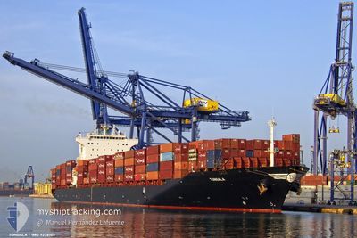
TONGALA
Container Ship
Current Trip
| Time Travelled | 6 days |
|---|---|
| Remaining Time | --- |
| Distance Travelled | 1362.02 nm |
| Remaining Distance | 704.16 nm |
| AVG Speed | 11.4 Knots |
| MAX Speed | 17 Knots |
| AVG Wind | 11.4 knots |
| MAX Wind | 20 knots |
| MIN Temp | 16.8°C / 62.24°F |
| MAX Temp | 32°C / 89.6°F |
| Draught | 11.9 m |
| Position Received | 6 d ago |
Current Position
| Longitude | -77.15194° |
|---|---|
| Latitude | 3.83212° |
| Status | Under way using engine |
| Speed | 14.3 Knots |
| Course | 245.1° |
| Area | North Pacific Ocean |
| Station | T-AIS |
| Position Received | 6 d ago |
Info
Information
The current position of TONGALA is in North Pacific Ocean with coordinates 3.83212° / -77.15194° as reported on 2024-05-22 18:19 by AIS to our vessel tracker app. The vessel's current speed is 14.3 Knots and is heading at the port of GUAYAQUIL. The estimated time of arrival as calculated by vessel tracking app is 2024-05-25 02:00 LT
The vessel TONGALA (IMO: 9278105, MMSI: 636013644) is a Container Ship that was built in 2004 ( 20 years old ). It's sailing under the flag of [LR] Liberia.
In this page you can find informations about the vessels current position, last detected port calls, and current voyage information. If the vessels is not in coverage by AIS you will find the latest position.
The current position of TONGALA is detected by our AIS receivers and we are not responsible for the reliability of the data. The last position was recorded while the vessel was in Coverage by the Ais receivers of our vessel tracking app.
The current draught of TONGALA as reported by AIS is 11.9 meters
Weather
| Temperature | 16.8°C / 62.24°F |
|---|---|
| Wind Speed | 2 knots |
| Direction | 182° S |
| Pressure | 1015.3 hPa |
| Humidity | 88.7 % |
| Cloud Coverage | 100 % |
Featured Company
Last Port Calls
| Port | Arrival | Departure | Time In Port |
|---|---|---|---|
| 2024-05-21 20:52 | 2024-05-22 17:55 | 21 h | |
| 2024-04-24 23:03 | 2024-04-25 12:44 | 13 h | |
| 2024-04-17 11:56 | 2024-04-17 23:25 | 11 h | |
| 2024-04-15 08:26 | 2024-04-15 17:27 | 9 h | |
| 2024-04-11 03:21 | 2024-04-12 00:17 | 20 h | |
| 2024-04-08 07:05 | 2024-04-08 22:19 | 15 h | |
| 2024-03-13 15:46 | 2024-03-14 19:49 | 1 d | |
| 2024-03-09 08:21 | 2024-03-09 18:20 | 9 h | |
| 2024-03-02 14:25 | 2024-03-03 08:49 | 18 h |
Most Visited Ports (Last year)
| Port | Arrivals | |
|---|---|---|
| 5 | ||
| 4 | ||
| 3 | ||
| 3 | ||
| 3 | ||
| 3 |
Last Trips
| Origin | Departure | Destination | Arrival | Distance | |
|---|---|---|---|---|---|
| 2024-04-25 21:44 | 2024-05-21 15:52 | 8747.12 nm | |||
| 2024-04-18 07:25 | 2024-04-25 08:03 | 804.36 nm | |||
| 2024-04-16 01:27 | 2024-04-17 19:56 | 466.58 nm | |||
| 2024-04-12 08:17 | 2024-04-15 16:26 | 481.80 nm | |||
| 2024-04-09 07:19 | 2024-04-11 11:21 | 774.45 nm | |||
| 2024-03-14 16:49 | 2024-04-08 16:05 | 10046.45 nm | |||
| 2024-03-09 13:20 | 2024-03-13 12:46 | 1336.77 nm | |||
| 2024-03-03 03:49 | 2024-03-09 03:21 | 1138.44 nm | |||
| 2024-02-27 04:14 | 2024-03-02 09:25 | 1708.73 nm |
Events
| Time | Event | Details | Position / Dest | Info |
|---|---|---|---|---|
| 2024-05-29 07:31 | STOP Moving | 3.41 nm, North West of CALLAO |
-12.01393 / -77.19471
ECGYE
|
Speed: 0.3 kn Course: 123° |
| 2024-05-28 23:02 | START Moving |
-11.42387 / -78.23081
ECGYE
|
Speed: 3.1 kn Course: 181° |
|
| 2024-05-28 03:20 | STOP Moving |
-11.77060 / -78.25848
ECGYE
|
Speed: 0.2 kn Course: 160° |
|
| 2024-05-25 09:49 | START Moving | 6.45 nm, South of GUAYAQUIL |
-2.28833 / -79.90500
ECGYE
|
Speed: 5 kn Course: 220° |
| 2024-05-24 12:28 | STOP Moving | 6.11 nm, South of GUAYAQUIL |
-2.28333 / -79.90166
ECGYE
|
Speed: Course: -1° |
| 2024-05-24 07:48 | START Moving | 14.18 nm, West of POSORJA |
-2.75940 / -80.47052
ECGYE
|
Speed: 4.8 kn Course: 71° |
| 2024-05-24 07:16 | STOP Moving | 14.61 nm, West of POSORJA |
-2.75667 / -80.47833
ECGYE
|
Speed: Course: -1° |
| 2024-05-22 18:27 | Status Changed | Default Under way using engine |
3.81981 / -77.17877
ECGYE
|
Speed: 14.3 kn Course: 245.1° |
| 2024-05-22 18:19 | OUT of Coverage |
3.83212 / -77.15194
North Pacific Ocean
ECGYE
|
Speed: 14.3 kn Course: 245.1° |
|
| 2024-05-22 18:02 | Draught Changed | 11.9 12.7 |
3.86457 / -77.09354
ECGYE
|
Speed: 11.4 kn Course: 223.5° |