
TRANSITORIO
Cargo
Current Trip
| Time Travelled | --- |
|---|---|
| Remaining Time | --- |
| Distance Travelled | --- |
| Remaining Distance | --- |
| AVG Speed | --- |
| MAX Speed | --- |
| AVG Wind | --- |
| MAX Wind | --- |
| MIN Temp | --- |
| MAX Temp | --- |
| Draught | 0.1 m |
| Position Received | 2 d ago |
Current Position
| Longitude | 9.13941° |
|---|---|
| Latitude | 49.31361° |
| Status | Under way using engine |
| Speed | 4.1 Knots |
| Course | 308.6° |
| Area | North Sea |
| Station | T-AIS |
| Position Received | 2 d ago |
Info
Information
The current position of TRANSITORIO is in North Sea with coordinates 49.31361° / 9.13941° as reported on 2024-06-14 14:59 by AIS to our vessel tracker app. The vessel's current speed is 4.1 Knots
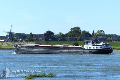
The vessel TRANSITORIO (MMSI: 244670969) is a Cargo It's sailing under the flag of [NL] Netherlands.
In this page you can find informations about the vessels current position, last detected port calls, and current voyage information. If the vessels is not in coverage by AIS you will find the latest position.
The current position of TRANSITORIO is detected by our AIS receivers and we are not responsible for the reliability of the data. The last position was recorded while the vessel was in Coverage by the Ais receivers of our vessel tracking app.
The current draught of TRANSITORIO as reported by AIS is 0.1 meters
Weather
| Temperature | 15.5°C / 59.9°F |
|---|---|
| Wind Speed | 2 knots |
| Direction | 315° NW |
| Pressure | 1012 hPa |
| Humidity | 84.2 % |
| Cloud Coverage | 99 % |
Featured Company
Last Port Calls
| Port | Arrival | Departure | Time In Port |
|---|---|---|---|
| 2024-06-03 18:37 | 2024-06-04 04:22 | 9 h | |
| 2024-06-03 08:27 | 2024-06-03 09:02 | 35 m | |
| 2024-06-01 14:47 | 2024-06-03 03:55 | 1 d | |
| 2024-05-28 16:38 | 2024-06-01 08:31 | 3 d | |
| 2024-05-28 12:56 | 2024-05-28 13:22 | 26 m | |
| 2024-05-27 06:33 | 2024-05-28 11:05 | 1 d | |
| 2024-05-27 04:29 | 2024-05-27 05:03 | 34 m | |
| 2024-05-22 18:20 | 2024-05-23 04:01 | 9 h | |
| 2024-05-21 07:47 | 2024-05-22 08:04 | 1 d | |
| 2024-05-10 06:36 | 2024-05-21 03:47 | 10 d |
Last Trips
| Origin | Departure | Destination | Arrival | Distance | |
|---|---|---|---|---|---|
| 2024-06-03 11:02 | 2024-06-03 20:37 | 36.49 nm | |||
| 2024-06-03 05:55 | 2024-06-03 10:27 | 23.56 nm | |||
| 2024-06-01 10:31 | 2024-06-01 16:47 | 40.67 nm | |||
| 2024-05-28 15:22 | 2024-05-28 18:38 | 8.26 nm | |||
| 2024-05-28 13:05 | 2024-05-28 14:56 | 6.68 nm | |||
| 2024-05-27 07:03 | 2024-05-27 08:33 | 6.94 nm | |||
| 2024-05-23 06:01 | 2024-05-27 06:29 | 94.43 nm | |||
| 2024-05-22 10:04 | 2024-05-22 20:20 | 51.33 nm | |||
| 2024-05-21 05:47 | 2024-05-21 09:47 | 27.03 nm | |||
| 2024-05-10 08:17 | 2024-05-10 08:36 | 2.26 nm |
Events
| Time | Event | Details | Position / Dest | Info |
|---|---|---|---|---|
| 2024-06-14 14:59 | OUT of Coverage |
49.31361 / 9.13941
North Sea
|
Speed: 4.1 kn Course: 308.6° |
|
| 2024-06-14 13:33 | START Moving | 1.61 nm, South East of BAD WIMPFEN |
49.21897 / 9.20636
HEILBRONN
|
Speed: 6.5 kn Course: 321.2° |
| 2024-06-14 13:19 | STOP Moving | 1.75 nm, South East of BAD WIMPFEN |
49.21692 / 9.20876
HEILBRONN
|
Speed: 0.1 kn Course: 511° |
| 2024-06-14 12:56 | START Moving | 2.2 nm, North of HEILBRONN |
49.18290 / 9.21482
HEILBRONN
|
Speed: 5 kn Course: 36.6° |
| 2024-06-14 12:55 | Status Changed | Under way using engine Moored |
49.18145 / 9.21437
HEILBRONN
|
Speed: Course: 511° |
| 2024-06-14 12:24 | IN Coverage |
49.18111 / 9.21425
North Sea
|
Speed: Course: 0° |
|
| 2024-06-14 05:59 | OUT of Coverage |
49.18111 / 9.21428
North Sea
|
Speed: 0.1 kn Course: 47.3° |
|
| 2024-06-14 05:49 | Status Changed | Moored Under way using engine |
49.18089 / 9.21376
HEILBRONN
|
Speed: Course: 511° |
| 2024-06-14 04:41 | STOP Moving | 2.09 nm, North of HEILBRONN |
49.18095 / 9.21420
HEILBRONN
|
Speed: Course: 511° |
| 2024-06-14 04:39 | IN Coverage |
49.18088 / 9.21422
North Sea
|
Speed: 2.5 kn Course: 342.1° |