
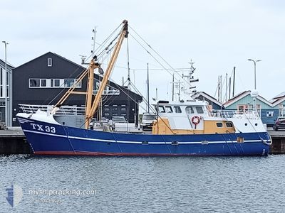
TX33 NOVA SPES
Fishing Vessel
Current Trip
TEXEL
| Time Travelled | 2 days |
|---|---|
| Remaining Time | --- |
| Distance Travelled | 161.80 nm |
| Remaining Distance | --- |
| AVG Speed | 3.7 Knots |
| MAX Speed | 10 Knots |
| AVG Wind | 13 knots |
| MAX Wind | 22.6 knots |
| MIN Temp | 13.2°C / 55.76°F |
| MAX Temp | 15.5°C / 59.9°F |
| Draught | 2.2 m |
| Position Received | Now |
Current Position
| Longitude | 4.83243° |
|---|---|
| Latitude | 53.23116° |
| Status | Engaged in Fishing |
| Speed | 2.4 Knots |
| Course | 238° |
| Area | North Sea |
| Station | T-AIS |
| Position Received | Now |
Info
Information
The current position of TX33 NOVA SPES is in North Sea with coordinates 53.23116° / 4.83243° as reported on 2024-05-23 05:48 by AIS to our vessel tracker app. The vessel's current speed is 2.4 Knots
The vessel TX33 NOVA SPES (IMO: 8985153, MMSI: 246570000) is a Fishing Vessel that was built in 1984 ( 40 years old ). It's sailing under the flag of [NL] Netherlands.
In this page you can find informations about the vessels current position, last detected port calls, and current voyage information. If the vessels is not in coverage by AIS you will find the latest position.
The current position of TX33 NOVA SPES is detected by our AIS receivers and we are not responsible for the reliability of the data. The last position was recorded while the vessel was in Coverage by the Ais receivers of our vessel tracking app.
The current draught of TX33 NOVA SPES as reported by AIS is 2.2 meters
Weather
| Temperature | 13.2°C / 55.76°F |
|---|---|
| Wind Speed | 16 knots |
| Direction | 208° SSW |
| Pressure | 1010.6 hPa |
| Humidity | 94.5 % |
| Cloud Coverage | 24 % |
Featured Company
Last Port Calls
| Port | Arrival | Departure | Time In Port |
|---|---|---|---|
| 2024-05-16 15:54 | 2024-05-20 17:32 | 4 d | |
| 2024-05-16 10:27 | 2024-05-16 15:09 | 4 h | |
| 2024-05-10 05:55 | 2024-05-12 21:35 | 2 d | |
| 2024-05-08 14:34 | 2024-05-08 15:30 | 56 m | |
| 2024-05-03 06:38 | 2024-05-05 21:32 | 2 d | |
| 2024-05-01 10:24 | 2024-05-01 11:30 | 1 h | |
| 2024-04-26 06:12 | 2024-04-28 21:34 | 2 d | |
| 2024-04-24 00:57 | 2024-04-24 17:59 | 17 h | |
| 2024-04-19 03:13 | 2024-04-21 21:31 | 2 d | |
| 2024-04-12 07:13 | 2024-04-16 17:41 | 4 d |
Most Visited Ports (Last year)
| Port | Arrivals | |
|---|---|---|
| 34 | ||
| 16 | ||
| 8 | ||
| 4 | ||
| 4 | ||
| 1 |
Last Trips
| Origin | Departure | Destination | Arrival | Distance | |
|---|---|---|---|---|---|
| 2024-05-16 17:09 | 2024-05-16 17:54 | 5.24 nm | |||
| 2024-05-12 23:35 | 2024-05-16 12:27 | 223.44 nm | |||
| 2024-05-08 17:30 | 2024-05-10 07:55 | 117.33 nm | |||
| 2024-05-05 23:32 | 2024-05-08 16:34 | 207.72 nm | |||
| 2024-05-01 13:30 | 2024-05-03 08:38 | 138.73 nm | |||
| 2024-04-28 23:34 | 2024-05-01 12:24 | 192.05 nm | |||
| 2024-04-24 19:59 | 2024-04-26 08:12 | 120.12 nm | |||
| 2024-04-21 23:31 | 2024-04-24 02:57 | 163.72 nm | |||
| 2024-04-16 19:41 | 2024-04-19 05:13 | 176.06 nm | |||
| 2024-04-10 08:46 | 2024-04-12 09:13 | 143.71 nm |
Events
| Time | Event | Details | Position / Dest | Info |
|---|---|---|---|---|
| 2024-05-22 21:42 | IN Coverage |
53.14834 / 4.77371
North Sea
|
Speed: 3.4 kn Course: 203.9° |
|
| 2024-05-22 19:41 | OUT of Coverage |
53.23439 / 4.84478
North Sea
|
Speed: 2.9 kn Course: 244° |
|
| 2024-05-22 17:19 | START Moving | 6.4 nm, West of VLIELAND |
53.26436 / 4.91196
TEXEL
|
Speed: 3.1 kn Course: 141° |
| 2024-05-22 17:00 | STOP Moving | 5.89 nm, West of VLIELAND |
53.27096 / 4.92359
TEXEL
|
Speed: 0.2 kn Course: 228° |
| 2024-05-22 16:26 | IN Coverage |
53.28293 / 4.94395
North Sea
|
Speed: 2.6 kn Course: 159.4° |
|
| 2024-05-22 14:59 | OUT of Coverage |
53.23166 / 4.83040
North Sea
|
Speed: 3.9 kn Course: 66.3° |
|
| 2024-05-22 14:35 | IN Coverage |
53.22910 / 4.82230
North Sea
|
Speed: 3.4 kn Course: 90.2° |
|
| 2024-05-22 12:44 | OUT of Coverage |
53.22729 / 4.82139
North Sea
|
Speed: 2.9 kn Course: 298.2° |
|
| 2024-05-22 12:44 | IN Coverage |
53.22707 / 4.82191
North Sea
|
Speed: 3.1 kn Course: 321.5° |
|
| 2024-05-22 10:56 | OUT of Coverage |
53.23101 / 4.82672
North Sea
|
Speed: 2.9 kn Course: 257.7° |