
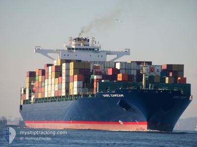
UASC ZAMZAM
Cargo
Current Trip
| Time Travelled | 2 days |
|---|---|
| Remaining Time | --- |
| Distance Travelled | 1340.79 nm |
| Remaining Distance | --- |
| AVG Speed | 18.1 Knots |
| MAX Speed | 20 Knots |
| AVG Wind | 14.6 knots |
| MAX Wind | 24.9 knots |
| MIN Temp | 18.9°C / 66.02°F |
| MAX Temp | 22.4°C / 72.32°F |
| Draught | 15.1 m |
| Position Received | 1 d ago |
Current Position
| Longitude | -13.59062° |
|---|---|
| Latitude | 27.85264° |
| Status | Under way using engine |
| Speed | 19.4 Knots |
| Course | 222.9° |
| Area | North Atlantic Ocean |
| Station | T-AIS |
| Position Received | 1 d ago |
Info
Information
The current position of UASC ZAMZAM is in North Atlantic Ocean with coordinates 27.85264° / -13.59062° as reported on 2024-06-27 19:36 by AIS to our vessel tracker app. The vessel's current speed is 19.4 Knots and is heading at the port of SALALAH. The estimated time of arrival as calculated by vessel tracking app is 2024-07-17 21:00 LT
The vessel UASC ZAMZAM (IMO: 9699127, MMSI: 636093197) is a Cargo It's sailing under the flag of [LR] Liberia.
In this page you can find informations about the vessels current position, last detected port calls, and current voyage information. If the vessels is not in coverage by AIS you will find the latest position.
The current position of UASC ZAMZAM is detected by our AIS receivers and we are not responsible for the reliability of the data. The last position was recorded while the vessel was in Coverage by the Ais receivers of our vessel tracking app.
The current draught of UASC ZAMZAM as reported by AIS is 15.1 meters
Weather
| Temperature | 22.6°C / 72.68°F |
|---|---|
| Wind Speed | 13 knots |
| Direction | 353° N |
| Pressure | 1011.5 hPa |
| Humidity | 81.3 % |
| Cloud Coverage | 8 % |
Featured Company
Last Port Calls
| Port | Arrival | Departure | Time In Port |
|---|---|---|---|
| 2024-06-25 21:48 | 2024-06-26 09:14 | 11 h | |
| 2024-06-17 04:48 | 2024-06-21 02:15 | 3 d | |
| 2024-06-15 03:39 | 2024-06-16 04:47 | 1 d | |
| 2024-06-12 16:54 | 2024-06-14 01:03 | 1 d | |
| 2024-06-08 00:49 | 2024-06-08 15:59 | 15 h | |
| 2024-05-13 08:48 | 2024-05-14 10:32 | 1 d | |
| 2024-05-11 02:28 | 2024-05-12 02:40 | 1 d | |
| 2024-05-07 19:01 | 2024-05-08 23:28 | 1 d | |
| 2024-04-13 16:48 | 2024-04-14 05:51 | 13 h | |
| 2024-04-11 09:37 | 2024-04-12 04:52 | 19 h |
Most Visited Ports (Last year)
| Port | Arrivals | |
|---|---|---|
| 8 | ||
| 6 | ||
| 4 | ||
| 4 | ||
| 3 | ||
| 3 |
Last Trips
| Origin | Departure | Destination | Arrival | Distance | |
|---|---|---|---|---|---|
| 2024-06-21 03:15 | 2024-06-25 22:48 | 1391.75 nm | |||
| 2024-06-16 06:47 | 2024-06-17 05:48 | 380.72 nm | |||
| 2024-06-14 03:03 | 2024-06-15 05:39 | 287.35 nm | |||
| 2024-06-08 17:59 | 2024-06-12 18:54 | 1423.13 nm | |||
| 2024-05-14 16:02 | 2024-06-08 02:49 | 9881.06 nm | |||
| 2024-05-12 08:10 | 2024-05-13 14:18 | 445.78 nm | |||
| 2024-05-09 03:28 | 2024-05-11 07:58 | 977.35 nm | |||
| 2024-04-14 07:51 | 2024-05-07 23:01 | 10612.96 nm | |||
| 2024-04-12 06:52 | 2024-04-13 18:48 | 270.49 nm | |||
| 2024-04-08 18:04 | 2024-04-11 11:37 | 209.39 nm |
Events
| Time | Event | Details | Position / Dest | Info |
|---|---|---|---|---|
| 2024-06-27 19:44 | Status Changed | Default Under way using engine |
27.81944 / -13.62406
OMSLL
|
Speed: 19.4 kn Course: 222.9° |
| 2024-06-27 19:36 | OUT of Coverage |
27.85264 / -13.59062
North Atlantic Ocean
OMSLL
|
Speed: 19.4 kn Course: 222.9° |
|
| 2024-06-27 19:32 | Status Changed | Under way using engine Default |
27.86791 / -13.57410
OMSLL
|
Speed: 19.6 kn Course: 226° |
| 2024-06-27 18:46 | Status Changed | Default Under way using engine |
28.05049 / -13.37283
OMSLL
|
Speed: 19.4 kn Course: 217.2° |
| 2024-06-27 18:34 | Status Changed | Under way using engine Default |
28.09882 / -13.32950
OMSLL
|
Speed: 19.3 kn Course: 214° |
| 2024-06-27 18:30 | Status Changed | Default Under way using engine |
28.11815 / -13.31404
OMSLL
|
Speed: 19.3 kn Course: 216.1° |
| 2024-06-27 18:24 | Status Changed | Under way using engine Default |
28.14491 / -13.29252
OMSLL
|
Speed: 19.6 kn Course: 216° |
| 2024-06-27 17:37 | Status Changed | Default Under way using engine |
28.35285 / -13.12936
OMSLL
|
Speed: 18.8 kn Course: 216.1° |
| 2024-06-27 17:31 | Change Sea Area | Moroccan part of the North Atlantic Ocean Spanish (Canary Islands) part of the North Atlantic Ocean |
28.37850 / -13.10926
North Atlantic Ocean
OMSLL
|
Speed: 18.8 kn Course: 216.1° |
| 2024-06-27 17:31 | Status Changed | Under way using engine Default |
28.37850 / -13.10926
OMSLL
|
Speed: 19 kn Course: 217° |