
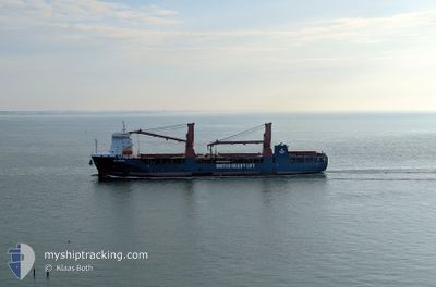
UHL FINESSE
Cargo
Current Trip
| Time Travelled | 7 days |
|---|---|
| Remaining Time | --- |
| Distance Travelled | 1974.27 nm |
| Remaining Distance | --- |
| AVG Speed | 13.5 Knots |
| MAX Speed | 16.2 Knots |
| AVG Wind | 13.6 knots |
| MAX Wind | 26.3 knots |
| MIN Temp | 25.7°C / 78.26°F |
| MAX Temp | 30°C / 86°F |
| Draught | 7.6 m |
| Position Received | 2 d ago |
Current Position
| Longitude | 76.63806° |
|---|---|
| Latitude | 8.27276° |
| Status | Under way using engine |
| Speed | 12.4 Knots |
| Course | 303.7° |
| Area | Laccadive Sea |
| Station | T-AIS |
| Position Received | 2 d ago |
Info
Information
The current position of UHL FINESSE is in Laccadive Sea with coordinates 8.27276° / 76.63806° as reported on 2024-06-22 17:14 by AIS to our vessel tracker app. The vessel's current speed is 12.4 Knots and is heading at the port of KHALIFA. The estimated time of arrival as calculated by vessel tracking app is 2024-06-28 02:00 LT
The vessel UHL FINESSE (IMO: 9892511, MMSI: 255806357) is a Cargo It's sailing under the flag of [PT] Portugal.
In this page you can find informations about the vessels current position, last detected port calls, and current voyage information. If the vessels is not in coverage by AIS you will find the latest position.
The current position of UHL FINESSE is detected by our AIS receivers and we are not responsible for the reliability of the data. The last position was recorded while the vessel was in Coverage by the Ais receivers of our vessel tracking app.
The current draught of UHL FINESSE as reported by AIS is 7.6 meters
Weather
| Temperature | 29.2°C / 84.56°F |
|---|---|
| Wind Speed | 9 knots |
| Direction | 336° NNW |
| Pressure | 999.9 hPa |
| Humidity | 80.9 % |
| Cloud Coverage | 100 % |
Featured Company
Last Port Calls
| Port | Arrival | Departure | Time In Port |
|---|---|---|---|
| 2024-06-17 02:25 | 2024-06-17 16:41 | 14 h | |
| 2024-06-15 13:10 | 2024-06-16 10:04 | 20 h | |
| 2024-06-14 12:15 | 2024-06-14 16:35 | 4 h | |
| 2024-05-22 14:36 | 2024-05-24 21:57 | 2 d | |
| 2024-05-19 06:10 | 2024-05-21 08:17 | 2 d | |
| 2024-05-17 01:04 | 2024-05-18 21:09 | 1 d | |
| 2024-05-04 00:44 | 2024-05-09 05:08 | 5 d |
Most Visited Ports (Last year)
| Port | Arrivals | |
|---|---|---|
| 3 | ||
| 3 | ||
| 2 | ||
| 2 | ||
| 2 | ||
| 2 |
Last Trips
| Origin | Departure | Destination | Arrival | Distance | |
|---|---|---|---|---|---|
| 2024-06-16 18:04 | 2024-06-17 10:25 | 206.04 nm | |||
| 2024-06-14 23:35 | 2024-06-15 21:10 | 20.12 nm | |||
| 2024-05-25 06:57 | 2024-06-14 19:15 | 3063.28 nm | |||
| 2024-05-21 17:17 | 2024-05-22 23:36 | 440.19 nm | |||
| 2024-05-19 06:09 | 2024-05-19 15:10 | 122.65 nm | |||
| 2024-05-09 12:08 | 2024-05-17 10:04 | 2531.46 nm | |||
| 2024-03-30 16:32 | 2024-05-04 07:44 | 1951.91 nm |
Events
| Time | Event | Details | Position / Dest | Info |
|---|---|---|---|---|
| 2024-06-22 17:27 | Status Changed | Default Under way using engine |
8.29884 / 76.59926
AEKHL
|
Speed: 12.4 kn Course: 303.7° |
| 2024-06-22 17:14 | OUT of Coverage |
8.27276 / 76.63806
Laccadive Sea
AEKHL
|
Speed: 12.4 kn Course: 303.7° |
|
| 2024-06-22 12:10 | Draught Changed | 7.6 7.8 |
7.66940 / 77.51504
AEKHL
|
Speed: 11.8 kn Course: 307.4° |
| 2024-06-22 12:10 | Destination Changed | AEKHL MYPKG |
7.66940 / 77.51504
AEKHL
|
Speed: 11.8 kn Course: 307.4° |
| 2024-06-22 12:10 | ETA Changed | 2024/06/28 02:00 2024/06/17 01:00 |
7.66940 / 77.51504
AEKHL
|
Speed: 11.8 kn Course: 307.4° |
| 2024-06-22 11:57 | Detected in Sea | Indian part of the Laccadive Sea |
7.64883 / 77.54796
Laccadive Sea
|
Speed: 11.7 kn Course: 301.5° |
| 2024-06-22 11:57 | Status Changed | Under way using engine Default |
7.64883 / 77.54796
MYPKG
|
Speed: 11.8 kn Course: 303° |
| 2024-06-22 11:57 | IN Coverage |
7.64883 / 77.54796
Laccadive Sea
|
Speed: 11.7 kn Course: 301.5° |
|
| 2024-06-17 16:41 | PORT DEPARTURE |
|
2.90052 / 101.26406
MYPKG
|
Speed: 12.3 kn Course: 220° |
| 2024-06-17 16:21 | START Moving |
2.94956 / 101.29938
[MY] PORT KLANG
|
Speed: 5.6 kn Course: 215° |