
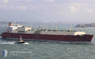
UMM SLAL
Lng Tanker
Current Trip
| Time Travelled | 11 days |
|---|---|
| Remaining Time | --- |
| Distance Travelled | 4024.15 nm |
| Remaining Distance | --- |
| AVG Speed | 15.9 Knots |
| MAX Speed | 18 Knots |
| AVG Wind | 13.6 knots |
| MAX Wind | 26 knots |
| MIN Temp | 26.1°C / 78.98°F |
| MAX Temp | 33.2°C / 91.76°F |
| Draught | 12 m |
| Position Received | 17 h, 49 m ago |
Current Position
| Longitude | 104.33440° |
|---|---|
| Latitude | 1.29080° |
| Status | Under way using engine |
| Speed | 16.5 Knots |
| Course | 50.2° |
| Area | Singapore Strait |
| Station | T-AIS |
| Position Received | 17 h, 49 m ago |
Info
Information
The current position of UMM SLAL is in Singapore Strait with coordinates 1.29080° / 104.33440° as reported on 2024-06-01 14:11 by AIS to our vessel tracker app. The vessel's current speed is 16.5 Knots and is heading at the port of TONGYEONG. The estimated time of arrival as calculated by vessel tracking app is 2024-06-13 00:00 LT
The vessel UMM SLAL (IMO: 9372731, MMSI: 538003300) is a Lng Tanker that was built in 2008 ( 16 years old ). It's sailing under the flag of [MH] Marshall Is.
In this page you can find informations about the vessels current position, last detected port calls, and current voyage information. If the vessels is not in coverage by AIS you will find the latest position.
The current position of UMM SLAL is detected by our AIS receivers and we are not responsible for the reliability of the data. The last position was recorded while the vessel was in Coverage by the Ais receivers of our vessel tracking app.
The current draught of UMM SLAL as reported by AIS is 12 meters
Weather
| Temperature | 28.7°C / 83.66°F |
|---|---|
| Wind Speed | 9 knots |
| Direction | 220° SW |
| Pressure | 1009.1 hPa |
| Humidity | 76.1 % |
| Cloud Coverage | 100 % |
Featured Company
Last Port Calls
| Port | Arrival | Departure | Time In Port |
|---|---|---|---|
| 2024-05-20 06:23 | 2024-05-21 12:34 | 1 d | |
| 2024-04-10 18:28 | 2024-04-11 22:54 | 1 d |
Most Visited Ports (Last year)
| Port | Arrivals | |
|---|---|---|
| 8 | ||
| 4 | ||
| 2 | ||
| 1 |
Last Trips
| Origin | Departure | Destination | Arrival | Distance | |
|---|---|---|---|---|---|
| 2024-04-12 01:54 | 2024-05-20 09:23 | 13234.41 nm | |||
| 2024-01-12 21:07 | 2024-04-10 21:28 | 9657.26 nm |
Events
| Time | Event | Details | Position / Dest | Info |
|---|---|---|---|---|
| 2024-06-01 14:14 | Status Changed | Default Under way using engine |
1.30001 / 104.34534
KR TYG
|
Speed: 16.5 kn Course: 50.2° |
| 2024-06-01 14:11 | OUT of Coverage |
1.29080 / 104.33440
Singapore Strait
KR TYG
|
Speed: 16.5 kn Course: 50.2° |
|
| 2024-06-01 14:10 | Status Changed | Under way using engine Default |
1.28849 / 104.33159
KR TYG
|
Speed: 16.7 kn Course: 86° |
| 2024-06-01 14:02 | Status Changed | Default Under way using engine |
1.28143 / 104.29641
KR TYG
|
Speed: 16.5 kn Course: 83.5° |
| 2024-06-01 13:56 | Status Changed | Under way using engine Default |
1.28051 / 104.26947
KR TYG
|
Speed: 16.8 kn Course: 85° |
| 2024-06-01 13:50 | Status Changed | Default Under way using engine |
1.27788 / 104.24150
KR TYG
|
Speed: 17.1 kn Course: 84.5° |
| 2024-06-01 13:25 | Change Sea Area | Malaysian part of the Singapore Strait Indonesian part of the Singapore Strait |
1.26544 / 104.12348
Singapore Strait
KR TYG
|
Speed: 16.8 kn Course: 82.4° |
| 2024-06-01 11:59 | Change Sea Area | Indonesian part of the Singapore Strait Singaporean part of the Singapore Strait |
1.17253 / 103.80953
Singapore Strait
KR TYG
|
Speed: 13.2 kn Course: 68.1° |
| 2024-06-01 11:52 | Change Sea Area | Singaporean part of the Singapore Strait Indonesian part of the Singapore Strait |
1.16123 / 103.78945
Singapore Strait
KR TYG
|
Speed: 13.2 kn Course: 54.6° |
| 2024-06-01 11:28 | Destination Changed | KR TYG TONGYEONG, SOUTH KOR |
1.09939 / 103.72834
KR TYG
|
Speed: 13.4 kn Course: 48.3° |