
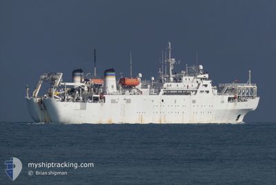
US GOVERNMENT VESSEL
Repair Ship
Current Trip
-
| Trip Time | 19 days |
|---|---|
| Trip Distance | 4176.59 nm |
| AVG Speed | 9.4 Knots |
| MAX Speed | 14.7 Knots |
| Draught | 0 m |
| AVG Wind | 13.5 knots |
| MAX Wind | 32.8 knots |
| MIN Temp | 10.8°C / 51.44°F |
| MAX Temp | 29.1°C / 84.38°F |
| Position Received | 1 h, 35 m ago |
Current Position
| Longitude | -79.95802° |
|---|---|
| Latitude | 32.85942° |
| Status | Moored |
| Speed | |
| Course | 103° |
| Area | North Atlantic Ocean |
| Station | T-AIS |
| Position Received | 1 h, 35 m ago |
Info
Information
The current position of US GOVERNMENT VESSEL is in North Atlantic Ocean with coordinates 32.85942° / -79.95802° as reported on 2024-05-17 02:32 by AIS to our vessel tracker app. The vessel's current speed is 0 Knots and is currently inside the port of CHARLESTON.
The vessel US GOVERNMENT VESSEL (IMO: 7932408, MMSI: 367212000) is a Repair Ship that was built in 1984 ( 40 years old ). It's sailing under the flag of [US] USA.
In this page you can find informations about the vessels current position, last detected port calls, and current voyage information. If the vessels is not in coverage by AIS you will find the latest position.
The current position of US GOVERNMENT VESSEL is detected by our AIS receivers and we are not responsible for the reliability of the data. The last position was recorded while the vessel was in Coverage by the Ais receivers of our vessel tracking app.
Weather
| Temperature | 22.2°C / 71.96°F |
|---|---|
| Wind Speed | 3 knots |
| Direction | 136° SE |
| Pressure | 1010.5 hPa |
| Humidity | 77.1 % |
| Cloud Coverage | 3 % |
Featured Company
Last Port Calls
Most Visited Ports (Last year)
| Port | Arrivals | |
|---|---|---|
| 3 | ||
| 1 | ||
| 1 | ||
| 1 | ||
| 1 | ||
| 1 |
Last Trips
| Origin | Departure | Destination | Arrival | Distance |
|---|
Events
| Time | Event | Details | Position / Dest | Info |
|---|---|---|---|---|
| 2024-05-17 02:32 | OUT of Coverage |
32.85942 / -79.95802
North Atlantic Ocean
[US] CHARLESTON
|
Speed: Course: 124.7° |
|
| 2024-05-17 01:56 | IN Coverage |
32.85941 / -79.95801
North Atlantic Ocean
[US] CHARLESTON
|
Speed: Course: 124.7° |
|
| 2024-05-17 00:26 | OUT of Coverage |
32.85941 / -79.95802
North Atlantic Ocean
[US] CHARLESTON
|
Speed: Course: 165° |
|
| 2024-05-16 19:55 | Destination Changed | - - OLE |
32.85939 / -79.95803
[US] CHARLESTON
|
Speed: Course: 103° |
| 2024-05-16 19:25 | Destination Changed | - OLE - |
32.85940 / -79.95806
[US] CHARLESTON
|
Speed: 0.1 kn Course: 103° |
| 2024-05-16 19:25 | ETA Changed | 2025/01/01 00:00 |
32.85940 / -79.95806
[US] CHARLESTON
|
Speed: 0.1 kn Course: 103° |
| 2024-05-16 08:23 | IN Coverage |
32.85944 / -79.95808
North Atlantic Ocean
[US] CHARLESTON
|
Speed: Course: 135° |
|
| 2024-05-16 05:05 | OUT of Coverage |
32.85945 / -79.95809
North Atlantic Ocean
[US] CHARLESTON
|
Speed: Course: 135° |
|
| 2024-05-15 20:53 | IN Coverage |
32.85941 / -79.95807
North Atlantic Ocean
[US] CHARLESTON
|
Speed: Course: 135° |
|
| 2024-05-15 14:08 | OUT of Coverage |
32.86242 / -79.96702
North Atlantic Ocean
[US] CHARLESTON
|
Speed: Course: 348.2° |