
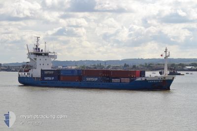
VANQUISH
Container Ship
Current Trip
| Time Travelled | 6 h, 44 mins |
|---|---|
| Remaining Time | 11 h, 8 mins |
| Distance Travelled | 77.87 nm |
| Remaining Distance | 133.95 nm |
| AVG Speed | 12 Knots |
| MAX Speed | 14.1 Knots |
| AVG Wind | 7.1 knots |
| MAX Wind | 11 knots |
| MIN Temp | 10.4°C / 50.72°F |
| MAX Temp | 13.9°C / 57.02°F |
| Draught | 4.1 m |
| Position Received | Now |
Current Position
| Longitude | 1.42279° |
|---|---|
| Latitude | 52.94836° |
| Status | Under way using engine |
| Speed | 11.5 Knots |
| Course | 119.7° |
| Area | North Sea |
| Station | T-AIS |
| Position Received | Now |
Info
Information
The current position of VANQUISH is in North Sea with coordinates 52.94836° / 1.42279° as reported on 2024-05-28 00:27 by AIS to our vessel tracker app. The vessel's current speed is 11.5 Knots and is heading at the port of AMSTERDAM. The estimated time of arrival as calculated by vessel tracking app is 2024-05-28 11:35 LT
The vessel VANQUISH (IMO: 9116199, MMSI: 246141000) is a Container Ship that was built in 1995 ( 29 years old ). It's sailing under the flag of [NL] Netherlands.
In this page you can find informations about the vessels current position, last detected port calls, and current voyage information. If the vessels is not in coverage by AIS you will find the latest position.
The current position of VANQUISH is detected by our AIS receivers and we are not responsible for the reliability of the data. The last position was recorded while the vessel was in Coverage by the Ais receivers of our vessel tracking app.
The current draught of VANQUISH as reported by AIS is 4.1 meters
Weather
| Temperature | 10.9°C / 51.62°F |
|---|---|
| Wind Speed | 11 knots |
| Direction | 233° SW |
| Pressure | 1014.8 hPa |
| Humidity | 86.3 % |
| Cloud Coverage | 46 % |
Featured Company
Last Port Calls
| Port | Arrival | Departure | Time In Port |
|---|---|---|---|
| 2024-05-27 05:18 | 2024-05-27 17:43 | 12 h | |
| 2024-05-25 08:36 | 2024-05-26 12:29 | 1 d | |
| 2024-05-24 05:56 | 2024-05-24 14:39 | 8 h | |
| 2024-05-21 12:47 | 2024-05-23 11:10 | 1 d | |
| 2024-05-20 04:22 | 2024-05-20 17:34 | 13 h | |
| 2024-05-18 17:43 | 2024-05-19 12:56 | 19 h | |
| 2024-05-17 15:31 | 2024-05-17 23:42 | 8 h | |
| 2024-05-16 16:40 | 2024-05-16 20:30 | 3 h | |
| 2024-05-15 15:45 | 2024-05-16 00:56 | 9 h | |
| 2024-05-14 13:39 | 2024-05-14 20:49 | 7 h |
Last Trips
| Origin | Departure | Destination | Arrival | Distance | |
|---|---|---|---|---|---|
| 2024-05-26 14:29 | 2024-05-27 06:18 | 202.84 nm | |||
| 2024-05-24 15:39 | 2024-05-25 10:36 | 186.20 nm | |||
| 2024-05-23 13:10 | 2024-05-24 06:56 | 190.11 nm | |||
| 2024-05-20 18:34 | 2024-05-21 14:47 | 209.02 nm | |||
| 2024-05-19 14:56 | 2024-05-20 05:22 | 200.29 nm | |||
| 2024-05-18 00:42 | 2024-05-18 19:43 | 187.87 nm | |||
| 2024-05-16 22:30 | 2024-05-17 16:31 | 191.14 nm | |||
| 2024-05-16 01:56 | 2024-05-16 18:40 | 185.21 nm | |||
| 2024-05-14 22:49 | 2024-05-15 16:45 | 190.20 nm | |||
| 2024-05-13 19:10 | 2024-05-14 15:39 | 209.17 nm |
Events
| Time | Event | Details | Position / Dest | Info |
|---|---|---|---|---|
| 2024-05-27 23:12 | Status Changed | Under way using engine Default |
53.04823 / 1.04916
NLAMS
|
Speed: 11.7 kn Course: 133° |
| 2024-05-27 23:08 | IN Coverage |
53.04527 / 1.05655
North Sea
NLAMS
|
Speed: 11.9 kn Course: 120.8° |
|
| 2024-05-27 19:25 | Status Changed | Default Under way using engine |
53.54230 / .15196
NLAMS
|
Speed: 13.5 kn Course: 121.1° |
| 2024-05-27 19:20 | OUT of Coverage |
53.55042 / .12524
North Sea
NLAMS
|
Speed: 13.5 kn Course: 121.1° |
|
| 2024-05-27 18:45 | Draught Changed | 4.1 5.8 |
53.60254 / -.06210
NLAMS
|
Speed: 12.1 kn Course: 118.3° |
| 2024-05-27 18:45 | Destination Changed | NLAMS GBHUL |
53.60254 / -.06210
NLAMS
|
Speed: 12.1 kn Course: 118.3° |
| 2024-05-27 18:45 | ETA Changed | 2024/05/28 13:00 2024/05/27 05:00 |
53.60254 / -.06210
NLAMS
|
Speed: 12.1 kn Course: 118.3° |
| 2024-05-27 18:44 | Status Changed | Under way using engine Default |
53.60439 / -.06791
GBHUL
|
Speed: 12.1 kn Course: 118° |
| 2024-05-27 18:39 | IN Coverage |
53.60008 / -.05467
North Sea
NLAMS
|
Speed: 12.1 kn Course: 118.8° |
|
| 2024-05-27 17:43 | PORT DEPARTURE |
|
53.73614 / -.27466
GBHUL
|
Speed: 3.9 kn Course: 233° |