
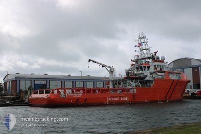
VIKING SENTINEL
Other Type
Current Trip
FISHERIES PATROL
| Time Travelled | 22 days |
|---|---|
| Remaining Time | --- |
| Distance Travelled | 1218.72 nm |
| Remaining Distance | --- |
| AVG Speed | 5.7 Knots |
| MAX Speed | 12.1 Knots |
| AVG Wind | 11.5 knots |
| MAX Wind | 30.9 knots |
| MIN Temp | 9.3°C / 48.74°F |
| MAX Temp | 16.4°C / 61.52°F |
| Draught | 5 m |
| Position Received | 6 h, 13 m ago |
Current Position
| Longitude | -3.48304° |
|---|---|
| Latitude | 50.48767° |
| Status | Under way using engine |
| Speed | 8.2 Knots |
| Course | 313.6° |
| Area | English Channel |
| Station | T-AIS |
| Position Received | 6 h, 13 m ago |
Info
Information
The current position of VIKING SENTINEL is in English Channel with coordinates 50.48767° / -3.48304° as reported on 2024-05-23 17:03 by AIS to our vessel tracker app. The vessel's current speed is 8.2 Knots
The vessel VIKING SENTINEL (IMO: 9720718, MMSI: 232042695) is a Other Type It's sailing under the flag of [GB] United Kingdom.
In this page you can find informations about the vessels current position, last detected port calls, and current voyage information. If the vessels is not in coverage by AIS you will find the latest position.
The current position of VIKING SENTINEL is detected by our AIS receivers and we are not responsible for the reliability of the data. The last position was recorded while the vessel was in Coverage by the Ais receivers of our vessel tracking app.
The current draught of VIKING SENTINEL as reported by AIS is 5 meters
Weather
| Temperature | 13.4°C / 56.12°F |
|---|---|
| Wind Speed | 9 knots |
| Direction | 327° NNW |
| Pressure | 1016.6 hPa |
| Humidity | 69.8 % |
| Cloud Coverage | 99 % |
Featured Company
Last Port Calls
| Port | Arrival | Departure | Time In Port |
|---|---|---|---|
| 2024-04-30 17:32 | 2024-05-01 17:34 | 1 d | |
| 2024-04-02 17:46 | 2024-04-03 18:21 | 1 d | |
| 2024-03-19 20:37 | 2024-03-20 18:42 | 22 h | |
| 2024-03-03 07:35 | 2024-03-08 18:25 | 5 d |
Most Visited Ports (Last year)
| Port | Arrivals | |
|---|---|---|
| 10 | ||
| 2 | ||
| 1 | ||
| 1 | ||
| 1 |
Last Trips
| Origin | Departure | Destination | Arrival | Distance | |
|---|---|---|---|---|---|
| 2024-04-03 19:21 | 2024-04-30 18:32 | 1374.90 nm | |||
| 2024-03-20 18:42 | 2024-04-02 18:46 | 665.71 nm | |||
| 2024-03-08 18:25 | 2024-03-19 20:37 | 791.72 nm | |||
| 2024-02-07 20:35 | 2024-03-03 07:35 | 767.86 nm |
Events
| Time | Event | Details | Position / Dest | Info |
|---|---|---|---|---|
| 2024-05-23 17:03 | OUT of Coverage |
50.48767 / -3.48304
English Channel
|
Speed: 8.2 kn Course: 313.6° |
|
| 2024-05-23 13:51 | START Moving | 15.85 nm, South East of SALCOMBE |
50.04584 / -3.48237
FISHERIES PATROL
|
Speed: 3.1 kn Course: 322° |
| 2024-05-23 13:37 | STOP Moving | 16.11 nm, South East of SALCOMBE |
50.04239 / -3.47831
FISHERIES PATROL
|
Speed: 0.3 kn Course: 8° |
| 2024-05-23 10:08 | START Moving | 20.62 nm, South West of SALCOMBE |
50.00035 / -4.15081
FISHERIES PATROL
|
Speed: 3.8 kn Course: 169° |
| 2024-05-23 10:05 | STOP Moving | 20.56 nm, South West of SALCOMBE |
50.00209 / -4.15155
FISHERIES PATROL
|
Speed: 0.2 kn Course: 63° |
| 2024-05-23 06:18 | START Moving | 5.33 nm, South East of MEVAGISSEY |
50.21703 / -4.67186
FISHERIES PATROL
|
Speed: 3.1 kn Course: 92° |
| 2024-05-22 18:05 | STOP Moving | 1.7 nm, East of MEVAGISSEY |
50.26815 / -4.73981
FISHERIES PATROL
|
Speed: 0.3 kn Course: 36° |
| 2024-05-22 13:37 | IN Coverage |
49.91298 / -4.85258
English Channel
|
Speed: 8 kn Course: 301° |
|
| 2024-05-22 10:51 | OUT of Coverage |
49.76161 / -4.67729
English Channel
|
Speed: 7.8 kn Course: 133.5° |
|
| 2024-05-22 10:37 | IN Coverage |
49.77786 / -4.71101
English Channel
|
Speed: 0.6 kn Course: 89.8° |