
VISION
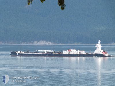
Articulated Pusher Tug
Current Trip
| Time Travelled | 2 days |
|---|---|
| Remaining Time | --- |
| Distance Travelled | 46.20 nm |
| Remaining Distance | --- |
| AVG Speed | 10.8 Knots |
| MAX Speed | 14.7 Knots |
| AVG Wind | 6 knots |
| MAX Wind | 10.4 knots |
| MIN Temp | 11.3°C / 52.34°F |
| MAX Temp | 28.4°C / 83.12°F |
| Draught | 6.1 m |
| Position Received | 7 h, 0 m ago |
Current Position
| Longitude | -122.10029° |
|---|---|
| Latitude | 38.04621° |
| Status | Under way using engine |
| Speed | |
| Course | 241° |
| Area | North Pacific Ocean |
| Station | T-AIS |
| Position Received | 7 h, 0 m ago |
Info
Information
The current position of VISION is in North Pacific Ocean with coordinates 38.04621° / -122.10029° as reported on 2024-06-28 01:13 by AIS to our vessel tracker app. The vessel's current speed is 0 Knots
The vessel VISION (IMO: 9542609, MMSI: 366904000) is a Articulated Pusher Tug that was built in 2010 ( 14 years old ). It's sailing under the flag of [US] USA.
In this page you can find informations about the vessels current position, last detected port calls, and current voyage information. If the vessels is not in coverage by AIS you will find the latest position.
The current position of VISION is detected by our AIS receivers and we are not responsible for the reliability of the data. The last position was recorded while the vessel was in Coverage by the Ais receivers of our vessel tracking app.
The current draught of VISION as reported by AIS is 6.1 meters
Weather
| Temperature | 14.2°C / 57.56°F |
|---|---|
| Wind Speed | 6 knots |
| Direction | 219° SW |
| Pressure | 1009 hPa |
| Humidity | 69 % |
| Cloud Coverage | --- |
Featured Company
Last Port Calls
| Port | Arrival | Departure | Time In Port |
|---|---|---|---|
| 2024-06-24 12:35 | 2024-06-25 14:43 | 1 d | |
| 2024-06-21 04:35 | 2024-06-24 10:11 | 3 d | |
| 2024-06-04 03:37 | 2024-06-04 21:17 | 17 h | |
| 2024-05-26 23:42 | 2024-06-02 01:02 | 6 d | |
| 2024-05-21 18:55 | 2024-05-22 17:40 | 22 h | |
| 2024-05-19 09:08 | 2024-05-20 17:51 | 1 d | |
| 2024-05-18 19:02 | 2024-05-19 07:16 | 12 h | |
| 2024-05-15 00:40 | 2024-05-18 13:22 | 3 d | |
| 2024-05-13 13:39 | 2024-05-14 17:20 | 1 d | |
| 2024-05-11 00:49 | 2024-05-12 11:29 | 1 d |
Most Visited Ports (Last year)
| Port | Arrivals | |
|---|---|---|
| 36 | ||
| 35 | ||
| 13 | ||
| 6 | ||
| 6 | ||
| 4 |
Last Trips
| Origin | Departure | Destination | Arrival | Distance | |
|---|---|---|---|---|---|
| 2024-06-24 03:11 | 2024-06-24 05:35 | 21.27 nm | |||
| 2024-06-04 14:17 | 2024-06-20 21:35 | 92.99 nm | |||
| 2024-06-01 18:02 | 2024-06-03 20:37 | 474.28 nm | |||
| 2024-05-22 10:40 | 2024-05-26 16:42 | 1207.26 nm | |||
| 2024-05-20 10:51 | 2024-05-21 11:55 | 93.88 nm | |||
| 2024-05-19 00:16 | 2024-05-19 02:08 | 22.41 nm | |||
| 2024-05-18 06:22 | 2024-05-18 12:02 | 66.04 nm | |||
| 2024-05-14 10:20 | 2024-05-14 17:40 | 86.19 nm | |||
| 2024-05-12 04:29 | 2024-05-13 06:39 | 105.22 nm | |||
| 2024-05-09 15:37 | 2024-05-10 17:49 | 113.79 nm |
Events
| Time | Event | Details | Position / Dest | Info |
|---|---|---|---|---|
| 2024-06-28 01:23 | Status Changed | Default Under way using engine |
38.04620 / -122.10028
MARTINEZ CA
|
Speed: Course: 241° |
| 2024-06-28 01:13 | Status Changed | Under way using engine Default |
38.04621 / -122.10029
MARTINEZ CA
|
Speed: Course: 241° |
| 2024-06-28 01:13 | OUT of Coverage |
38.04621 / -122.10029
North Pacific Ocean
MARTINEZ CA
|
Speed: Course: 108.4° |
|
| 2024-06-28 01:08 | IN Coverage |
38.04621 / -122.10029
North Pacific Ocean
MARTINEZ CA
|
Speed: Course: 108.4° |
|
| 2024-06-27 22:08 | STOP Moving | 1.87 nm, North East of MARTINEZ |
38.04966 / -122.09458
MARTINEZ CA
|
Speed: 0.1 kn Course: 45° |
| 2024-06-27 21:52 | Status Changed | Default Under way using engine |
38.04607 / -122.10435
MARTINEZ CA
|
Speed: 5 kn Course: 55° |
| 2024-06-27 21:46 | OUT of Coverage |
38.04325 / -122.11128
North Pacific Ocean
MARTINEZ CA
|
Speed: 5 kn Course: 55° |
|
| 2024-06-27 21:46 | Status Changed | Under way using engine Default |
38.04312 / -122.11152
MARTINEZ CA
|
Speed: 8.4 kn Course: 60° |
| 2024-06-27 21:32 | Status Changed | Default Under way using engine |
38.02915 / -122.15390
MARTINEZ CA
|
Speed: 11 kn Course: 142.6° |
| 2024-06-27 21:20 | Status Changed | Under way using engine Default |
38.05279 / -122.18250
MARTINEZ CA
|
Speed: 10.8 kn Course: 117° |