
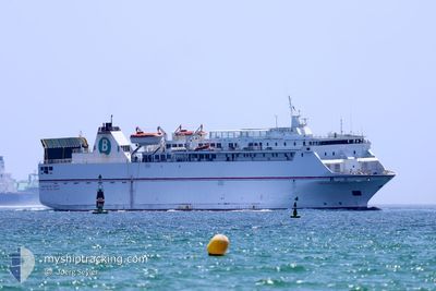
VOLCAN DE TAUCE
Ro-Ro/Passenger Ship
Current Trip
| Time Travelled | 1 day |
|---|---|
| Remaining Time | 7 h, 29 mins |
| Distance Travelled | 605.80 nm |
| Remaining Distance | 128.23 nm |
| AVG Speed | 14.8 Knots |
| MAX Speed | 16.4 Knots |
| AVG Wind | 8.6 knots |
| MAX Wind | 14.8 knots |
| MIN Temp | 17°C / 62.6°F |
| MAX Temp | 20.9°C / 69.62°F |
| Draught | 5 m |
| Position Received | 17 m ago |
Current Position
| Longitude | -14.40146° |
|---|---|
| Latitude | 29.66467° |
| Status | Under way using engine |
| Speed | 15.9 Knots |
| Course | 227.6° |
| Area | North Atlantic Ocean |
| Station | T-AIS |
| Position Received | 17 m ago |
Info
Information
The current position of VOLCAN DE TAUCE is in North Atlantic Ocean with coordinates 29.66467° / -14.40146° as reported on 2024-06-09 22:11 by AIS to our vessel tracker app. The vessel's current speed is 15.9 Knots and is heading at the port of TENERIFE. The estimated time of arrival as calculated by vessel tracking app is 2024-06-10 05:58 LT
The vessel VOLCAN DE TAUCE (IMO: 9081588, MMSI: 224761000) is a Ro-Ro/Passenger Ship that was built in 1995 ( 29 years old ). It's sailing under the flag of [ES] Spain.
In this page you can find informations about the vessels current position, last detected port calls, and current voyage information. If the vessels is not in coverage by AIS you will find the latest position.
The current position of VOLCAN DE TAUCE is detected by our AIS receivers and we are not responsible for the reliability of the data. The last position was recorded while the vessel was in Coverage by the Ais receivers of our vessel tracking app.
The current draught of VOLCAN DE TAUCE as reported by AIS is 5 meters
Weather
| Temperature | 20.8°C / 69.44°F |
|---|---|
| Wind Speed | 11 knots |
| Direction | 347° NNW |
| Pressure | 1017.8 hPa |
| Humidity | 80.2 % |
| Cloud Coverage | 100 % |
Featured Company
Last Port Calls
| Port | Arrival | Departure | Time In Port |
|---|---|---|---|
| 2024-06-07 15:40 | 2024-06-08 06:36 | 14 h | |
| 2024-05-26 16:34 | 2024-06-07 15:36 | 11 d | |
| 2024-05-26 11:56 | 2024-05-26 16:22 | 4 h | |
| 2024-05-25 06:53 | 2024-05-26 04:59 | 22 h | |
| 2024-05-24 19:42 | 2024-05-25 00:01 | 4 h | |
| 2024-05-24 06:38 | 2024-05-24 11:50 | 5 h | |
| 2024-05-23 19:27 | 2024-05-23 23:12 | 3 h | |
| 2024-05-23 06:37 | 2024-05-23 11:50 | 5 h | |
| 2024-05-22 19:50 | 2024-05-22 23:21 | 3 h | |
| 2024-05-22 06:42 | 2024-05-22 12:05 | 5 h |
Most Visited Ports (Last year)
| Port | Arrivals | |
|---|---|---|
| 399 | ||
| 233 | ||
| 190 | ||
| 1 |
Last Trips
| Origin | Departure | Destination | Arrival | Distance | |
|---|---|---|---|---|---|
| 2024-06-07 17:36 | 2024-06-07 17:40 | 0.83 nm | |||
| 2024-05-26 18:22 | 2024-05-26 18:34 | 1.36 nm | |||
| 2024-05-26 06:59 | 2024-05-26 13:56 | 102.40 nm | |||
| 2024-05-25 01:01 | 2024-05-25 08:53 | 110.23 nm | |||
| 2024-05-24 13:50 | 2024-05-24 20:42 | 114.22 nm | |||
| 2024-05-24 00:12 | 2024-05-24 08:38 | 111.27 nm | |||
| 2024-05-23 13:50 | 2024-05-23 20:27 | 113.44 nm | |||
| 2024-05-23 00:21 | 2024-05-23 08:37 | 113.80 nm | |||
| 2024-05-22 14:05 | 2024-05-22 20:50 | 112.96 nm | |||
| 2024-05-22 00:50 | 2024-05-22 08:42 | 110.63 nm |
Events
| Time | Event | Details | Position / Dest | Info |
|---|---|---|---|---|
| 2024-06-09 22:19 | Status Changed | Default Under way using engine |
29.64167 / -14.42833
ESALGESSCT
|
Speed: 15.9 kn Course: 227.6° |
| 2024-06-09 22:11 | Detected in Sea | Spanish (Canary Islands) part of the North Atlantic Ocean |
29.66467 / -14.40146
North Atlantic Ocean
ESALGESSCT
|
Speed: 15.9 kn Course: 227.6° |
| 2024-06-09 22:11 | Status Changed | Under way using engine Default |
29.66467 / -14.40146
ESALGESSCT
|
Speed: 15.5 kn Course: 229° |
| 2024-06-09 21:58 | IN Coverage |
29.66467 / -14.40146
North Atlantic Ocean
ESALGESSCT
|
Speed: 15.9 kn Course: 227.6° |
|
| 2024-06-08 10:31 | Status Changed | Default Under way using engine |
35.68833 / -6.29833
ESALGESSCT
|
Speed: 15.7 kn Course: 228.4° |
| 2024-06-08 10:24 | Status Changed | Under way using engine Default |
35.71081 / -6.26954
ESALGESSCT
|
Speed: 15 kn Course: 228° |
| 2024-06-08 10:24 | IN Coverage |
35.71081 / -6.26954
North Atlantic Ocean
ESALGESSCT
|
Speed: 15.7 kn Course: 228.4° |
|
| 2024-06-08 10:24 | OUT of Coverage |
35.71081 / -6.26954
North Atlantic Ocean
ESALGESSCT
|
Speed: 15.7 kn Course: 228.4° |
|
| 2024-06-08 09:27 | Status Changed | Default Under way using engine |
35.86664 / -6.04157
ESALGESSCT
|
Speed: 15 kn Course: 244.1° |
| 2024-06-08 09:22 | OUT of Coverage |
35.87817 / -6.01714
North Atlantic Ocean
ESALGESSCT
|
Speed: 15 kn Course: 244.1° |