
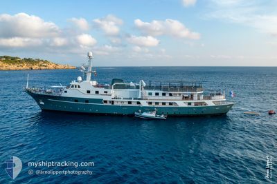
VOYAGER
Pleasure Craft
Current Trip
| Time Travelled | 4 days |
|---|---|
| Remaining Time | --- |
| Distance Travelled | 89.90 nm |
| Remaining Distance | 1.29 nm |
| AVG Speed | 8.9 Knots |
| MAX Speed | 12.4 Knots |
| AVG Wind | 12.1 knots |
| MAX Wind | 23.9 knots |
| MIN Temp | 15.7°C / 60.26°F |
| MAX Temp | 23.5°C / 74.3°F |
| Draught | 4 m |
| Position Received | 2 m ago |
Current Position
| Longitude | 7.05464° |
|---|---|
| Latitude | 43.52615° |
| Status | At anchor |
| Speed | |
| Course | 292° |
| Area | Mediterranean Sea - Western Basin |
| Station | T-AIS |
| Position Received | 2 m ago |
Info
Information
The current position of VOYAGER is in Mediterranean Sea - Western Basin with coordinates 43.52615° / 7.05464° as reported on 2024-05-23 21:50 by AIS to our vessel tracker app. The vessel's current speed is 0 Knots and is heading at the port of CANNES. The estimated time of arrival as calculated by vessel tracking app is 2024-05-20 17:30 LT
The vessel VOYAGER (IMO: 8985957, MMSI: 353270000) is a Pleasure Craft It's sailing under the flag of [PA] Panama.
In this page you can find informations about the vessels current position, last detected port calls, and current voyage information. If the vessels is not in coverage by AIS you will find the latest position.
The current position of VOYAGER is detected by our AIS receivers and we are not responsible for the reliability of the data. The last position was recorded while the vessel was in Coverage by the Ais receivers of our vessel tracking app.
The current draught of VOYAGER as reported by AIS is 4 meters
Weather
| Temperature | 18.2°C / 64.76°F |
|---|---|
| Wind Speed | 13 knots |
| Direction | 253° WSW |
| Pressure | 1015.7 hPa |
| Humidity | 64.2 % |
| Cloud Coverage | --- |
Featured Company
Last Port Calls
| Port | Arrival | Departure | Time In Port |
|---|---|---|---|
| 2024-05-13 19:23 | 2024-05-19 08:43 | 5 d | |
| 2024-05-10 11:57 |
Most Visited Ports (Last year)
| Port | Arrivals | |
|---|---|---|
| 3 | ||
| 2 | ||
| 2 | ||
| 1 |
Last Trips
| Origin | Departure | Destination | Arrival | Distance | |
|---|---|---|---|---|---|
| 2024-05-10 13:57 | 2024-05-13 21:23 | 193.50 nm |
Events
| Time | Event | Details | Position / Dest | Info |
|---|---|---|---|---|
| 2024-05-20 15:42 | Status Changed | At anchor Under way using engine |
43.52607 / 7.05261
CANNES ANCH
|
Speed: 0.1 kn Course: 131° |
| 2024-05-20 15:33 | STOP Moving | 1.62 nm, South East of CANNES |
43.52618 / 7.05359
CANNES ANCH
|
Speed: 0.1 kn Course: 108° |
| 2024-05-20 13:02 | Status Changed | Under way using engine At anchor |
43.28401 / 6.64321
CANNES ANCH
|
Speed: 12.1 kn Course: 51.8° |
| 2024-05-20 12:57 | START Moving | 0.35 nm, West of SAINT TROPEZ |
43.27281 / 6.62657
CANNES ANCH
|
Speed: 4.8 kn Course: 37° |
| 2024-05-20 12:50 | Destination Changed | CANNES ANCH ST TROPEZ |
43.27150 / 6.62729
CANNES ANCH
|
Speed: 0.4 kn Course: 353° |
| 2024-05-20 12:50 | ETA Changed | 2024/05/20 17:30 2024/05/19 14:00 |
43.27150 / 6.62729
CANNES ANCH
|
Speed: 0.4 kn Course: 353° |
| 2024-05-19 13:56 | Status Changed | At anchor Under way using engine |
43.27077 / 6.62751
ST TROPEZ
|
Speed: 0.3 kn Course: 73° |
| 2024-05-19 13:55 | STOP Moving | 0.32 nm, West of SAINT TROPEZ |
43.27074 / 6.62746
ST TROPEZ
|
Speed: 0.3 kn Course: 73° |
| 2024-05-19 11:53 | IN Coverage |
43.08200 / 6.58172
Mediterranean Sea - Western Basin
ST TROPEZ
|
Speed: 11.9 kn Course: 39.2° |
|
| 2024-05-19 09:58 | OUT of Coverage |
42.98952 / 6.12638
Mediterranean Sea - Western Basin
ST TROPEZ
|
Speed: 12 kn Course: 119.6° |