
WAGON B
General Cargo
Current Trip
| Time Travelled | 26 days |
|---|---|
| Remaining Time | 7 days |
| Distance Travelled | 2595.21 nm |
| Remaining Distance | 1391.83 nm |
| AVG Speed | 7.3 Knots |
| MAX Speed | 12.2 Knots |
| AVG Wind | 10.5 knots |
| MAX Wind | 27.8 knots |
| MIN Temp | 9.5°C / 49.1°F |
| MAX Temp | 28°C / 82.4°F |
| Draught | 6.5 m |
| Position Received | 10 h, 11 m ago |
Current Position
| Longitude | -5.59155° |
|---|---|
| Latitude | 35.97702° |
| Status | Under way using engine |
| Speed | 8.3 Knots |
| Course | 258.1° |
| Area | Strait of Gibraltar |
| Station | T-AIS |
| Position Received | 10 h, 11 m ago |
Info
Information
The current position of WAGON B is in Strait of Gibraltar with coordinates 35.97702° / -5.59155° as reported on 2024-05-23 12:32 by AIS to our vessel tracker app. The vessel's current speed is 8.3 Knots and is heading at the port of VLAARDINGEN - ROTTERDAM. The estimated time of arrival as calculated by vessel tracking app is 2024-05-31 04:21 LT
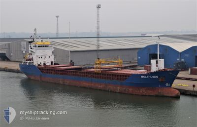
The vessel WAGON B (IMO: 9115925, MMSI: 305748000) is a General Cargo that was built in 1995 ( 29 years old ). It's sailing under the flag of [AG] Antigua Barbuda.
In this page you can find informations about the vessels current position, last detected port calls, and current voyage information. If the vessels is not in coverage by AIS you will find the latest position.
The current position of WAGON B is detected by our AIS receivers and we are not responsible for the reliability of the data. The last position was recorded while the vessel was in Coverage by the Ais receivers of our vessel tracking app.
The current draught of WAGON B as reported by AIS is 6.5 meters
Weather
| Temperature | 19.2°C / 66.56°F |
|---|---|
| Wind Speed | 9 knots |
| Direction | 312° NW |
| Pressure | 1014 hPa |
| Humidity | 74.1 % |
| Cloud Coverage | 95 % |
Featured Company
Last Port Calls
| Port | Arrival | Departure | Time In Port |
|---|---|---|---|
| 2024-04-26 12:32 | 2024-04-27 21:26 | 1 d | |
| 2024-04-17 06:56 | 2024-04-23 22:19 | 6 d | |
| 2024-04-07 18:30 | 2024-04-09 07:17 | 1 d | |
| 2024-04-02 16:40 | 2024-04-03 23:28 | 1 d | |
| 2024-03-21 11:31 | 2024-03-24 22:24 | 3 d | |
| 2024-03-07 14:24 | 2024-03-11 19:11 | 4 d | |
| 2024-03-02 10:12 |
Most Visited Ports (Last year)
| Port | Arrivals | |
|---|---|---|
| 3 | ||
| 3 | ||
| 2 | ||
| 1 | ||
| 1 | ||
| 1 |
Last Trips
| Origin | Departure | Destination | Arrival | Distance | |
|---|---|---|---|---|---|
| 2024-04-24 01:19 | 2024-04-26 15:32 | 467.11 nm | |||
| 2024-04-09 10:17 | 2024-04-17 09:56 | 881.57 nm | |||
| 2024-04-04 02:28 | 2024-04-07 21:30 | 864.20 nm | |||
| 2024-03-24 23:24 | 2024-04-02 19:40 | 1826.01 nm | |||
| 2024-03-11 20:11 | 2024-03-21 12:31 | 1881.50 nm | |||
| 2024-03-02 10:12 | 2024-03-07 15:24 | 949.99 nm |
Events
| Time | Event | Details | Position / Dest | Info |
|---|---|---|---|---|
| 2024-05-23 12:38 | Status Changed | Default Under way using engine |
35.97400 / -5.60833
NLVLA
|
Speed: 8.3 kn Course: 258.1° |
| 2024-05-23 12:32 | OUT of Coverage |
35.97702 / -5.59155
Strait of Gibraltar
NLVLA
|
Speed: 8.3 kn Course: 258.1° |
|
| 2024-05-23 11:03 | Status Changed | Under way using engine Default |
36.01339 / -5.36156
NLVLA
|
Speed: 7.3 kn Course: 256° |
| 2024-05-23 10:59 | Status Changed | Default Under way using engine |
36.01516 / -5.34948
NLVLA
|
Speed: 7.4 kn Course: 257.9° |
| 2024-05-23 10:53 | Change Sea Area | Spanish part of the Strait of Gibraltar Gibraltarian part of the Alboran Sea |
36.01695 / -5.33624
Strait of Gibraltar
NLVLA
|
Speed: 7.4 kn Course: 257.9° |
| 2024-05-23 10:53 | Status Changed | Under way using engine Default |
36.01710 / -5.33537
NLVLA
|
Speed: 7.4 kn Course: 256° |
| 2024-05-23 10:30 | Status Changed | Default Under way using engine |
36.03066 / -5.28000
NLVLA
|
Speed: 7.6 kn Course: 240° |
| 2024-05-23 10:21 | Status Changed | Under way using engine Default |
36.04014 / -5.25542
NLVLA
|
Speed: 7.1 kn Course: 235° |
| 2024-05-23 10:10 | Status Changed | Default Under way using engine |
36.04619 / -5.23256
NLVLA
|
Speed: 7.4 kn Course: 262.6° |
| 2024-05-23 10:08 | Status Changed | Under way using engine Default |
36.04680 / -5.22567
NLVLA
|
Speed: 7.1 kn Course: 262° |