
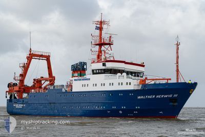
WALTHER HERWIG III
Fishery Research Vessel
Current Trip
BALTIC SEA SURVEY
| Time Travelled | 9 days |
|---|---|
| Remaining Time | --- |
| Distance Travelled | 1055.28 nm |
| Remaining Distance | --- |
| AVG Speed | 7.9 Knots |
| MAX Speed | 12.3 Knots |
| AVG Wind | 9.6 knots |
| MAX Wind | 20.2 knots |
| MIN Temp | 3.7°C / 38.66°F |
| MAX Temp | 11.6°C / 52.88°F |
| Draught | 6.2 m |
| Position Received | 1 d ago |
Current Position
| Longitude | 19.74744° |
|---|---|
| Latitude | 58.38621° |
| Status | Restricted manoeuverability |
| Speed | 0.6 Knots |
| Course | 47° |
| Area | Baltic Sea |
| Station | T-AIS |
| Position Received | 1 d ago |
Info
Information
The current position of WALTHER HERWIG III is in Baltic Sea with coordinates 58.38621° / 19.74744° as reported on 2024-05-12 07:03 by AIS to our vessel tracker app. The vessel's current speed is 0.6 Knots
The vessel WALTHER HERWIG III (IMO: 9048392, MMSI: 211215500) is a Fishery Research Vessel that was built in 1993 ( 31 years old ). It's sailing under the flag of [DE] Germany.
In this page you can find informations about the vessels current position, last detected port calls, and current voyage information. If the vessels is not in coverage by AIS you will find the latest position.
The current position of WALTHER HERWIG III is detected by our AIS receivers and we are not responsible for the reliability of the data. The last position was recorded while the vessel was in Coverage by the Ais receivers of our vessel tracking app.
The current draught of WALTHER HERWIG III as reported by AIS is 6.2 meters
Weather
| Temperature | 6.2°C / 43.16°F |
|---|---|
| Wind Speed | 6 knots |
| Direction | 228° SW |
| Pressure | 1024.8 hPa |
| Humidity | 87.4 % |
| Cloud Coverage | 34 % |
Featured Company
Last Port Calls
| Port | Arrival | Departure | Time In Port |
|---|---|---|---|
| 2024-05-04 06:20 | 2024-05-04 10:21 | 4 h | |
| 2024-04-07 21:50 | 2024-05-02 05:06 | 24 d | |
| 2024-03-27 13:21 | 2024-04-03 07:15 | 6 d | |
| 2024-03-25 14:16 |
Most Visited Ports (Last year)
| Port | Arrivals | |
|---|---|---|
| 121 | ||
| 45 | ||
| 2 |
Last Trips
| Origin | Departure | Destination | Arrival | Distance | |
|---|---|---|---|---|---|
| 2024-05-02 07:06 | 2024-05-04 08:20 | 569.92 nm | |||
| 2024-04-03 09:15 | 2024-04-07 23:50 | 475.19 nm | |||
| 2024-03-25 15:16 | 2024-03-27 14:21 | 112.96 nm |
Events
| Time | Event | Details | Position / Dest | Info |
|---|---|---|---|---|
| 2024-05-12 07:03 | OUT of Coverage |
58.38621 / 19.74744
Baltic Sea
|
Speed: 0.6 kn Course: 8.3° |
|
| 2024-05-12 04:20 | IN Coverage |
58.49484 / 19.75423
Baltic Sea
|
Speed: 2.1 kn Course: 223.2° |
|
| 2024-05-12 02:15 | OUT of Coverage |
58.57677 / 19.57908
Baltic Sea
|
Speed: 0.9 kn Course: 139.4° |
|
| 2024-05-11 19:16 | Status Changed | Under way using engine Restricted manoeuverability |
58.56025 / 19.61306
BALTIC SEA SURVEY
|
Speed: 0.9 kn Course: 91° |
| 2024-05-11 18:23 | IN Coverage |
58.62470 / 19.47084
Baltic Sea
|
Speed: 4.4 kn Course: 267.6° |
|
| 2024-05-11 17:23 | OUT of Coverage |
58.62479 / 19.78661
Baltic Sea
|
Speed: 10 kn Course: 269.7° |
|
| 2024-05-11 15:46 | IN Coverage |
58.62559 / 20.23377
Baltic Sea
|
Speed: 9.7 kn Course: 270.7° |
|
| 2024-05-11 10:32 | OUT of Coverage |
58.87372 / 20.12981
Baltic Sea
|
Speed: 3.9 kn Course: 94.8° |
|
| 2024-05-11 10:01 | IN Coverage |
58.87495 / 20.05873
Baltic Sea
|
Speed: 8.4 kn Course: 89.6° |
|
| 2024-05-11 08:51 | OUT of Coverage |
58.87257 / 19.70729
Baltic Sea
|
Speed: 1 kn Course: 216° |