
WATER LADY
Tug
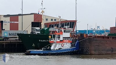
Current Trip
DEN OEVER
| Time Travelled | 1 day |
|---|---|
| Remaining Time | --- |
| Distance Travelled | 8.21 nm |
| Remaining Distance | --- |
| AVG Speed | 6.2 Knots |
| MAX Speed | 8.2 Knots |
| AVG Wind | 10.2 knots |
| MAX Wind | 10.9 knots |
| MIN Temp | 13.3°C / 55.94°F |
| MAX Temp | 13.7°C / 56.66°F |
| Draught | 2.2 m |
| Position Received | 5 m ago |
Current Position
| Longitude | 5.04065° |
|---|---|
| Latitude | 52.92244° |
| Status | Moored |
| Speed | |
| Course | --- |
| Area | North Sea |
| Station | T-AIS |
| Position Received | 5 m ago |
Info
Information
The current position of WATER LADY is in North Sea with coordinates 52.92244° / 5.04065° as reported on 2024-06-01 02:14 by AIS to our vessel tracker app. The vessel's current speed is 0 Knots
The vessel WATER LADY (MMSI: 244710819) is a Tug It's sailing under the flag of [NL] Netherlands.
In this page you can find informations about the vessels current position, last detected port calls, and current voyage information. If the vessels is not in coverage by AIS you will find the latest position.
The current position of WATER LADY is detected by our AIS receivers and we are not responsible for the reliability of the data. The last position was recorded while the vessel was in Coverage by the Ais receivers of our vessel tracking app.
The current draught of WATER LADY as reported by AIS is 2.2 meters
Weather
| Temperature | 14.4°C / 57.92°F |
|---|---|
| Wind Speed | 21 knots |
| Direction | 1° N |
| Pressure | 1015.3 hPa |
| Humidity | 91.2 % |
| Cloud Coverage | 100 % |
Featured Company
Last Port Calls
| Port | Arrival | Departure | Time In Port |
|---|---|---|---|
| 2024-05-30 05:15 | 2024-05-30 14:44 | 9 h | |
| 2024-05-29 14:38 | 2024-05-29 14:53 | 15 m | |
| 2024-05-29 11:46 | 2024-05-29 13:05 | 1 h | |
| 2024-05-29 07:16 | 2024-05-29 11:35 | 4 h | |
| 2024-05-25 06:22 | 2024-05-25 09:03 | 2 h | |
| 2024-05-23 09:45 | 2024-05-25 05:04 | 1 d | |
| 2024-05-22 16:34 | 2024-05-23 05:15 | 12 h | |
| 2024-05-22 14:50 | 2024-05-22 15:04 | 14 m | |
| 2024-05-22 12:54 | 2024-05-22 13:37 | 43 m | |
| 2024-05-22 12:02 | 2024-05-22 12:31 | 29 m |
Last Trips
| Origin | Departure | Destination | Arrival | Distance | |
|---|---|---|---|---|---|
| 2024-05-29 16:53 | 2024-05-30 07:15 | 14.26 nm | |||
| 2024-05-29 15:05 | 2024-05-29 16:38 | 1.12 nm | |||
| 2024-05-29 13:35 | 2024-05-29 13:46 | 0.77 nm | |||
| 2024-05-25 11:03 | 2024-05-29 09:16 | 104.75 nm | |||
| 2024-05-25 07:04 | 2024-05-25 08:22 | 10.51 nm | |||
| 2024-05-23 07:15 | 2024-05-23 11:45 | 24.72 nm | |||
| 2024-05-22 17:04 | 2024-05-22 18:34 | 0.79 nm | |||
| 2024-05-22 15:37 | 2024-05-22 16:50 | 3.78 nm | |||
| 2024-05-22 14:31 | 2024-05-22 14:54 | 0.71 nm | |||
| 2024-05-22 13:10 | 2024-05-22 14:02 | 2.47 nm |
Events
| Time | Event | Details | Position / Dest | Info |
|---|---|---|---|---|
| 2024-05-31 10:20 | Status Changed | Moored Under way using engine |
52.92243 / 5.04066
DEN OEVER
|
Speed: Course: 511° |
| 2024-05-30 17:35 | STOP Moving | 0.19 nm, South West of MARINA DEN OEVER |
52.92246 / 5.04068
DEN OEVER
|
Speed: 0.3 kn Course: 511° |
| 2024-05-30 17:17 | START Moving | 1.2 nm, South East of MARINA DEN OEVER |
52.91010 / 5.06965
DEN OEVER
|
Speed: 6.2 kn Course: 347.2° |
| 2024-05-30 17:12 | STOP Moving | 1.31 nm, South East of MARINA DEN OEVER |
52.90814 / 5.07076
DEN OEVER
|
Speed: 0.3 kn Course: 511° |
| 2024-05-30 16:51 | START Moving | 0.55 nm, East of DEN OEVER |
52.93556 / 5.05258
DEN OEVER
|
Speed: 7.2 kn Course: 106.5° |
| 2024-05-30 16:30 | STOP Moving | 0.49 nm, East of DEN OEVER |
52.93711 / 5.05107
DEN OEVER
|
Speed: 0.3 kn Course: 511° |
| 2024-05-30 16:25 | START Moving | 0.41 nm, East of DEN OEVER |
52.93552 / 5.04851
DEN OEVER
|
Speed: 3.1 kn Course: 51.8° |
| 2024-05-30 15:28 | STOP Moving | 0.34 nm, South East of DEN OEVER |
52.93456 / 5.04580
DEN OEVER
|
Speed: 0.3 kn Course: 511° |
| 2024-05-30 15:23 | START Moving | 0.75 nm, East of DEN OEVER |
52.93447 / 5.05764
DEN OEVER
|
Speed: 7.5 kn Course: 276.5° |
| 2024-05-30 15:20 | STOP Moving | 0.81 nm, North East of MARINA DEN OEVER |
52.93378 / 5.06051
DEN OEVER
|
Speed: 0.2 kn Course: 511° |