
WILLI RAAB
Cargo
Current Trip
| Time Travelled | 1 day |
|---|---|
| Remaining Time | --- |
| Distance Travelled | 34.13 nm |
| Remaining Distance | --- |
| AVG Speed | 5.2 Knots |
| MAX Speed | 7.6 Knots |
| AVG Wind | 5.1 knots |
| MAX Wind | 13.5 knots |
| MIN Temp | 18.9°C / 66.02°F |
| MAX Temp | 20.7°C / 69.26°F |
| Draught | 2.5 m |
| Position Received | 10 h, 43 m ago |
Current Position
| Longitude | 8.14407° |
|---|---|
| Latitude | 52.40873° |
| Status | Under way using engine |
| Speed | 5.3 Knots |
| Course | 132.3° |
| Area | North Sea |
| Station | T-AIS |
| Position Received | 10 h, 43 m ago |
Info
Information
The current position of WILLI RAAB is in North Sea with coordinates 52.40873° / 8.14407° as reported on 2024-06-29 08:53 by AIS to our vessel tracker app. The vessel's current speed is 5.3 Knots and is heading at the port of VAHLDORF. The estimated time of arrival as calculated by vessel tracking app is 2024-07-02 14:00 LT
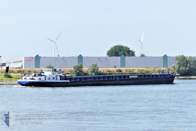
The vessel WILLI RAAB (MMSI: 211506970) is a Cargo It's sailing under the flag of [DE] Germany.
In this page you can find informations about the vessels current position, last detected port calls, and current voyage information. If the vessels is not in coverage by AIS you will find the latest position.
The current position of WILLI RAAB is detected by our AIS receivers and we are not responsible for the reliability of the data. The last position was recorded while the vessel was in Coverage by the Ais receivers of our vessel tracking app.
The current draught of WILLI RAAB as reported by AIS is 2.5 meters
Weather
| Temperature | 19.6°C / 67.28°F |
|---|---|
| Wind Speed | 5 knots |
| Direction | 91° E |
| Pressure | 1016.5 hPa |
| Humidity | 70.3 % |
| Cloud Coverage | 64 % |
Featured Company
Last Port Calls
| Port | Arrival | Departure | Time In Port |
|---|---|---|---|
| 2024-06-28 10:29 | 2024-06-28 10:50 | 20 m | |
| 2024-06-27 09:15 | 2024-06-28 01:24 | 16 h | |
| 2024-06-26 15:44 | 2024-06-27 04:47 | 13 h | |
| 2024-06-19 16:25 | 2024-06-20 04:10 | 11 h | |
| 2024-06-13 14:24 | |||
| 2024-06-12 06:56 | 2024-06-12 07:21 | 24 m | |
| 2024-06-07 15:54 | 2024-06-08 04:20 | 12 h | |
| 2024-06-07 05:17 | 2024-06-07 07:22 | 2 h | |
| 2024-06-04 05:17 | 2024-06-06 20:38 | 2 d | |
| 2024-05-23 15:30 | 2024-05-24 05:49 | 14 h |
Last Trips
| Origin | Departure | Destination | Arrival | Distance | |
|---|---|---|---|---|---|
| 2024-06-28 03:24 | 2024-06-28 12:29 | 1.82 nm | |||
| 2024-06-27 06:47 | 2024-06-27 11:15 | 40.30 nm | |||
| 2024-06-20 06:10 | 2024-06-26 17:44 | 61.26 nm | |||
| 2024-06-12 09:21 | 2024-06-13 16:24 | 5.67 nm | |||
| 2024-06-08 06:20 | 2024-06-12 08:56 | 128.94 nm | |||
| 2024-06-07 09:22 | 2024-06-07 17:54 | 34.03 nm | |||
| 2024-06-06 22:38 | 2024-06-07 07:17 | 1.56 nm | |||
| 2024-05-24 07:49 | 2024-06-04 07:17 | 306.90 nm | |||
| 2024-05-23 10:58 | 2024-05-23 17:30 | 28.48 nm | |||
| 2024-05-23 06:06 | 2024-05-23 10:39 | 0.98 nm |
Events
| Time | Event | Details | Position / Dest | Info |
|---|---|---|---|---|
| 2024-06-29 08:53 | OUT of Coverage |
52.40873 / 8.14407
North Sea
VAHLDORF
|
Speed: 5.3 kn Course: 132.3° |
|
| 2024-06-29 07:33 | IN Coverage |
52.39256 / 7.96002
North Sea
VAHLDORF
|
Speed: 4.4 kn Course: 76° |
|
| 2024-06-28 10:56 | OUT of Coverage |
51.98563 / 7.66034
North Sea
VAHLDORF
|
Speed: 5.3 kn Course: 355.1° |
|
| 2024-06-28 10:53 | START Moving | 1.36 nm, South of COERHEIDE |
51.98110 / 7.66117
VAHLDORF
|
Speed: 4.3 kn Course: 349.5° |
| 2024-06-28 10:50 | PORT DEPARTURE |
|
51.98110 / 7.66117
VAHLDORF
|
Speed: Course: 511° |
| 2024-06-28 10:30 | STOP Moving |
51.97767 / 7.66205
[DE] MUNSTER
|
Speed: 0.3 kn Course: 511° |
|
| 2024-06-28 10:29 | PORT ARRIVAL |
|
51.97761 / 7.66207
[DE] MUNSTER
|
Speed: 0.6 kn Course: 511° |
| 2024-06-28 10:18 | ETA Changed | 2024/07/02 14:00 2025/01/03 15:00 |
51.97214 / 7.66350
VAHLDORF
|
Speed: 1.5 kn Course: 511° |
| 2024-06-28 09:55 | IN Coverage |
51.95088 / 7.64984
North Sea
|
Speed: 5.1 kn Course: 41.8° |
|
| 2024-06-28 01:24 | PORT DEPARTURE |
|
51.95088 / 7.64984
VAHLDORF
|
Speed: 5.5 kn Course: 48.4° |