
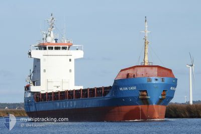
WILSON CADIZ
General Cargo
Current Trip
| Time Travelled | 13 h, 1 mins |
|---|---|
| Remaining Time | 3 days |
| Distance Travelled | 132.45 nm |
| Remaining Distance | 655.54 nm |
| AVG Speed | 9.4 Knots |
| MAX Speed | 12.4 Knots |
| AVG Wind | 7.8 knots |
| MAX Wind | 9 knots |
| MIN Temp | 13.7°C / 56.66°F |
| MAX Temp | 16.8°C / 62.24°F |
| Draught | 5.9 m |
| Position Received | 1 m ago |
Current Position
| Longitude | 1.34019° |
|---|---|
| Latitude | 51.00626° |
| Status | Under way using engine |
| Speed | 9.6 Knots |
| Course | 232° |
| Area | English Channel |
| Station | T-AIS |
| Position Received | 1 m ago |
Info
Information
The current position of WILSON CADIZ is in English Channel with coordinates 51.00626° / 1.34019° as reported on 2024-06-23 03:16 by AIS to our vessel tracker app. The vessel's current speed is 9.6 Knots and is heading at the port of PASAJES. The estimated time of arrival as calculated by vessel tracking app is 2024-06-26 12:32 LT
The vessel WILSON CADIZ (IMO: 9192612, MMSI: 314216000) is a General Cargo that was built in 2000 ( 24 years old ). It's sailing under the flag of [BB] Barbados.
In this page you can find informations about the vessels current position, last detected port calls, and current voyage information. If the vessels is not in coverage by AIS you will find the latest position.
The current position of WILSON CADIZ is detected by our AIS receivers and we are not responsible for the reliability of the data. The last position was recorded while the vessel was in Coverage by the Ais receivers of our vessel tracking app.
The current draught of WILSON CADIZ as reported by AIS is 5.9 meters
Weather
| Temperature | 13.7°C / 56.66°F |
|---|---|
| Wind Speed | 6 knots |
| Direction | 288° WNW |
| Pressure | 1017.8 hPa |
| Humidity | 81.7 % |
| Cloud Coverage | 3 % |
Featured Company
Last Port Calls
| Port | Arrival | Departure | Time In Port |
|---|---|---|---|
| 2024-06-20 23:48 | 2024-06-22 14:16 | 1 d | |
| 2024-06-17 15:11 | 2024-06-20 14:42 | 2 d | |
| 2024-06-04 05:12 | 2024-06-05 19:05 | 1 d | |
| 2024-05-29 04:21 | 2024-05-30 13:14 | 1 d | |
| 2024-05-27 08:45 | 2024-05-28 04:53 | 20 h | |
| 2024-05-20 15:33 | 2024-05-22 19:15 | 2 d | |
| 2024-05-08 22:37 | 2024-05-13 13:51 | 4 d | |
| 2024-05-05 15:00 | 2024-05-05 22:47 | 7 h | |
| 2024-04-30 17:38 | 2024-05-01 19:26 | 1 d | |
| 2024-04-28 08:05 | 2024-04-29 21:12 | 1 d |
Most Visited Ports (Last year)
| Port | Arrivals | |
|---|---|---|
| 5 | ||
| 3 | ||
| 3 | ||
| 3 | ||
| 3 | ||
| 3 |
Last Trips
| Origin | Departure | Destination | Arrival | Distance | |
|---|---|---|---|---|---|
| 2024-06-20 16:42 | 2024-06-21 01:48 | 73.92 nm | |||
| 2024-06-05 21:05 | 2024-06-17 17:11 | 1943.81 nm | |||
| 2024-05-30 15:14 | 2024-06-04 07:12 | 1107.83 nm | |||
| 2024-05-28 06:53 | 2024-05-29 06:21 | 213.57 nm | |||
| 2024-05-22 21:15 | 2024-05-27 10:45 | 557.59 nm | |||
| 2024-05-05 22:47 | 2024-05-20 17:33 | 1354.24 nm | |||
| 2024-05-05 22:47 | 2024-05-08 23:37 | 817.65 nm | |||
| 2024-05-01 20:26 | 2024-05-05 15:00 | 870.56 nm | |||
| 2024-04-29 22:12 | 2024-04-30 18:38 | 226.43 nm | |||
| 2024-04-24 22:59 | 2024-04-28 09:05 | 810.02 nm |
Events
| Time | Event | Details | Position / Dest | Info |
|---|---|---|---|---|
| 2024-06-23 02:35 | Change Sea Area | United Kingdom part of the English Channel United Kingdom part of the North Sea |
51.07511 / 1.47042
English Channel
ESPAS
|
Speed: 8.9 kn Course: 230.2° |
| 2024-06-22 20:19 | Change Sea Area | United Kingdom part of the North Sea Belgian part of the North Sea |
51.86478 / 2.53123
North Sea
ESPAS
|
Speed: 11.9 kn Course: 227.4° |
| 2024-06-22 20:17 | Change Sea Area | Belgian part of the North Sea Dutch part of the North Sea |
51.86953 / 2.53957
North Sea
ESPAS
|
Speed: 11.6 kn Course: 228.8° |
| 2024-06-22 17:13 | Status Changed | Under way using engine Default |
52.04907 / 3.37497
ESPAS
|
Speed: 10.5 kn Course: 279° |
| 2024-06-22 17:06 | Status Changed | Default Under way using engine |
52.04474 / 3.40595
ESPAS
|
Speed: 10.6 kn Course: 270.3° |
| 2024-06-22 16:32 | Status Changed | Under way using engine Default |
52.04794 / 3.56523
ESPAS
|
Speed: 10.2 kn Course: 274° |
| 2024-06-22 16:02 | Status Changed | Default Under way using engine |
52.04288 / 3.69888
ESPAS
|
Speed: 9.9 kn Course: 276.7° |
| 2024-06-22 15:55 | Status Changed | Under way using engine Default |
52.04130 / 3.73156
ESPAS
|
Speed: 9.8 kn Course: 276° |
| 2024-06-22 15:47 | Status Changed | Default Under way using engine |
52.03936 / 3.76443
ESPAS
|
Speed: 9.7 kn Course: 276° |
| 2024-06-22 14:16 | PORT DEPARTURE |
|
51.96256 / 4.08212
ESPAS
|
Speed: 10.7 kn Course: 56° |