
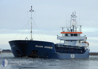
WILSON DAVANGER
General Cargo
Current Trip
| Time Travelled | 1 day |
|---|---|
| Remaining Time | 2 days |
| Distance Travelled | 381.40 nm |
| Remaining Distance | 527.42 nm |
| AVG Speed | 11.3 Knots |
| MAX Speed | 15.3 Knots |
| AVG Wind | 9.3 knots |
| MAX Wind | 15.1 knots |
| MIN Temp | 11.6°C / 52.88°F |
| MAX Temp | 17.4°C / 63.32°F |
| Draught | 5.8 m |
| Position Received | Now |
Current Position
| Longitude | 1.58572° |
|---|---|
| Latitude | 51.13843° |
| Status | Under way using engine |
| Speed | 8.7 Knots |
| Course | 226.3° |
| Area | North Sea |
| Station | T-AIS |
| Position Received | Now |
Info
Information
The current position of WILSON DAVANGER is in North Sea with coordinates 51.13843° / 1.58572° as reported on 2024-05-19 08:26 by AIS to our vessel tracker app. The vessel's current speed is 8.7 Knots and is heading at the port of BELFAST. The estimated time of arrival as calculated by vessel tracking app is 2024-05-21 14:29 LT
The vessel WILSON DAVANGER (IMO: 9390111, MMSI: 314618000) is a General Cargo that was built in 2008 ( 16 years old ). It's sailing under the flag of [BB] Barbados.
In this page you can find informations about the vessels current position, last detected port calls, and current voyage information. If the vessels is not in coverage by AIS you will find the latest position.
The current position of WILSON DAVANGER is detected by our AIS receivers and we are not responsible for the reliability of the data. The last position was recorded while the vessel was in Coverage by the Ais receivers of our vessel tracking app.
The current draught of WILSON DAVANGER as reported by AIS is 5.8 meters
Weather
| Temperature | 12.9°C / 55.22°F |
|---|---|
| Wind Speed | 8 knots |
| Direction | 338° NNW |
| Pressure | 1013.4 hPa |
| Humidity | 90.1 % |
| Cloud Coverage | 36 % |
Featured Company
Last Port Calls
| Port | Arrival | Departure | Time In Port |
|---|---|---|---|
| 2024-05-17 02:40 | 2024-05-17 20:11 | 17 h | |
| 2024-05-13 17:36 | 2024-05-14 17:15 | 23 h | |
| 2024-05-06 10:43 | 2024-05-07 04:22 | 17 h | |
| 2024-05-01 09:35 | 2024-05-05 15:48 | 4 d | |
| 2024-04-25 08:06 | 2024-04-26 05:41 | 21 h | |
| 2024-04-10 05:05 | 2024-04-11 20:02 | 1 d | |
| 2024-04-09 06:25 | 2024-04-09 11:21 | 4 h | |
| 2024-04-05 05:24 | 2024-04-07 00:05 | 1 d | |
| 2024-03-31 07:44 | 2024-03-31 07:47 | 3 m | |
| 2024-03-26 02:23 | 2024-03-28 15:48 | 2 d |
Last Trips
| Origin | Departure | Destination | Arrival | Distance | |
|---|---|---|---|---|---|
| 2024-05-14 19:15 | 2024-05-17 04:40 | 314.79 nm | |||
| 2024-05-07 06:22 | 2024-05-13 19:36 | 1038.60 nm | |||
| 2024-05-05 17:48 | 2024-05-06 12:43 | 195.00 nm | |||
| 2024-04-26 07:41 | 2024-05-01 11:35 | 1136.09 nm | |||
| 2024-04-11 22:02 | 2024-04-25 10:06 | 2286.57 nm | |||
| 2024-04-09 13:21 | 2024-04-10 07:05 | 125.81 nm | |||
| 2024-04-07 03:05 | 2024-04-09 08:25 | 462.50 nm | |||
| 2024-03-31 09:47 | 2024-04-05 08:24 | 800.79 nm | |||
| 2024-03-28 16:48 | 2024-03-31 09:44 | 605.57 nm | |||
| 2024-03-23 14:46 | 2024-03-26 03:23 | 485.12 nm |
Events
| Time | Event | Details | Position / Dest | Info |
|---|---|---|---|---|
| 2024-05-19 03:05 | Detected in Sea | United Kingdom part of the North Sea |
51.86923 / 2.53795
North Sea
GBBEL
|
Speed: 10.4 kn Course: 219.7° |
| 2024-05-19 00:30 | Status Changed | Under way using engine Default |
52.19361 / 2.96655
GBBEL
|
Speed: 9.1 kn Course: 216° |
| 2024-05-19 00:22 | Status Changed | Default Under way using engine |
52.20996 / 2.98580
GBBEL
|
Speed: 9 kn Course: 215.9° |
| 2024-05-19 00:04 | Status Changed | Under way using engine Default |
52.24733 / 3.02975
GBBEL
|
Speed: 9.1 kn Course: 216° |
| 2024-05-18 23:57 | Status Changed | Default Under way using engine |
52.26042 / 3.04503
GBBEL
|
Speed: 9 kn Course: 215.3° |
| 2024-05-18 23:52 | Status Changed | Under way using engine Default |
52.27107 / 3.05734
GBBEL
|
Speed: 9 kn Course: 216° |
| 2024-05-18 23:33 | IN Coverage |
52.27087 / 3.05711
North Sea
GBBEL
|
Speed: 8.9 kn Course: 215.8° |
|
| 2024-05-18 21:12 | Status Changed | Default Under way using engine |
52.60684 / 3.45780
GBBEL
|
Speed: 10.3 kn Course: 222° |
| 2024-05-18 21:06 | Status Changed | Under way using engine Default |
52.62076 / 3.47847
GBBEL
|
Speed: 10.3 kn Course: 222° |
| 2024-05-18 21:06 | OUT of Coverage |
52.62076 / 3.47847
North Sea
GBBEL
|
Speed: 10.3 kn Course: 222° |