
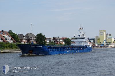
WILSON DURNESS
General Cargo
Current Trip
NOMJF
| Time Travelled | 19 h, 48 mins |
|---|---|
| Remaining Time | --- |
| Distance Travelled | 108.43 nm |
| Remaining Distance | --- |
| AVG Speed | 8.8 Knots |
| MAX Speed | 10.7 Knots |
| AVG Wind | 9.6 knots |
| MAX Wind | 14 knots |
| MIN Temp | 13.3°C / 55.94°F |
| MAX Temp | 15.7°C / 60.26°F |
| Draught | 5.9 m |
| Position Received | 8 h, 0 m ago |
Current Position
| Longitude | 4.73902° |
|---|---|
| Latitude | 53.46845° |
| Status | Under way using engine |
| Speed | 9.6 Knots |
| Course | 19° |
| Area | North Sea |
| Station | T-AIS |
| Position Received | 8 h, 0 m ago |
Info
Information
The current position of WILSON DURNESS is in North Sea with coordinates 53.46845° / 4.73902° as reported on 2024-05-30 06:37 by AIS to our vessel tracker app. The vessel's current speed is 9.6 Knots
The vessel WILSON DURNESS (IMO: 9390135, MMSI: 314632000) is a General Cargo that was built in 2008 ( 16 years old ). It's sailing under the flag of [BB] Barbados.
In this page you can find informations about the vessels current position, last detected port calls, and current voyage information. If the vessels is not in coverage by AIS you will find the latest position.
The current position of WILSON DURNESS is detected by our AIS receivers and we are not responsible for the reliability of the data. The last position was recorded while the vessel was in Coverage by the Ais receivers of our vessel tracking app.
The current draught of WILSON DURNESS as reported by AIS is 5.9 meters
Weather
| Temperature | 13.8°C / 56.84°F |
|---|---|
| Wind Speed | 12 knots |
| Direction | 212° SSW |
| Pressure | 1004.3 hPa |
| Humidity | 89.9 % |
| Cloud Coverage | --- |
Featured Company
Last Port Calls
| Port | Arrival | Departure | Time In Port |
|---|---|---|---|
| 2024-05-27 20:32 | 2024-05-29 18:49 | 1 d | |
| 2024-05-26 00:52 | 2024-05-27 17:57 | 1 d | |
| 2024-05-18 05:41 | 2024-05-23 14:11 | 5 d | |
| 2024-05-12 00:20 | 2024-05-14 18:38 | 2 d | |
| 2024-05-06 19:05 | 2024-05-07 15:37 | 20 h | |
| 2024-04-24 05:46 | 2024-05-03 10:47 | 9 d | |
| 2024-04-18 05:08 | 2024-04-19 13:06 | 1 d | |
| 2024-04-15 17:29 | 2024-04-17 08:43 | 1 d | |
| 2024-04-10 12:16 | 2024-04-12 01:33 | 1 d | |
| 2024-04-04 04:23 | 2024-04-05 20:16 | 1 d |
Last Trips
| Origin | Departure | Destination | Arrival | Distance | |
|---|---|---|---|---|---|
| 2024-05-27 19:57 | 2024-05-27 22:32 | 21.66 nm | |||
| 2024-05-23 16:11 | 2024-05-26 02:52 | 546.65 nm | |||
| 2024-05-14 20:38 | 2024-05-18 07:41 | 563.55 nm | |||
| 2024-05-07 17:37 | 2024-05-12 02:20 | 1010.14 nm | |||
| 2024-05-03 12:47 | 2024-05-06 21:05 | 368.66 nm | |||
| 2024-04-19 15:06 | 2024-04-24 07:46 | 985.78 nm | |||
| 2024-04-17 10:43 | 2024-04-18 07:08 | 190.72 nm | |||
| 2024-04-12 03:33 | 2024-04-15 19:29 | 862.30 nm | |||
| 2024-04-05 22:16 | 2024-04-10 14:16 | 864.71 nm | |||
| 2024-04-02 22:47 | 2024-04-04 06:23 | 313.69 nm |
Events
| Time | Event | Details | Position / Dest | Info |
|---|---|---|---|---|
| 2024-05-30 06:54 | Status Changed | Default Under way using engine |
53.51236 / 4.76401
NOMJF
|
Speed: 9.6 kn Course: 19° |
| 2024-05-30 06:37 | OUT of Coverage |
53.46845 / 4.73902
North Sea
|
Speed: 9.6 kn Course: 19° |
|
| 2024-05-30 06:04 | Status Changed | Under way using engine Default |
53.38701 / 4.68922
NOMJF
|
Speed: 9.2 kn Course: 18° |
| 2024-05-30 05:53 | Status Changed | Default Under way using engine |
53.36035 / 4.67330
NOMJF
|
Speed: 9.2 kn Course: 18.6° |
| 2024-05-30 05:51 | Status Changed | Under way using engine Default |
53.35430 / 4.66992
NOMJF
|
Speed: 9.3 kn Course: 21° |
| 2024-05-30 05:35 | IN Coverage |
53.35430 / 4.66992
North Sea
|
Speed: 9.2 kn Course: 18.6° |
|
| 2024-05-30 03:50 | Status Changed | Default Under way using engine |
53.07990 / 4.44402
NOMJF
|
Speed: 8.5 kn Course: 32.7° |
| 2024-05-30 03:40 | OUT of Coverage |
53.05962 / 4.42203
North Sea
|
Speed: 8.5 kn Course: 32.7° |
|
| 2024-05-30 02:37 | Status Changed | Under way using engine Default |
52.92067 / 4.30201
NOMJF
|
Speed: 8.9 kn Course: 19° |
| 2024-05-30 02:18 | Status Changed | Default Under way using engine |
52.87683 / 4.27567
NOMJF
|
Speed: 9 kn Course: 20.2° |