
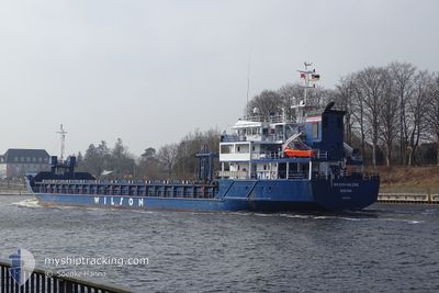
WILSON HALSVIK
General Cargo
Current Trip
| Time Travelled | 1 day |
|---|---|
| Remaining Time | --- |
| Distance Travelled | 62.28 nm |
| Remaining Distance | --- |
| AVG Speed | 8.9 Knots |
| MAX Speed | 11.5 Knots |
| AVG Wind | 5.5 knots |
| MAX Wind | 9.8 knots |
| MIN Temp | 12.6°C / 54.68°F |
| MAX Temp | 17.2°C / 62.96°F |
| Draught | 3.8 m |
| Position Received | 1 h, 34 m ago |
Current Position
| Longitude | 3.68970° |
|---|---|
| Latitude | 52.14526° |
| Status | At anchor |
| Speed | 0.1 Knots |
| Course | 39° |
| Area | North Sea |
| Station | T-AIS |
| Position Received | 1 h, 34 m ago |
Info
Information
The current position of WILSON HALSVIK is in North Sea with coordinates 52.14526° / 3.68970° as reported on 2024-05-17 03:49 by AIS to our vessel tracker app. The vessel's current speed is 0.1 Knots
The vessel WILSON HALSVIK (IMO: 9017422, MMSI: 314630000) is a General Cargo that was built in 2001 ( 23 years old ). It's sailing under the flag of [BB] Barbados.
In this page you can find informations about the vessels current position, last detected port calls, and current voyage information. If the vessels is not in coverage by AIS you will find the latest position.
The current position of WILSON HALSVIK is detected by our AIS receivers and we are not responsible for the reliability of the data. The last position was recorded while the vessel was in Coverage by the Ais receivers of our vessel tracking app.
The current draught of WILSON HALSVIK as reported by AIS is 3.8 meters
Weather
| Temperature | 13.1°C / 55.58°F |
|---|---|
| Wind Speed | 7 knots |
| Direction | 316° NW |
| Pressure | 1008 hPa |
| Humidity | 86.9 % |
| Cloud Coverage | 79 % |
Featured Company
Last Port Calls
| Port | Arrival | Departure | Time In Port |
|---|---|---|---|
| 2024-05-14 11:07 | 2024-05-15 14:05 | 1 d | |
| 2024-05-11 12:36 | 2024-05-12 18:55 | 1 d | |
| 2024-05-09 01:24 | 2024-05-09 02:39 | 1 h | |
| 2024-05-06 08:35 | 2024-05-08 21:34 | 2 d | |
| 2024-04-20 03:26 | 2024-04-22 21:13 | 2 d | |
| 2024-04-15 22:30 | 2024-04-18 18:17 | 2 d | |
| 2024-04-10 04:00 | 2024-04-11 18:22 | 1 d | |
| 2024-03-28 09:49 | 2024-04-08 16:22 | 11 d | |
| 2024-03-23 04:01 | 2024-03-27 05:50 | 4 d | |
| 2024-03-22 12:16 | 2024-03-23 03:47 | 15 h |
Last Trips
| Origin | Departure | Destination | Arrival | Distance | |
|---|---|---|---|---|---|
| 2024-05-12 19:55 | 2024-05-14 13:07 | 391.46 nm | |||
| 2024-05-08 22:34 | 2024-05-11 13:36 | 679.34 nm | |||
| 2024-05-08 22:34 | 2024-05-09 02:24 | 31.31 nm | |||
| 2024-04-22 23:13 | 2024-05-06 09:35 | 1608.78 nm | |||
| 2024-04-18 19:17 | 2024-04-20 05:26 | 345.23 nm | |||
| 2024-04-11 21:22 | 2024-04-15 23:30 | 803.35 nm | |||
| 2024-04-08 18:22 | 2024-04-10 07:00 | 334.32 nm | |||
| 2024-03-27 06:50 | 2024-03-28 10:49 | 231.20 nm | |||
| 2024-03-23 04:47 | 2024-03-23 05:01 | 0.63 nm | |||
| 2024-03-12 23:34 | 2024-03-22 13:16 | 1301.06 nm |
Events
| Time | Event | Details | Position / Dest | Info |
|---|---|---|---|---|
| 2024-05-17 03:55 | Status Changed | Default At anchor |
52.14530 / 3.68973
NLRTM
|
Speed: 0.1 kn Course: 39° |
| 2024-05-17 03:49 | Status Changed | At anchor Default |
52.14526 / 3.68970
NLRTM
|
Speed: 0.1 kn Course: 35° |
| 2024-05-17 03:49 | IN Coverage |
52.14526 / 3.68970
North Sea
|
Speed: 0.1 kn Course: 130.8° |
|
| 2024-05-17 03:49 | OUT of Coverage |
52.14526 / 3.68970
North Sea
|
Speed: 0.1 kn Course: 130.8° |
|
| 2024-05-17 01:16 | Status Changed | Default At anchor |
52.14521 / 3.69090
NLRTM
|
Speed: 0.2 kn Course: 335° |
| 2024-05-17 01:13 | OUT of Coverage |
52.14530 / 3.69113
North Sea
|
Speed: 0.2 kn Course: 192.7° |
|
| 2024-05-17 00:34 | Status Changed | At anchor Default |
52.14646 / 3.69132
NLRTM
|
Speed: Course: 225° |
| 2024-05-17 00:25 | Status Changed | Default At anchor |
52.14653 / 3.69128
NLRTM
|
Speed: Course: 227° |
| 2024-05-16 23:34 | Status Changed | At anchor Default |
52.14660 / 3.69127
NLRTM
|
Speed: Course: 197° |
| 2024-05-16 23:34 | IN Coverage |
52.14660 / 3.69127
North Sea
|
Speed: 0.2 kn Course: 104.9° |