
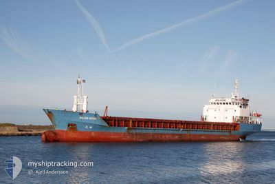
WILSON HUSUM
Limestone Carrier
Current Trip
| Time Travelled | 11 days |
|---|---|
| Remaining Time | --- |
| Distance Travelled | 2005.66 nm |
| Remaining Distance | --- |
| AVG Speed | 8.2 Knots |
| MAX Speed | 12.5 Knots |
| AVG Wind | 19 knots |
| MAX Wind | 34 knots |
| MIN Temp | 4.4°C / 39.92°F |
| MAX Temp | 16.5°C / 61.7°F |
| Draught | 3.6 m |
| Position Received | 2 m ago |
Current Position
| Longitude | 6.53851° |
|---|---|
| Latitude | 60.08515° |
| Status | Moored |
| Speed | |
| Course | 308° |
| Area | North Sea |
| Station | T-AIS |
| Position Received | 2 m ago |
Info
Information
The current position of WILSON HUSUM is in North Sea with coordinates 60.08515° / 6.53851° as reported on 2024-06-18 13:29 by AIS to our vessel tracker app. The vessel's current speed is 0 Knots
The vessel WILSON HUSUM (IMO: 9017379, MMSI: 314208000) is a Limestone Carrier that was built in 1998 ( 26 years old ). It's sailing under the flag of [BB] Barbados.
In this page you can find informations about the vessels current position, last detected port calls, and current voyage information. If the vessels is not in coverage by AIS you will find the latest position.
The current position of WILSON HUSUM is detected by our AIS receivers and we are not responsible for the reliability of the data. The last position was recorded while the vessel was in Coverage by the Ais receivers of our vessel tracking app.
The current draught of WILSON HUSUM as reported by AIS is 3.6 meters
Weather
| Temperature | 7.2°C / 44.96°F |
|---|---|
| Wind Speed | 5 knots |
| Direction | 269° W |
| Pressure | 1008 hPa |
| Humidity | 81.1 % |
| Cloud Coverage | 100 % |
Featured Company
Last Port Calls
| Port | Arrival | Departure | Time In Port |
|---|---|---|---|
| 2024-06-06 10:18 | 2024-06-07 09:00 | 22 h | |
| 2024-06-04 15:43 | 2024-06-06 01:03 | 1 d | |
| 2024-06-02 19:28 | 2024-06-03 17:51 | 22 h | |
| 2024-05-28 05:20 | 2024-05-29 22:28 | 1 d | |
| 2024-05-03 04:13 | 2024-05-03 21:28 | 17 h | |
| 2024-04-26 09:48 | 2024-04-28 06:23 | 1 d | |
| 2024-04-22 17:58 | 2024-04-24 20:52 | 2 d | |
| 2024-04-18 05:52 | 2024-04-22 13:49 | 4 d | |
| 2024-04-06 10:08 | 2024-04-08 15:32 | 2 d | |
| 2024-04-03 17:08 | 2024-04-05 16:38 | 1 d |
Last Trips
| Origin | Departure | Destination | Arrival | Distance | |
|---|---|---|---|---|---|
| 2024-06-06 03:03 | 2024-06-06 12:18 | 93.98 nm | |||
| 2024-06-03 18:51 | 2024-06-04 17:43 | 213.99 nm | |||
| 2024-05-29 23:28 | 2024-06-02 20:28 | 693.19 nm | |||
| 2024-05-03 23:28 | 2024-05-28 06:20 | 3168.63 nm | |||
| 2024-04-28 06:23 | 2024-05-03 06:13 | 1027.40 nm | |||
| 2024-04-24 20:52 | 2024-04-26 09:48 | 364.14 nm | |||
| 2024-04-22 13:49 | 2024-04-22 17:58 | 21.93 nm | |||
| 2024-04-08 17:32 | 2024-04-18 05:52 | 1424.41 nm | |||
| 2024-04-05 18:38 | 2024-04-06 12:08 | 118.92 nm | |||
| 2024-03-25 19:36 | 2024-04-03 19:08 | 1625.19 nm |
Events
| Time | Event | Details | Position / Dest | Info |
|---|---|---|---|---|
| 2024-06-18 12:59 | Status Changed | Moored Default |
60.08515 / 6.53852
NOODD
|
Speed: Course: 307° |
| 2024-06-18 12:56 | Status Changed | Default Moored |
60.08515 / 6.53852
NOODD
|
Speed: Course: 307° |
| 2024-06-18 12:50 | Status Changed | Moored Default |
60.08515 / 6.53852
NOODD
|
Speed: Course: 307° |
| 2024-06-18 12:44 | Status Changed | Default Moored |
60.08515 / 6.53853
NOODD
|
Speed: Course: 307° |
| 2024-06-18 11:23 | Status Changed | Moored Default |
60.08516 / 6.53854
NOODD
|
Speed: Course: 306° |
| 2024-06-18 11:20 | Status Changed | Default Moored |
60.08516 / 6.53853
NOODD
|
Speed: Course: 306° |
| 2024-06-17 18:23 | Status Changed | Moored Under way using engine |
60.08533 / 6.53812
NOODD
|
Speed: Course: 305° |
| 2024-06-17 18:15 | STOP Moving | 0.82 nm, North of ODDA |
60.08513 / 6.53844
NOODD
|
Speed: 0.3 kn Course: 304° |
| 2024-06-17 13:47 | IN Coverage |
60.17769 / 6.07834
North Sea
NOODD
|
Speed: 11 kn Course: 353.2° |
|
| 2024-06-17 12:46 | OUT of Coverage |
60.01726 / 5.93181
North Sea
NOODD
|
Speed: 10.6 kn Course: 47.1° |