
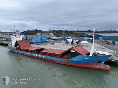
WILSON MONSOON
General Cargo
Current Trip
| Time Travelled | 2 days |
|---|---|
| Remaining Time | 11 h, 55 mins |
| Distance Travelled | 708.33 nm |
| Remaining Distance | 111.79 nm |
| AVG Speed | 10.8 Knots |
| MAX Speed | 15.2 Knots |
| AVG Wind | 9 knots |
| MAX Wind | 17.9 knots |
| MIN Temp | 11.3°C / 52.34°F |
| MAX Temp | 16.8°C / 62.24°F |
| Draught | 4.3 m |
| Position Received | 1 m ago |
Current Position
| Longitude | 9.34354° |
|---|---|
| Latitude | 57.49040° |
| Status | Under way using engine |
| Speed | 9.1 Knots |
| Course | 57.8° |
| Area | Skaggerak |
| Station | T-AIS |
| Position Received | 1 m ago |
Info
Information
The current position of WILSON MONSOON is in Skaggerak with coordinates 57.49040° / 9.34354° as reported on 2024-05-18 04:40 by AIS to our vessel tracker app. The vessel's current speed is 9.1 Knots and is heading at the port of UDDEVALLA. The estimated time of arrival as calculated by vessel tracking app is 2024-05-18 16:36 LT
The vessel WILSON MONSOON (IMO: 9163582, MMSI: 314475000) is a General Cargo that was built in 1997 ( 27 years old ). It's sailing under the flag of [BB] Barbados.
In this page you can find informations about the vessels current position, last detected port calls, and current voyage information. If the vessels is not in coverage by AIS you will find the latest position.
The current position of WILSON MONSOON is detected by our AIS receivers and we are not responsible for the reliability of the data. The last position was recorded while the vessel was in Coverage by the Ais receivers of our vessel tracking app.
The current draught of WILSON MONSOON as reported by AIS is 4.3 meters
Weather
| Temperature | 11.6°C / 52.88°F |
|---|---|
| Wind Speed | 8 knots |
| Direction | 87° E |
| Pressure | 1016.7 hPa |
| Humidity | 75.4 % |
| Cloud Coverage | 33 % |
Featured Company
Last Port Calls
| Port | Arrival | Departure | Time In Port |
|---|---|---|---|
| 2024-05-13 16:11 | 2024-05-15 14:55 | 1 d | |
| 2024-05-02 18:56 | 2024-05-03 22:16 | 1 d | |
| 2024-04-29 23:46 | 2024-05-02 17:21 | 2 d | |
| 2024-04-19 16:26 | 2024-04-22 17:30 | 3 d | |
| 2024-04-13 18:06 | 2024-04-17 05:33 | 3 d | |
| 2024-04-12 07:44 | 2024-04-12 19:46 | 12 h | |
| 2024-04-09 18:47 | 2024-04-09 19:42 | 54 m | |
| 2024-04-07 23:50 | 2024-04-08 19:05 | 19 h | |
| 2024-04-06 02:19 | 2024-04-06 02:24 | 4 m | |
| 2024-04-04 04:15 | 2024-04-05 06:17 | 1 d |
Last Trips
| Origin | Departure | Destination | Arrival | Distance | |
|---|---|---|---|---|---|
| 2024-05-04 00:16 | 2024-05-13 18:11 | 1528.18 nm | |||
| 2024-05-02 19:21 | 2024-05-02 20:56 | 16.40 nm | |||
| 2024-04-22 18:30 | 2024-04-30 01:46 | 593.68 nm | |||
| 2024-04-17 07:33 | 2024-04-19 17:26 | 545.85 nm | |||
| 2024-04-12 20:46 | 2024-04-13 20:06 | 227.92 nm | |||
| 2024-04-09 21:42 | 2024-04-12 08:44 | 415.17 nm | |||
| 2024-04-08 21:05 | 2024-04-09 20:47 | 242.76 nm | |||
| 2024-04-06 04:24 | 2024-04-08 01:50 | 245.25 nm | |||
| 2024-04-05 08:17 | 2024-04-06 04:19 | 138.80 nm | |||
| 2024-03-29 14:10 | 2024-04-04 06:15 | 676.67 nm |
Events
| Time | Event | Details | Position / Dest | Info |
|---|---|---|---|---|
| 2024-05-18 01:01 | Change Sea Area | Danish part of the Skaggerak Danish part of the North Sea |
57.19102 / 8.49622
Skaggerak
SEUDD
|
Speed: 9.1 kn Course: 37.1° |
| 2024-05-17 13:14 | Change Sea Area | Danish part of the North Sea German part of the North Sea |
55.27274 / 7.00835
North Sea
SEUDD
|
Speed: 11.3 kn Course: 11.4° |
| 2024-05-17 12:20 | Change Sea Area | German part of the North Sea Dutch part of the North Sea |
55.10355 / 6.96139
North Sea
SEUDD
|
Speed: 11.4 kn Course: 4.3° |
| 2024-05-17 12:20 | Status Changed | Under way using engine Default |
55.10355 / 6.96139
SEUDD
|
Speed: 11 kn Course: 4° |
| 2024-05-17 12:14 | IN Coverage |
55.10355 / 6.96139
North Sea
SEUDD
|
Speed: 11.4 kn Course: 4.3° |
|
| 2024-05-16 23:57 | Status Changed | Default Under way using engine |
53.48941 / 4.73559
SEUDD
|
Speed: 12.1 kn Course: 23.4° |
| 2024-05-16 23:55 | OUT of Coverage |
53.48270 / 4.73060
North Sea
SEUDD
|
Speed: 12.1 kn Course: 23.4° |
|
| 2024-05-16 22:39 | Status Changed | Under way using engine Default |
53.23795 / 4.55267
SEUDD
|
Speed: 12.8 kn Course: 29° |
| 2024-05-16 21:47 | Status Changed | Default Under way using engine |
53.07167 / 4.40833
SEUDD
|
Speed: 12.7 kn Course: 26.8° |
| 2024-05-16 21:26 | Status Changed | Under way using engine Default |
53.00734 / 4.35485
SEUDD
|
Speed: 12.2 kn Course: 27° |