
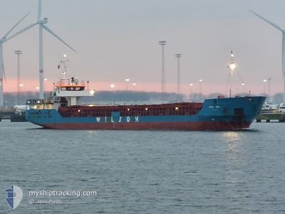
WILSON ODRA
General Cargo
Current Trip
| Time Travelled | 5 days |
|---|---|
| Remaining Time | 2 days |
| Distance Travelled | 369.18 nm |
| Remaining Distance | 662.93 nm |
| AVG Speed | 9.7 Knots |
| MAX Speed | 11.7 Knots |
| AVG Wind | 9.6 knots |
| MAX Wind | 30.4 knots |
| MIN Temp | 6.8°C / 44.24°F |
| MAX Temp | 15.6°C / 60.08°F |
| Draught | 3.6 m |
| Position Received | 1 d ago |
Current Position
| Longitude | -5.13117° |
|---|---|
| Latitude | 50.81417° |
| Status | Under way using engine |
| Speed | 11 Knots |
| Course | 233° |
| Area | Celtic Sea |
| Station | T-AIS |
| Position Received | 1 d ago |
Info
Information
The current position of WILSON ODRA is in Celtic Sea with coordinates 50.81417° / -5.13117° as reported on 2024-06-17 16:30 by AIS to our vessel tracker app. The vessel's current speed is 11 Knots and is heading at the port of SETUBAL. The estimated time of arrival as calculated by vessel tracking app is 2024-06-20 22:59 LT
The vessel WILSON ODRA (IMO: 9177882, MMSI: 314584000) is a General Cargo that was built in 1999 ( 25 years old ). It's sailing under the flag of [BB] Barbados.
In this page you can find informations about the vessels current position, last detected port calls, and current voyage information. If the vessels is not in coverage by AIS you will find the latest position.
The current position of WILSON ODRA is detected by our AIS receivers and we are not responsible for the reliability of the data. The last position was recorded while the vessel was in Coverage by the Ais receivers of our vessel tracking app.
The current draught of WILSON ODRA as reported by AIS is 3.6 meters
Weather
| Temperature | 15.5°C / 59.9°F |
|---|---|
| Wind Speed | 18 knots |
| Direction | 29° NNE |
| Pressure | 1015 hPa |
| Humidity | 89.1 % |
| Cloud Coverage | 77 % |
Featured Company
Last Port Calls
| Port | Arrival | Departure | Time In Port |
|---|---|---|---|
| 2024-06-11 22:25 | 2024-06-12 21:47 | 23 h | |
| 2024-06-06 20:56 | 2024-06-07 08:55 | 11 h | |
| 2024-05-23 06:33 | 2024-05-23 17:17 | 10 h | |
| 2024-05-17 14:13 | 2024-05-21 13:51 | 3 d | |
| 2024-05-17 01:19 | 2024-05-17 13:33 | 12 h | |
| 2024-05-10 00:00 | 2024-05-11 08:43 | 1 d | |
| 2024-05-03 20:44 | 2024-05-08 18:01 | 4 d | |
| 2024-04-26 04:24 | 2024-04-26 16:37 | 12 h | |
| 2024-04-23 09:32 | 2024-04-25 11:40 | 2 d | |
| 2024-04-22 19:57 | 2024-04-22 20:34 | 36 m |
Last Trips
| Origin | Departure | Destination | Arrival | Distance | |
|---|---|---|---|---|---|
| 2024-06-07 10:55 | 2024-06-11 23:25 | 986.66 nm | |||
| 2024-05-23 19:17 | 2024-06-06 22:56 | 1236.50 nm | |||
| 2024-05-21 15:51 | 2024-05-23 08:33 | 374.44 nm | |||
| 2024-05-17 15:33 | 2024-05-17 16:13 | 6.84 nm | |||
| 2024-05-11 10:43 | 2024-05-17 03:19 | 264.24 nm | |||
| 2024-05-08 20:01 | 2024-05-10 02:00 | 291.43 nm | |||
| 2024-04-26 17:37 | 2024-05-03 22:44 | 751.85 nm | |||
| 2024-04-25 12:40 | 2024-04-26 05:24 | 126.75 nm | |||
| 2024-04-22 21:34 | 2024-04-23 10:32 | 134.01 nm | |||
| 2024-04-22 20:40 | 2024-04-22 20:57 | 2.01 nm |
Events
| Time | Event | Details | Position / Dest | Info |
|---|---|---|---|---|
| 2024-06-17 16:35 | Status Changed | Default Under way using engine |
50.80334 / -5.15283
PT SET
|
Speed: 11 kn Course: 233° |
| 2024-06-17 16:30 | OUT of Coverage |
50.81417 / -5.13117
Celtic Sea
PT SET
|
Speed: 11 kn Course: 233° |
|
| 2024-06-17 16:16 | Status Changed | Under way using engine Default |
50.84084 / -5.07883
PT SET
|
Speed: 11.2 kn Course: 229° |
| 2024-06-17 16:15 | Status Changed | Default Under way using engine |
50.84167 / -5.07700
PT SET
|
Speed: 10.8 kn Course: 230° |
| 2024-06-17 14:01 | Change Sea Area | United Kingdom part of the Celtic Sea United Kingdom part of the Bristol Channel |
51.08950 / -4.60083
Celtic Sea
PT SET
|
Speed: 9.6 kn Course: 230° |
| 2024-06-17 13:34 | Draught Changed | 3.6 0 |
51.13233 / -4.51433
PT SET
|
Speed: 9.2 kn Course: 231° |
| 2024-06-17 13:34 | Destination Changed | PT SET GB CDF |
51.13233 / -4.51433
PT SET
|
Speed: 9.2 kn Course: 231° |
| 2024-06-17 13:34 | ETA Changed | 2024/06/21 08:00 |
51.13233 / -4.51433
PT SET
|
Speed: 9.2 kn Course: 231° |
| 2024-06-17 13:16 | Status Changed | Under way using engine Default |
51.16183 / -4.45717
GB CDF
|
Speed: 9.5 kn Course: 231° |
| 2024-06-17 13:16 | IN Coverage |
51.16069 / -4.45921
Bristol Channel
|
Speed: 9.2 kn Course: 230° |