
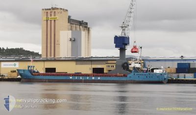
WILSON WAAL
General Cargo
Current Trip
| Time Travelled | 2 days |
|---|---|
| Remaining Time | 3 h, 21 mins |
| Distance Travelled | 508.51 nm |
| Remaining Distance | 32.92 nm |
| AVG Speed | 9.2 Knots |
| MAX Speed | 10.7 Knots |
| AVG Wind | 7.4 knots |
| MAX Wind | 18 knots |
| MIN Temp | 9.9°C / 49.82°F |
| MAX Temp | 18.1°C / 64.58°F |
| Draught | 3.4 m |
| Position Received | 1 m ago |
Current Position
| Longitude | 4.84513° |
|---|---|
| Latitude | 59.83023° |
| Status | Under way using engine |
| Speed | 8.5 Knots |
| Course | 166.2° |
| Area | North Sea |
| Station | T-AIS |
| Position Received | 1 m ago |
Info
Information
The current position of WILSON WAAL is in North Sea with coordinates 59.83023° / 4.84513° as reported on 2024-05-18 20:07 by AIS to our vessel tracker app. The vessel's current speed is 8.5 Knots and is heading at the port of STORASUND. The estimated time of arrival as calculated by vessel tracking app is 2024-05-18 23:30 LT
The vessel WILSON WAAL (IMO: 9178446, MMSI: 314262000) is a General Cargo that was built in 1999 ( 25 years old ). It's sailing under the flag of [BB] Barbados.
In this page you can find informations about the vessels current position, last detected port calls, and current voyage information. If the vessels is not in coverage by AIS you will find the latest position.
The current position of WILSON WAAL is detected by our AIS receivers and we are not responsible for the reliability of the data. The last position was recorded while the vessel was in Coverage by the Ais receivers of our vessel tracking app.
The current draught of WILSON WAAL as reported by AIS is 3.4 meters
Weather
| Temperature | 11.2°C / 52.16°F |
|---|---|
| Wind Speed | 5 knots |
| Direction | 319° NW |
| Pressure | 1016.2 hPa |
| Humidity | 84.5 % |
| Cloud Coverage | 64 % |
Featured Company
Last Port Calls
| Port | Arrival | Departure | Time In Port |
|---|---|---|---|
| 2024-05-15 04:03 | 2024-05-16 12:42 | 1 d | |
| 2024-05-11 14:04 | 2024-05-13 15:41 | 2 d | |
| 2024-05-05 16:51 | 2024-05-07 17:48 | 2 d | |
| 2024-05-05 03:07 | 2024-05-05 12:13 | 9 h | |
| 2024-04-29 09:52 | 2024-05-01 04:11 | 1 d | |
| 2024-04-23 18:04 | 2024-04-24 18:31 | 1 d | |
| 2024-04-23 16:21 | 2024-04-23 16:25 | 3 m | |
| 2024-04-23 08:38 | 2024-04-23 14:39 | 6 h | |
| 2024-04-17 21:18 | 2024-04-18 11:13 | 13 h | |
| 2024-04-15 12:30 | 2024-04-15 19:39 | 7 h |
Last Trips
| Origin | Departure | Destination | Arrival | Distance | |
|---|---|---|---|---|---|
| 2024-05-13 17:41 | 2024-05-15 06:03 | 30.48 nm | |||
| 2024-05-07 19:48 | 2024-05-11 16:04 | 848.11 nm | |||
| 2024-05-05 14:13 | 2024-05-05 18:51 | 41.97 nm | |||
| 2024-05-01 06:11 | 2024-05-05 05:07 | 838.28 nm | |||
| 2024-04-24 20:31 | 2024-04-29 11:52 | 1026.72 nm | |||
| 2024-04-23 18:25 | 2024-04-23 20:04 | 2.16 nm | |||
| 2024-04-23 16:39 | 2024-04-23 18:21 | 11.34 nm | |||
| 2024-04-18 13:13 | 2024-04-23 10:38 | 353.72 nm | |||
| 2024-04-15 21:39 | 2024-04-17 23:18 | 452.87 nm | |||
| 2024-04-02 16:24 | 2024-04-15 14:30 | 1145.58 nm |
Events
| Time | Event | Details | Position / Dest | Info |
|---|---|---|---|---|
| 2024-05-18 11:52 | Change Sea Area | Norwegian part of the North Sea Norwegian part of the Norwegian Sea |
60.99445 / 4.26064
North Sea
NOSRS
|
Speed: 8.5 kn Course: 179.7° |
| 2024-05-18 07:54 | ETA Changed | 2024/05/18 23:00 2024/05/18 22:00 |
61.59677 / 4.40484
NOSRS
|
Speed: 8.9 kn Course: 186.3° |
| 2024-05-17 18:51 | ETA Changed | 2024/05/18 22:00 2024/05/18 20:00 |
63.27295 / 6.57814
NOSRS
|
Speed: 9.1 kn Course: 219° |
| 2024-05-17 08:23 | Destination Changed | NOSRS NLMOE |
64.54694 / 8.62371
NOSRS
|
Speed: 9.6 kn Course: 219.7° |
| 2024-05-17 08:23 | ETA Changed | 2024/05/18 20:00 2024/05/21 10:00 |
64.54694 / 8.62371
NOSRS
|
Speed: 9.6 kn Course: 219.7° |
| 2024-05-16 12:42 | PORT DEPARTURE |
|
66.30415 / 14.09079
NLMOE
|
Speed: 7 kn Course: 246° |
| 2024-05-16 12:38 | START Moving |
66.30769 / 14.10764
[NO] MOIRANA
|
Speed: 3.4 kn Course: 256° |
|
| 2024-05-16 12:32 | Status Changed | Under way using engine Moored |
66.30717 / 14.11045
[NO] MOIRANA
|
Speed: 0.1 kn Course: 89° |
| 2024-05-16 08:29 | Draught Changed | 3.4 4.2 |
66.30615 / 14.11395
[NO] MOIRANA
|
Speed: Course: 73° |
| 2024-05-16 08:29 | Destination Changed | NLMOE NOMQN |
66.30615 / 14.11395
[NO] MOIRANA
|
Speed: Course: 73° |