
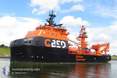
WIND CREATION
Cargo
Current Trip
| Time Travelled | 3 days |
|---|---|
| Remaining Time | --- |
| Distance Travelled | 383.40 nm |
| Remaining Distance | --- |
| AVG Speed | 10.9 Knots |
| MAX Speed | 15.2 Knots |
| AVG Wind | 8.3 knots |
| MAX Wind | 16 knots |
| MIN Temp | 12.2°C / 53.96°F |
| MAX Temp | 14.7°C / 58.46°F |
| Draught | 5.7 m |
| Position Received | 1 m ago |
Current Position
| Longitude | -2.10802° |
|---|---|
| Latitude | 48.71217° |
| Status | Restricted manoeuverability |
| Speed | |
| Course | 305° |
| Area | English Channel |
| Station | T-AIS |
| Position Received | 1 m ago |
Info
Information
The current position of WIND CREATION is in English Channel with coordinates 48.71217° / -2.10802° as reported on 2024-06-09 22:38 by AIS to our vessel tracker app. The vessel's current speed is 0 Knots
The vessel WIND CREATION (IMO: 9730517, MMSI: 232054785) is a Cargo It's sailing under the flag of [GB] United Kingdom.
In this page you can find informations about the vessels current position, last detected port calls, and current voyage information. If the vessels is not in coverage by AIS you will find the latest position.
The current position of WIND CREATION is detected by our AIS receivers and we are not responsible for the reliability of the data. The last position was recorded while the vessel was in Coverage by the Ais receivers of our vessel tracking app.
The current draught of WIND CREATION as reported by AIS is 5.7 meters
Weather
| Temperature | 14.2°C / 57.56°F |
|---|---|
| Wind Speed | 14 knots |
| Direction | 310° NW |
| Pressure | 1015.2 hPa |
| Humidity | 76.9 % |
| Cloud Coverage | 2 % |
Featured Company
Last Port Calls
| Port | Arrival | Departure | Time In Port |
|---|---|---|---|
| 2024-06-04 17:18 | 2024-06-06 18:22 | 2 d | |
| 2024-05-31 12:31 | 2024-06-02 22:19 | 2 d | |
| 2024-05-28 20:05 | 2024-05-28 22:04 | 1 h | |
| 2024-05-23 11:00 |
Most Visited Ports (Last year)
| Port | Arrivals | |
|---|---|---|
| 2 | ||
| 1 |
Last Trips
| Origin | Departure | Destination | Arrival | Distance | |
|---|---|---|---|---|---|
| 2024-06-03 00:19 | 2024-06-04 19:18 | 64.68 nm | |||
| 2024-05-29 00:04 | 2024-05-31 14:31 | 291.03 nm | |||
| 2024-05-23 13:00 | 2024-05-28 22:05 | 220.33 nm |
Events
| Time | Event | Details | Position / Dest | Info |
|---|---|---|---|---|
| 2024-06-08 18:38 | IN Coverage |
48.71240 / -2.10782
English Channel
|
Speed: Course: 79° |
|
| 2024-06-08 17:38 | IN Coverage |
48.71245 / -2.10782
English Channel
|
Speed: Course: 79° |
|
| 2024-06-08 17:38 | OUT of Coverage |
48.71245 / -2.10782
English Channel
|
Speed: Course: 79° |
|
| 2024-06-08 16:27 | OUT of Coverage |
48.71244 / -2.10782
English Channel
|
Speed: Course: 79° |
|
| 2024-06-08 09:00 | IN Coverage |
48.71243 / -2.10780
English Channel
FRSML
|
Speed: Course: 103.5° |
|
| 2024-06-08 07:38 | OUT of Coverage |
48.71242 / -2.10781
English Channel
FRSML
|
Speed: Course: 103.5° |
|
| 2024-06-08 06:09 | Status Changed | Restricted manoeuverability Under way using engine |
48.71242 / -2.10783
FRSML
|
Speed: Course: 92° |
| 2024-06-08 05:13 | STOP Moving | 5.26 nm, North West of SAINT MALO |
48.71238 / -2.10781
FRSML
|
Speed: 0.2 kn Course: 112° |
| 2024-06-08 04:13 | Detected in Sea | French part of the English Channel |
48.79518 / -2.29049
English Channel
FRSML
|
Speed: 9.3 kn Course: 141° |
| 2024-06-08 00:50 | Change Sea Area | Jersey part of the English Channel Guernsey part of the English Channel |
49.32255 / -2.31372
English Channel
FRSML
|
Speed: 14 kn Course: 200.8° |