
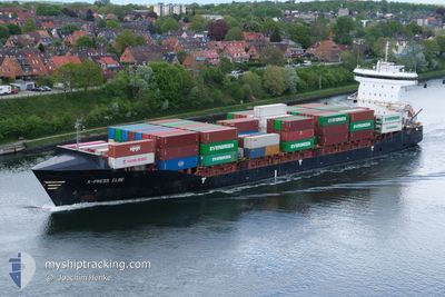
X-PRESS ELBE
Container Ship
Current Trip
| Time Travelled | 2 days |
|---|---|
| Remaining Time | 20 h, 6 mins |
| Distance Travelled | 528.12 nm |
| Remaining Distance | 266.68 nm |
| AVG Speed | 10.1 Knots |
| MAX Speed | 16.4 Knots |
| AVG Wind | 16.2 knots |
| MAX Wind | 24 knots |
| MIN Temp | 13°C / 55.4°F |
| MAX Temp | 19.8°C / 67.64°F |
| Draught | 8.6 m |
| Position Received | Now |
Current Position
| Longitude | 13.60949° |
|---|---|
| Latitude | 54.91895° |
| Status | Under way using engine |
| Speed | 13.1 Knots |
| Course | 69.5° |
| Area | Baltic Sea |
| Station | T-AIS |
| Position Received | Now |
Info
Information
The current position of X-PRESS ELBE is in Baltic Sea with coordinates 54.91895° / 13.60949° as reported on 2024-06-03 04:28 by AIS to our vessel tracker app. The vessel's current speed is 13.1 Knots and is heading at the port of KLAIPEDA. The estimated time of arrival as calculated by vessel tracking app is 2024-06-04 00:34 LT
The vessel X-PRESS ELBE (IMO: 9483669, MMSI: 212018000) is a Container Ship that was built in 2010 ( 14 years old ). It's sailing under the flag of [CY] Cyprus.
In this page you can find informations about the vessels current position, last detected port calls, and current voyage information. If the vessels is not in coverage by AIS you will find the latest position.
The current position of X-PRESS ELBE is detected by our AIS receivers and we are not responsible for the reliability of the data. The last position was recorded while the vessel was in Coverage by the Ais receivers of our vessel tracking app.
The current draught of X-PRESS ELBE as reported by AIS is 8.6 meters
Weather
| Temperature | 13.5°C / 56.3°F |
|---|---|
| Wind Speed | 16 knots |
| Direction | 287° WNW |
| Pressure | 1012.6 hPa |
| Humidity | 91.1 % |
| Cloud Coverage | 13 % |
Featured Company
Last Port Calls
| Port | Arrival | Departure | Time In Port |
|---|---|---|---|
| 2024-05-31 17:10 | 2024-06-01 02:40 | 9 h | |
| 2024-05-28 21:01 | 2024-05-31 06:33 | 2 d | |
| 2024-05-28 09:48 | 2024-05-28 19:34 | 9 h | |
| 2024-05-27 16:46 | 2024-05-28 08:07 | 15 h | |
| 2024-05-25 05:44 | 2024-05-27 15:10 | 2 d | |
| 2024-05-24 10:52 | 2024-05-25 04:03 | 17 h | |
| 2024-05-21 20:30 | 2024-05-21 21:25 | 55 m | |
| 2024-05-18 09:52 | 2024-05-18 23:48 | 13 h | |
| 2024-05-16 19:17 | 2024-05-17 11:32 | 16 h | |
| 2024-05-15 16:37 | 2024-05-15 16:40 | 2 m |
Most Visited Ports (Last year)
| Port | Arrivals | |
|---|---|---|
| 53 | ||
| 14 | ||
| 12 | ||
| 9 | ||
| 8 | ||
| 7 |
Last Trips
| Origin | Departure | Destination | Arrival | Distance | |
|---|---|---|---|---|---|
| 2024-05-31 08:33 | 2024-05-31 19:10 | 110.13 nm | |||
| 2024-05-28 21:34 | 2024-05-28 23:01 | 15.24 nm | |||
| 2024-05-28 10:07 | 2024-05-28 11:48 | 16.11 nm | |||
| 2024-05-27 17:10 | 2024-05-27 18:46 | 16.66 nm | |||
| 2024-05-25 06:03 | 2024-05-25 07:44 | 17.00 nm | |||
| 2024-05-21 23:25 | 2024-05-24 12:52 | 332.39 nm | |||
| 2024-05-19 02:48 | 2024-05-21 22:30 | 567.75 nm | |||
| 2024-05-17 14:32 | 2024-05-18 12:52 | 249.80 nm | |||
| 2024-05-15 18:40 | 2024-05-16 22:17 | 405.59 nm | |||
| 2024-05-14 06:12 | 2024-05-15 18:37 | 390.66 nm |
Events
| Time | Event | Details | Position / Dest | Info |
|---|---|---|---|---|
| 2024-06-03 03:57 | Status Changed | Under way using engine Default |
54.88051 / 13.42920
LTKLJ VIA NOK
|
Speed: 13.2 kn Course: 70° |
| 2024-06-03 03:54 | Status Changed | Default Under way using engine |
54.87703 / 13.41215
LTKLJ VIA NOK
|
Speed: 13.2 kn Course: 70.4° |
| 2024-06-03 03:27 | Status Changed | Under way using engine Default |
54.84339 / 13.24740
LTKLJ VIA NOK
|
Speed: 13 kn Course: 69° |
| 2024-06-03 03:22 | Status Changed | Default Under way using engine |
54.83764 / 13.22067
LTKLJ VIA NOK
|
Speed: 13 kn Course: 69.2° |
| 2024-06-02 23:43 | Change Sea Area | German part of the Baltic Sea Danish part of the Baltic Sea |
54.41017 / 12.12361
Baltic Sea
LTKLJ VIA NOK
|
Speed: 13.1 kn Course: 91.1° |
| 2024-06-02 21:43 | Change Sea Area | Danish part of the Baltic Sea German part of the Baltic Sea |
54.51588 / 11.41567
Baltic Sea
LTKLJ VIA NOK
|
Speed: 13.1 kn Course: 114.7° |
| 2024-06-02 19:58 | Detected in Sea | German part of the Baltic Sea |
54.56623 / 10.77907
Baltic Sea
LTKLJ VIA NOK
|
Speed: 13.1 kn Course: 86.3° |
| 2024-06-02 19:31 | Change Sea Area | Danish part of the Baltic Sea German part of the Baltic Sea |
54.55649 / 10.61083
Baltic Sea
LTKLJ VIA NOK
|
Speed: 13 kn Course: 81.4° |
| 2024-06-02 18:25 | Change Sea Area | German part of the Baltic Sea German part of the North Sea |
54.46343 / 10.26390
Baltic Sea
LTKLJ VIA NOK
|
Speed: 12.8 kn Course: 32.5° |
| 2024-06-02 17:42 | START Moving | 1.31 nm, South West of STICKENHΟRN SPORT |
54.36567 / 10.14492
LTKLJ VIA NOK
|
Speed: 3.1 kn Course: 101° |