
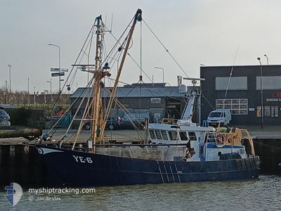
YE6 NOOR CATHARINA
Fishing
Current Trip
| Trip Time | 3 days |
|---|---|
| Trip Distance | 400.52 nm |
| AVG Speed | 4.7 Knots |
| MAX Speed | 9.9 Knots |
| Draught | 2.5 m |
| AVG Wind | 6.5 knots |
| MAX Wind | 12 knots |
| MIN Temp | 12.4°C / 54.32°F |
| MAX Temp | 19.4°C / 66.92°F |
| Position Received | 1 m ago |
Current Position
| Longitude | 3.58918° |
|---|---|
| Latitude | 51.44512° |
| Status | Engaged in Fishing |
| Speed | |
| Course | 11° |
| Area | North Sea |
| Station | T-AIS |
| Position Received | 1 m ago |
Info
Information
The current position of YE6 NOOR CATHARINA is in North Sea with coordinates 51.44512° / 3.58918° as reported on 2024-05-20 19:07 by AIS to our vessel tracker app. The vessel's current speed is 0 Knots and is currently inside the port of VLISSINGEN STATION.
The vessel YE6 NOOR CATHARINA (MMSI: 244615490) is a Fishing It's sailing under the flag of [NL] Netherlands.
In this page you can find informations about the vessels current position, last detected port calls, and current voyage information. If the vessels is not in coverage by AIS you will find the latest position.
The current position of YE6 NOOR CATHARINA is detected by our AIS receivers and we are not responsible for the reliability of the data. The last position was recorded while the vessel was in Coverage by the Ais receivers of our vessel tracking app.
The current draught of YE6 NOOR CATHARINA as reported by AIS is 2.5 meters
Weather
| Temperature | 13.4°C / 56.12°F |
|---|---|
| Wind Speed | 10 knots |
| Direction | 15° NNE |
| Pressure | 1009.8 hPa |
| Humidity | 93.4 % |
| Cloud Coverage | 97 % |
Featured Company
Last Port Calls
| Port | Arrival | Departure | Time In Port |
|---|---|---|---|
| 2024-05-16 11:56 | |||
| 2024-05-09 13:14 | 2024-05-12 22:23 | 3 d | |
| 2024-05-08 14:08 | 2024-05-08 15:11 | 1 h | |
| 2024-05-03 06:26 | 2024-05-05 22:47 | 2 d | |
| 2024-04-26 07:18 | 2024-04-28 22:19 | 2 d | |
| 2024-04-19 00:52 | 2024-04-21 22:40 | 2 d | |
| 2024-04-11 09:26 | 2024-04-16 18:19 | 5 d | |
| 2024-04-05 05:57 | 2024-04-07 23:01 | 2 d | |
| 2024-04-03 08:40 | 2024-04-03 12:18 | 3 h | |
| 2024-03-28 12:49 | 2024-04-01 18:04 | 4 d |
Most Visited Ports (Last year)
| Port | Arrivals | |
|---|---|---|
| 39 | ||
| 12 | ||
| 5 | ||
| 3 | ||
| 2 | ||
| 2 |
Last Trips
| Origin | Departure | Destination | Arrival | Distance | |
|---|---|---|---|---|---|
| 2024-05-13 00:23 | 2024-05-16 13:56 | 400.52 nm | |||
| 2024-05-08 17:11 | 2024-05-09 15:14 | 138.72 nm | |||
| 2024-05-06 00:47 | 2024-05-08 16:08 | 244.32 nm | |||
| 2024-04-29 00:19 | 2024-05-03 08:26 | 337.98 nm | |||
| 2024-04-22 00:40 | 2024-04-26 09:18 | 326.77 nm | |||
| 2024-04-16 20:19 | 2024-04-19 02:52 | 203.30 nm | |||
| 2024-04-08 01:01 | 2024-04-11 11:26 | 300.03 nm | |||
| 2024-04-03 14:18 | 2024-04-05 07:57 | 146.66 nm | |||
| 2024-04-01 20:04 | 2024-04-03 10:40 | 174.20 nm | |||
| 2024-03-27 03:50 | 2024-03-28 13:49 | 173.62 nm |
Events
| Time | Event | Details | Position / Dest | Info |
|---|---|---|---|---|
| 2024-05-16 12:07 | STOP Moving |
51.44482 / 3.59080
[NL] VLISSINGEN STATION
|
Speed: 0.3 kn Course: 186° |
|
| 2024-05-16 12:05 | START Moving |
51.44397 / 3.59237
[NL] VLISSINGEN STATION
|
Speed: 5.8 kn Course: 314° |
|
| 2024-05-16 11:56 | PORT ARRIVAL |
|
51.44308 / 3.59527
[NL] VLISSINGEN STATION
|
Speed: Course: 289° |
| 2024-05-16 11:56 | STOP Moving | 0.32 nm, South East of VLISSINGEN STATION |
51.44307 / 3.59525
FISHING *
|
Speed: Course: 289° |
| 2024-05-16 10:07 | Change Sea Area | Dutch part of the North Sea Belgian part of the North Sea |
51.40612 / 3.34062
North Sea
|
Speed: 7.5 kn Course: 40° |
| 2024-05-16 09:59 | START Moving | 5.37 nm, North East of ZEEBRUGGE |
51.39550 / 3.31877
FISHING *
|
Speed: 6.7 kn Course: 68° |
| 2024-05-16 09:57 | STOP Moving | 5.28 nm, North East of ZEEBRUGGE |
51.39552 / 3.31587
FISHING *
|
Speed: 0.3 kn Course: 100° |
| 2024-05-16 03:36 | START Moving | 5.67 nm, West of ZEEBRUGGE |
51.35568 / 3.05333
FISHING *
|
Speed: 5.8 kn Course: 264° |
| 2024-05-16 03:33 | STOP Moving | 5.58 nm, West of ZEEBRUGGE |
51.35647 / 3.05593
FISHING *
|
Speed: 0.3 kn Course: 251° |
| 2024-05-16 02:07 | START Moving | 7.35 nm, West of ZEEBRUGGE |
51.34398 / 3.00750
FISHING *
|
Speed: 4.2 kn Course: 93° |