
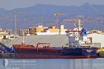
ZELIHA K
General Cargo
Current Trip
| Trip Time | 3 days |
|---|---|
| Trip Distance | 943.50 nm |
| AVG Speed | 7.5 Knots |
| MAX Speed | 7.5 Knots |
| Draught | 6.5 m |
| AVG Wind | 8.2 knots |
| MAX Wind | 20.9 knots |
| MIN Temp | 19.5°C / 67.1°F |
| MAX Temp | 34°C / 93.2°F |
| Position Received | 1 m ago |
Current Position
| Longitude | 41.65172° |
|---|---|
| Latitude | 41.64763° |
| Status | Moored |
| Speed | 0.1 Knots |
| Course | 259° |
| Area | Black Sea |
| Station | T-AIS |
| Position Received | 1 m ago |
Info
Information
The current position of ZELIHA K is in Black Sea with coordinates 41.64763° / 41.65172° as reported on 2024-06-06 20:50 by AIS to our vessel tracker app. The vessel's current speed is 0.1 Knots and is currently inside the port of BATUMI.
The vessel ZELIHA K (IMO: 9395185, MMSI: 353427000) is a General Cargo that was built in 2007 ( 17 years old ). It's sailing under the flag of [PA] Panama.
In this page you can find informations about the vessels current position, last detected port calls, and current voyage information. If the vessels is not in coverage by AIS you will find the latest position.
The current position of ZELIHA K is detected by our AIS receivers and we are not responsible for the reliability of the data. The last position was recorded while the vessel was in Coverage by the Ais receivers of our vessel tracking app.
The current draught of ZELIHA K as reported by AIS is 6.5 meters
Weather
| Temperature | 19.1°C / 66.38°F |
|---|---|
| Wind Speed | 5 knots |
| Direction | 174° S |
| Pressure | 1017.1 hPa |
| Humidity | 78.4 % |
| Cloud Coverage | --- |
Featured Company
Last Port Calls
| Port | Arrival | Departure | Time In Port |
|---|---|---|---|
| 2024-06-06 16:58 | |||
| 2024-06-03 13:03 | 2024-06-03 13:33 | 30 m | |
| 2024-06-01 02:43 | 2024-06-01 23:23 | 20 h | |
| 2024-05-25 05:28 | 2024-05-30 09:10 | 5 d | |
| 2024-05-16 20:53 | 2024-05-23 19:30 | 6 d | |
| 2024-05-02 21:23 | 2024-05-04 20:23 | 1 d | |
| 2024-05-01 01:25 | 2024-05-01 11:50 | 10 h | |
| 2024-04-25 13:36 | 2024-04-25 14:11 | 34 m | |
| 2024-04-25 04:59 | |||
| 2024-04-17 13:50 |
Last Trips
| Origin | Departure | Destination | Arrival | Distance | |
|---|---|---|---|---|---|
| 2024-06-03 16:33 | 2024-06-06 20:58 | 943.50 nm | |||
| 2024-06-02 02:23 | 2024-06-03 16:03 | 50.53 nm | |||
| 2024-05-30 12:10 | 2024-06-01 05:43 | 359.20 nm | |||
| 2024-05-23 22:30 | 2024-05-25 08:28 | 199.25 nm | |||
| 2024-05-04 23:23 | 2024-05-16 23:53 | 280.83 nm | |||
| 2024-05-01 14:50 | 2024-05-03 00:23 | 59.37 nm | |||
| 2024-04-25 17:11 | 2024-05-01 04:25 | 318.05 nm | |||
| 2024-04-25 07:59 | 2024-04-25 16:36 | 64.88 nm | |||
| 2024-04-06 10:22 | 2024-04-13 12:37 | 1021.61 nm | |||
| 2024-04-01 15:45 | 2024-04-03 12:19 | 106.04 nm |
Events
| Time | Event | Details | Position / Dest | Info |
|---|---|---|---|---|
| 2024-06-06 17:23 | Status Changed | Moored Under way using engine |
41.64771 / 41.65167
[GE] BATUMI
|
Speed: 0.1 kn Course: 259° |
| 2024-06-06 17:17 | STOP Moving |
41.64820 / 41.65131
[GE] BATUMI
|
Speed: 0.3 kn Course: 245° |
|
| 2024-06-06 16:58 | PORT ARRIVAL |
|
41.65803 / 41.64623
[GE] BATUMI
|
Speed: 4.3 kn Course: 172° |
| 2024-06-06 16:30 | START Moving | 1.9 nm, North East of BATUMI |
41.68109 / 41.66839
GEBUS
|
Speed: 4.2 kn Course: 253° |
| 2024-06-06 16:25 | Status Changed | Under way using engine At anchor |
41.68184 / 41.67204
GEBUS
|
Speed: Course: 229° |
| 2024-06-06 11:15 | STOP Moving | 1.97 nm, North East of BATUMI |
41.68120 / 41.67149
GEBUS
|
Speed: 0.3 kn Course: 48° |
| 2024-06-06 11:08 | Status Changed | At anchor Under way using engine |
41.68153 / 41.67087
GEBUS
|
Speed: 0.6 kn Course: 84° |
| 2024-06-06 10:15 | Change Sea Area | Georgian part of the Black Sea Turkish part of the Black Sea |
41.68377 / 41.58040
Black Sea
|
Speed: 8.7 kn Course: 58.8° |
| 2024-06-06 10:15 | IN Coverage |
41.68377 / 41.58040
Black Sea
|
Speed: 8.7 kn Course: 58.8° |
|
| 2024-06-05 14:06 | OUT of Coverage |
45.28446 / 34.69390
Black Sea
GEBUS
|
Speed: 78 kn Course: 214.3° |