
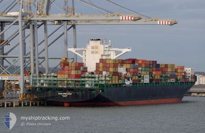
ZIM WILMINGTON
Cargo A
Current Trip
| Time Travelled | 16 days |
|---|---|
| Remaining Time | --- |
| Distance Travelled | 7069.21 nm |
| Remaining Distance | --- |
| AVG Speed | 18.5 Knots |
| MAX Speed | 23.8 Knots |
| AVG Wind | 10.3 knots |
| MAX Wind | 20.9 knots |
| MIN Temp | 7.2°C / 44.96°F |
| MAX Temp | 32.1°C / 89.78°F |
| Draught | 10.8 m |
| Position Received | 5 d ago |
Current Position
| Longitude | -125.64757° |
|---|---|
| Latitude | 32.62474° |
| Status | Under way using engine |
| Speed | 19.2 Knots |
| Course | 308.7° |
| Area | North Pacific Ocean |
| Station | T-AIS |
| Position Received | 5 d ago |
Info
Information
The current position of ZIM WILMINGTON is in North Pacific Ocean with coordinates 32.62474° / -125.64757° as reported on 2024-06-14 23:41 by AIS to our vessel tracker app. The vessel's current speed is 19.2 Knots and is heading at the port of XIAMEN. The estimated time of arrival as calculated by vessel tracking app is 2024-06-28 03:00 LT
The vessel ZIM WILMINGTON (IMO: 9699115, MMSI: 538007097) is a Cargo A It's sailing under the flag of [MH] Marshall Is.
In this page you can find informations about the vessels current position, last detected port calls, and current voyage information. If the vessels is not in coverage by AIS you will find the latest position.
The current position of ZIM WILMINGTON is detected by our AIS receivers and we are not responsible for the reliability of the data. The last position was recorded while the vessel was in Coverage by the Ais receivers of our vessel tracking app.
The current draught of ZIM WILMINGTON as reported by AIS is 10.8 meters
Weather
| Temperature | 7.2°C / 44.96°F |
|---|---|
| Wind Speed | 4 knots |
| Direction | 52° NE |
| Pressure | 1014.9 hPa |
| Humidity | 94.1 % |
| Cloud Coverage | 71 % |
Featured Company
Last Port Calls
| Port | Arrival | Departure | Time In Port |
|---|---|---|---|
| 2024-06-02 16:56 | 2024-06-04 09:43 | 1 d | |
| 2024-05-28 15:35 | 2024-05-29 12:00 | 20 h | |
| 2024-05-23 17:53 | 2024-05-26 20:57 | 3 d | |
| 2024-04-24 07:17 | 2024-04-30 10:33 | 6 d |
Last Trips
| Origin | Departure | Destination | Arrival | Distance | |
|---|---|---|---|---|---|
| 2024-05-29 07:00 | 2024-06-02 12:56 | 550.48 nm | |||
| 2024-05-26 15:57 | 2024-05-28 10:35 | 583.93 nm | |||
| 2024-04-30 19:33 | 2024-05-23 12:53 | 9958.51 nm | |||
| 2024-03-24 16:18 | 2024-04-24 16:17 | 9628.84 nm |
Events
| Time | Event | Details | Position / Dest | Info |
|---|---|---|---|---|
| 2024-06-14 23:47 | Status Changed | Default Under way using engine |
32.64674 / -125.67947
CNXMN
|
Speed: 19.2 kn Course: 308.7° |
| 2024-06-14 23:41 | Status Changed | Under way using engine Default |
32.62474 / -125.64757
CNXMN
|
Speed: 19.1 kn Course: 308° |
| 2024-06-14 23:41 | OUT of Coverage |
32.62474 / -125.64757
North Pacific Ocean
CNXMN
|
Speed: 19.2 kn Course: 308.7° |
|
| 2024-06-14 23:26 | IN Coverage |
32.62474 / -125.64757
North Pacific Ocean
CNXMN
|
Speed: 19.2 kn Course: 308.7° |
|
| 2024-06-14 17:39 | Status Changed | Default Under way using engine |
31.47833 / -123.88666
CNXMN
|
Speed: 18.3 kn Course: 307.4° |
| 2024-06-14 17:34 | OUT of Coverage |
31.46497 / -123.86544
North Pacific Ocean
CNXMN
|
Speed: 18.3 kn Course: 307.4° |
|
| 2024-06-14 17:28 | Status Changed | Under way using engine Default |
31.44579 / -123.83624
CNXMN
|
Speed: 18 kn Course: 308° |
| 2024-06-14 17:10 | IN Coverage |
31.44917 / -123.84134
North Pacific Ocean
CNXMN
|
Speed: 18.4 kn Course: 307.5° |
|
| 2024-06-14 14:46 | Status Changed | Default Under way using engine |
30.93136 / -123.09385
CNXMN
|
Speed: 18.2 kn Course: 309.2° |
| 2024-06-14 14:41 | OUT of Coverage |
30.91749 / -123.07410
North Pacific Ocean
CNXMN
|
Speed: 18.2 kn Course: 309.2° |