
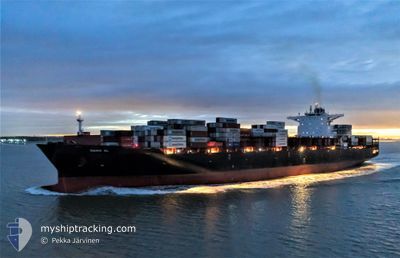
ZIM XIAMEN
Cargo A
Current Trip
| Time Travelled | 21 days |
|---|---|
| Remaining Time | --- |
| Distance Travelled | 7602.39 nm |
| Remaining Distance | --- |
| AVG Speed | 15.2 Knots |
| MAX Speed | 18.1 Knots |
| AVG Wind | 12.1 knots |
| MAX Wind | 32.9 knots |
| MIN Temp | 9.5°C / 49.1°F |
| MAX Temp | 30.3°C / 86.54°F |
| Draught | 10.3 m |
| Position Received | Now |
Current Position
| Longitude | 140.59839° |
|---|---|
| Latitude | 41.52492° |
| Status | Under way using engine |
| Speed | 16.6 Knots |
| Course | 232.5° |
| Area | Japan Sea |
| Station | T-AIS |
| Position Received | Now |
Info
Information
The current position of ZIM XIAMEN is in Japan Sea with coordinates 41.52492° / 140.59839° as reported on 2024-06-08 22:29 by AIS to our vessel tracker app. The vessel's current speed is 16.6 Knots and is heading at the port of XIAMEN. The estimated time of arrival as calculated by vessel tracking app is 2024-06-13 03:00 LT
The vessel ZIM XIAMEN (IMO: 9710232, MMSI: 636016985) is a Cargo A It's sailing under the flag of [LR] Liberia.
In this page you can find informations about the vessels current position, last detected port calls, and current voyage information. If the vessels is not in coverage by AIS you will find the latest position.
The current position of ZIM XIAMEN is detected by our AIS receivers and we are not responsible for the reliability of the data. The last position was recorded while the vessel was in Coverage by the Ais receivers of our vessel tracking app.
The current draught of ZIM XIAMEN as reported by AIS is 10.3 meters
Weather
| Temperature | 14.7°C / 58.46°F |
|---|---|
| Wind Speed | 3 knots |
| Direction | 84° E |
| Pressure | 1014.1 hPa |
| Humidity | 89.4 % |
| Cloud Coverage | 100 % |
Featured Company
Last Port Calls
| Port | Arrival | Departure | Time In Port |
|---|---|---|---|
| 2024-05-18 01:18 | 2024-05-18 20:02 | 18 h | |
| 2024-05-15 07:06 | 2024-05-16 00:10 | 17 h | |
| 2024-05-09 15:26 | 2024-05-11 00:13 | 1 d | |
| 2024-05-06 19:10 | 2024-05-07 19:54 | 1 d | |
| 2024-04-30 17:32 | 2024-05-03 14:15 | 2 d | |
| 2024-04-04 21:59 | 2024-04-06 06:00 | 1 d |
Last Trips
| Origin | Departure | Destination | Arrival | Distance | |
|---|---|---|---|---|---|
| 2024-05-15 19:10 | 2024-05-17 20:18 | 58.17 nm | |||
| 2024-05-10 20:13 | 2024-05-15 02:06 | 1234.09 nm | |||
| 2024-05-07 14:54 | 2024-05-09 11:26 | 416.74 nm | |||
| 2024-05-03 09:15 | 2024-05-06 14:10 | 578.45 nm | |||
| 2024-04-06 15:00 | 2024-04-30 12:32 | 9774.40 nm | |||
| 2024-04-01 04:00 | 2024-04-05 06:59 | 1175.35 nm |
Events
| Time | Event | Details | Position / Dest | Info |
|---|---|---|---|---|
| 2024-06-08 20:37 | Change Sea Area | Japanese part of the Japan Sea Japanese part of the North Pacific Ocean |
41.65323 / 141.25909
Japan Sea
CNXMN
|
Speed: 17.2 kn Course: 263° |
| 2024-06-08 18:07 | Status Changed | Under way using engine Default |
41.72093 / 142.18151
CNXMN
|
Speed: 17.2 kn Course: 264° |
| 2024-06-08 18:01 | Status Changed | Default Under way using engine |
41.72386 / 142.21628
CNXMN
|
Speed: 17.1 kn Course: 265° |
| 2024-06-08 17:55 | Status Changed | Under way using engine Default |
41.72727 / 142.25878
CNXMN
|
Speed: 17.1 kn Course: 265° |
| 2024-06-08 17:53 | Status Changed | Default Under way using engine |
41.72783 / 142.26703
CNXMN
|
Speed: 17 kn Course: 263.8° |
| 2024-06-08 17:46 | Change Sea Area | Japanese part of the North Pacific Ocean Mexican part of the North Pacific Ocean |
41.73116 / 142.31169
North Pacific Ocean
CNXMN
|
Speed: 16.9 kn Course: 264.2° |
| 2024-06-08 17:46 | Status Changed | Under way using engine Default |
41.73116 / 142.31169
CNXMN
|
Speed: 16.9 kn Course: 265° |
| 2024-06-08 17:37 | IN Coverage |
41.73116 / 142.31169
North Pacific Ocean
CNXMN
|
Speed: 16.9 kn Course: 264.2° |